
Bestand:Şanlıurfa districts.png
Grootte van deze voorvertoning: 788 × 600 pixels. Andere resoluties: 315 × 240 pixels | 631 × 480 pixels | 1.010 × 769 pixels.
Oorspronkelijk bestand (1.010 × 769 pixels, bestandsgrootte: 27 kB, MIME-type: image/png)
| Dit is een bestand van Wikimedia Commons. Onderstaande beschrijving komt van de beschrijving van het bestand daar. |

|
Deze kaartafbeelding zou opnieuw moeten worden aangemaakt als een SVG-bestand door vectorafbeeldingen te gebruiken. Dit heeft een aantal voordelen; zie Commons:Media for cleanup voor meer informatie. Als er een SVG-formaat van deze afbeelding bestaat, dan deze graag uploaden. Nadat u dit heeft gedaan, gelieve dit sjabloon te vervangen door het sjabloon {{vector version available|nieuwe bestandsnaam.svg}} op deze afbeeldingspagina.
|
Beschrijving
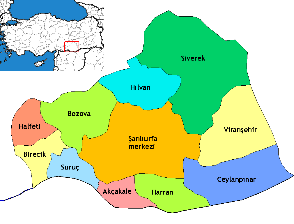
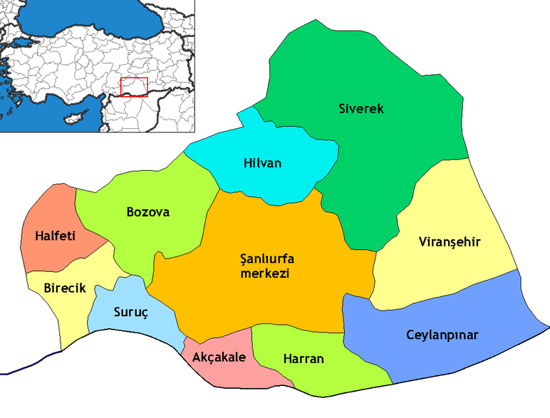
Map of the districts of Şanlıurfa province in Turkey. Created by Rarelibra 17:13, 4 December 2006 (UTC) for public domain use, using MapInfo Professional v8.5 and various mapping resources. Edited by One Homo Sapiens Corrected text where İ,Ş,ı,ğ,or ş occurs in name. Source: [statoids-com]. Increased font size and enhanced color differences among adjacent districts.
Licentie
Ik, de auteursrechthebbende van dit werk, maak het hierbij onder de volgende licentie beschikbaar:
Dit bestand is gelicenseerd onder de Creative Commons-licentie Naamsvermelding-Gelijk delen 2.5 Unported
- De gebruiker mag:
- Delen – het werk kopiëren, verspreiden en doorgeven
- Remixen – afgeleide werken maken
- Onder de volgende voorwaarden:
- naamsvermelding – U moet op een gepaste manier aan naamsvermelding doen, een link naar de licentie geven, en aangeven of er wijzigingen in het werk zijn aangebracht. U mag dit op elke redelijke manier doen, maar niet zodanig dat de indruk wordt gewekt dat de licentiegever instemt met uw werk of uw gebruik van zijn werk.
- Gelijk delen – Als u het werk heeft geremixt, veranderd, of erop heeft voortgebouwd, moet u het gewijzigde materiaal verspreiden onder dezelfde licentie als het oorspronkelijke werk, of een daarmee compatibele licentie.
Bestandsgeschiedenis
Klik op een datum/tijd om het bestand te zien zoals het destijds was.
| Datum/tijd | Miniatuur | Afmetingen | Gebruiker | Opmerking | |
|---|---|---|---|---|---|
| huidige versie | 6 nov 2009 03:19 | | 1.010 × 769 (27 kB) | ZooFari | Trimmed |
| 29 dec 2008 04:29 |  | 1.056 × 816 (28 kB) | One Homo Sapiens | Corrected text where İ,Ş,ı,ğ,or ş occurs in name. Source: [statoids-com]. Increased font size and enhanced color differences among adjacent districts. | |
| 16 apr 2007 00:03 |  | 1.056 × 816 (33 kB) | Denizz~commonswiki | == Summary == Map of the districts of Şanlıurfa province in Turkey. Created by Rarelibra 17:13, 4 December 2006 (UTC) for public domain use, using MapInfo Professional v8.5 and various mapping resources. == Licensing == {{self|cc-by-s |
Bestandsgebruik
Dit bestand wordt op de volgende 14 pagina's gebruikt:
Globaal bestandsgebruik
De volgende andere wiki's gebruiken dit bestand:
- Gebruikt op ar.wikipedia.org
- Gebruikt op ast.wikipedia.org
- Gebruikt op avk.wikipedia.org
- Gebruikt op ca.wikipedia.org
- Gebruikt op diq.wikipedia.org
- Qori
- Babıci
- Şablon:Karber Sêwrege
- Şablon:Karber Rıha
- Alan, Sêwrege
- Alanqoz
- Anazo
- Arastul
- Axsun
- Bab
- Babvêren
- Bahser
- Sahrık
- İniyoderg
- Tıl
- Xırabrês
- Hop, Sêwrege
- Modan, Sêwrege
- Mextele
- Qetine
- Hadro
- Kelosk
- Kolik
- Baxce
- Benek
- Bexdes
- Bideri
- Boxcık
- Bitik
- Buxdikan
- Catax
- Celkani
- Celtug
- Dewık (Sêwrege)
- Alangoza Cêri
- Cepni
- Cımo qelısi
- Daragon
- Dinar (dewe)
- Gerisar
- Bılerız
- Qışlan
- Herheri
- Xalokend
- Salıcan
- Xarzeno
Globaal gebruik van dit bestand bekijken.