
Bestand:16May-21May1940-Fall Gelb.svg

Afmetingen van deze voorvertoning van het type PNG van dit SVG-bestand: 773 × 600 pixels Andere resoluties: 309 × 240 pixels | 619 × 480 pixels | 990 × 768 pixels | 1.280 × 993 pixels | 2.560 × 1.987 pixels | 889 × 690 pixels.
Oorspronkelijk bestand (SVG-bestand, nominaal 889 × 690 pixels, bestandsgrootte: 2,06 MB)
| Dit is een bestand van Wikimedia Commons. Onderstaande beschrijving komt van de beschrijving van het bestand daar. |
Beschrijving
| Beschrijving |
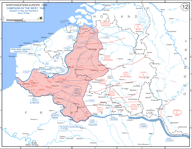
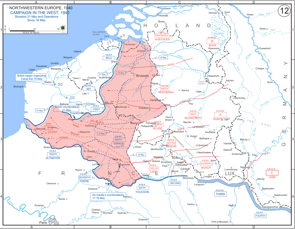
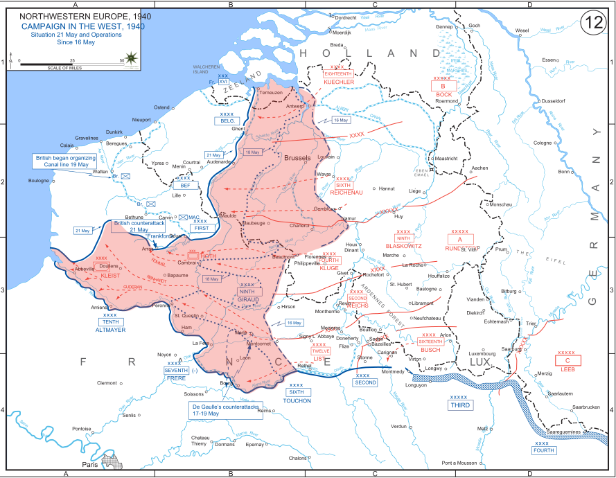
English: The German advance between 16 May and 21 May 1940. The red area denotes the territory captured by Germany during this time. The German field armies and Corps are shown in red. The operating area of the various Belgian, British, and French field armies and Army groups are shown in blue. The checkered white and blue area denotes the French Maginot Line. The commanders of the various units are shown under their respective formation. Solid lines represent the boundaries between each major unit. Dotted lines depict lines of advance. Key dates are shown in boxes. |
| Datum | |
| Bron | Archive link to original website used for the map and the archive link to the map source page. Current link to map, and link to map source page. |
| Auteur | The History Department of the United States Military Academy |
| Andere versies |
|


Licentie
Deze afbeelding is een werk van een soldaat of werknemer van de U.S. Army, genomen of gemaakt tijdens de uitvoering van diens officiële taken. Als werk van de federale overheid van de Verenigde Staten bevindt deze afbeelding zich in het publiek domein.
|
 |
Bestandsgeschiedenis
Klik op een datum/tijd om het bestand te zien zoals het destijds was.
| Datum/tijd | Miniatuur | Afmetingen | Gebruiker | Opmerking | |
|---|---|---|---|---|---|
| huidige versie | 29 dec 2011 21:07 | | 889 × 690 (2,06 MB) | Zscout370 | The text was displaying oddly in this SVG. |
| 29 dec 2011 21:07 |  | 889 × 690 (463 kB) | Addihockey10 | test | |
| 24 sep 2010 04:58 |  | 889 × 690 (334 kB) | Tazadeperla | {{Information |Description={{en|1=Vector version of file 1940FranceBlitz.jpg}} |Source=http://www.dean.usma.edu/history/web03/atlases/ww2%20europe/WWIIEuropeIndex.html |Author=The History Dept at the United States Army Academy |Date= |Permission= |other_v |
Bestandsgebruik
Dit bestand wordt op de volgende pagina gebruikt:
Globaal bestandsgebruik
De volgende andere wiki's gebruiken dit bestand:
- Gebruikt op af.wikipedia.org
- Gebruikt op ar.wikipedia.org
- Gebruikt op azb.wikipedia.org
- Gebruikt op bn.wikipedia.org
- Gebruikt op br.wikipedia.org
- Gebruikt op bs.wikipedia.org
- Gebruikt op ca.wikipedia.org
- Gebruikt op cs.wikipedia.org
- Gebruikt op da.wikipedia.org
- Gebruikt op en.wikipedia.org
- Gebruikt op fi.wikipedia.org
- Gebruikt op fr.wikipedia.org
- Gebruikt op gl.wikipedia.org
- Gebruikt op he.wikipedia.org
- Gebruikt op id.wikipedia.org
- Gebruikt op it.wikipedia.org
- Gebruikt op ja.wikipedia.org
- Gebruikt op ko.wikipedia.org
- Gebruikt op lt.wikipedia.org
- Gebruikt op lv.wikipedia.org
- Gebruikt op no.wikipedia.org
- Gebruikt op pl.wikipedia.org
- Gebruikt op pt.wikipedia.org
- Gebruikt op ro.wikipedia.org
- Gebruikt op ru.wikipedia.org
- Gebruikt op simple.wikipedia.org
- Gebruikt op sl.wikipedia.org
- Gebruikt op sr.wikipedia.org
- Gebruikt op th.wikipedia.org
Globaal gebruik van dit bestand bekijken.