
Bestand:Autonomous Region Kurdistan-en.png
Grootte van deze voorvertoning: 581 × 599 pixels. Andere resoluties: 233 × 240 pixels | 465 × 480 pixels | 1.012 × 1.044 pixels.
Oorspronkelijk bestand (1.012 × 1.044 pixels, bestandsgrootte: 514 kB, MIME-type: image/png)
| Dit is een bestand van Wikimedia Commons. Onderstaande beschrijving komt van de beschrijving van het bestand daar. |
Beschrijving
| Beschrijving |
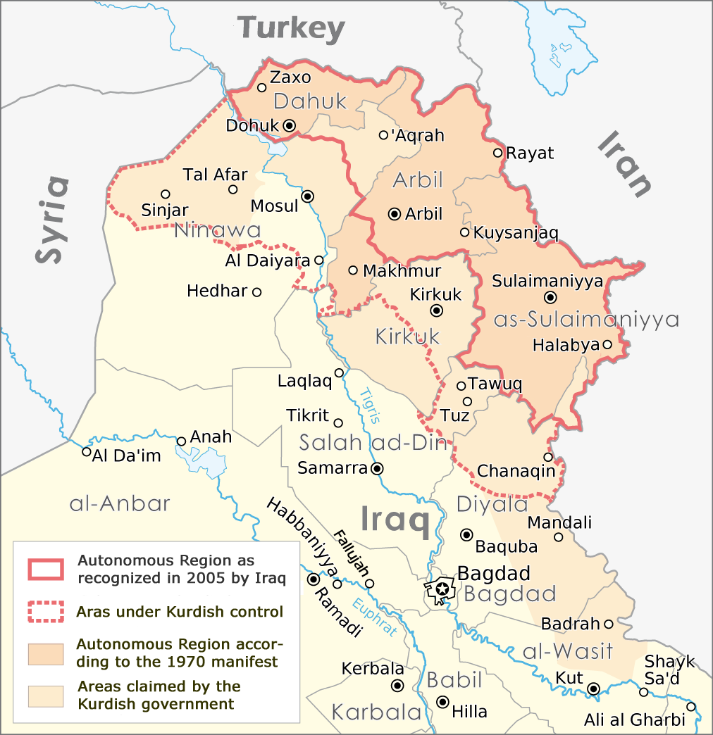
English: Map of the Autonomous Region Kurdistan, created by Maximilian Dörrbecker,
translated into English by ilyacadiz |
| Datum | |
| Bron | Autonome Region Kurdistan (Karte).png |
| Auteur |
Maximilian Dörrbecker (Chumwa), derviative work by ilyacadiz |
| Andere versies |
|
.png)
Licentie
Dit bestand is gelicenseerd onder de Creative Commons-licentie Naamsvermelding-Gelijk delen 3.0 Unported
- De gebruiker mag:
- Delen – het werk kopiëren, verspreiden en doorgeven
- Remixen – afgeleide werken maken
- Onder de volgende voorwaarden:
- naamsvermelding – U moet op een gepaste manier aan naamsvermelding doen, een link naar de licentie geven, en aangeven of er wijzigingen in het werk zijn aangebracht. U mag dit op elke redelijke manier doen, maar niet zodanig dat de indruk wordt gewekt dat de licentiegever instemt met uw werk of uw gebruik van zijn werk.
- Gelijk delen – Als u het werk heeft geremixt, veranderd, of erop heeft voortgebouwd, moet u het gewijzigde materiaal verspreiden onder dezelfde licentie als het oorspronkelijke werk, of een daarmee compatibele licentie.
Bestandsgeschiedenis
Klik op een datum/tijd om het bestand te zien zoals het destijds was.
| Datum/tijd | Miniatuur | Afmetingen | Gebruiker | Opmerking | |
|---|---|---|---|---|---|
| huidige versie | 20 okt 2017 13:02 | | 1.012 × 1.044 (514 kB) | Rob984 | The southern part of the Kifri district was not incorporated. The northern part in the Sulaymaniyah Governorate was, which may be the reason for the confusions (there is effectively two "Kifri districts") |
| 14 okt 2008 19:37 |  | 1.012 × 1.044 (535 kB) | Ilyacadiz | {{Information |Description={{en|1=Map of the Autonomous Region Kurdistan, created by Maximilian Dörrbecker, translated into English by ilyacadiz }} |Source=Image:Autonome Region Kurdistan (Karte).png |Author=Maximilian Dörrbecker (Chumwa) |Date=October |
Bestandsgebruik
Dit bestand wordt op de volgende pagina gebruikt:
Globaal bestandsgebruik
De volgende andere wiki's gebruiken dit bestand:
- Gebruikt op af.wikipedia.org
- Gebruikt op ca.wikipedia.org
- Gebruikt op ckb.wikipedia.org
- Gebruikt op en.wikipedia.org
- Gebruikt op fa.wikipedia.org
- Gebruikt op fr.wikipedia.org
- Gebruikt op he.wikipedia.org
- Gebruikt op hr.wikipedia.org
- Gebruikt op it.wikipedia.org
- Gebruikt op ku.wikipedia.org
- Gebruikt op no.wikipedia.org
- Gebruikt op sh.wikipedia.org
- Gebruikt op sr.wikipedia.org