
Bestand:BART-WS-extension-map.png
Geen hogere resolutie beschikbaar.
BART-WS-extension-map.png (521 × 537 pixels, bestandsgrootte: 85 kB, MIME-type: image/png)
| Dit is een bestand van Wikimedia Commons. Onderstaande beschrijving komt van de beschrijving van het bestand daar. |
Beschrijving

|
Bestand:BART WSX overlay.svg is een vectorversie van dit bestand. Indien niet van slechtere kwaliteit dient deze gebruikt te worden in plaats van deze rasterafbeelding.
File:BART-WS-extension-map.png → File:BART WSX overlay.svg
Zie Help:SVG voor meer informatie. |
 |
| Beschrijving |
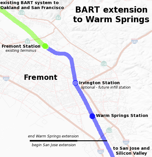
English: Map of the planned Bay Area Rapid Transit extension to Warm Springs. The background map of Fremont was generated by the USGS National Map. The route and plans are based on data from BART including the Warm Springs project alignment description. |
| Datum | |
| Bron | Eigen werk |
| Auteur | Ikluft |
Licentie
Ik, de auteursrechthebbende van dit werk, maak het hierbij onder de volgende licentie beschikbaar:
Dit bestand is gelicenseerd onder de Creative Commons-licentie Naamsvermelding-Gelijk delen 3.0 Unported
- De gebruiker mag:
- Delen – het werk kopiëren, verspreiden en doorgeven
- Remixen – afgeleide werken maken
- Onder de volgende voorwaarden:
- naamsvermelding – U moet op een gepaste manier aan naamsvermelding doen, een link naar de licentie geven, en aangeven of er wijzigingen in het werk zijn aangebracht. U mag dit op elke redelijke manier doen, maar niet zodanig dat de indruk wordt gewekt dat de licentiegever instemt met uw werk of uw gebruik van zijn werk.
- Gelijk delen – Als u het werk heeft geremixt, veranderd, of erop heeft voortgebouwd, moet u het gewijzigde materiaal verspreiden onder dezelfde licentie als het oorspronkelijke werk, of een daarmee compatibele licentie.
Bestandsgeschiedenis
Klik op een datum/tijd om het bestand te zien zoals het destijds was.
| Datum/tijd | Miniatuur | Afmetingen | Gebruiker | Opmerking | |
|---|---|---|---|---|---|
| huidige versie | 2 jan 2017 23:42 | | 521 × 537 (85 kB) | Jeanjung212 | Lossless Compressed/optimized png decreasing file size by 48050 bytes |
| 14 dec 2008 02:52 |  | 521 × 537 (132 kB) | Ikluft | major cleanup - add mid-background layer with highways and highway shields | |
| 7 dec 2008 13:19 |  | 521 × 537 (180 kB) | Ikluft | {{Information |Description={{en|1=Map of the planned Bay Area Rapid Transit extension to Warm Springs. The background map of Fremont was generated by the [http://www.nationalmap.gov/ USGS National Map]. The route and plans are |
Bestandsgebruik
Dit bestand wordt op de volgende pagina gebruikt:
Globaal bestandsgebruik
De volgende andere wiki's gebruiken dit bestand:
- Gebruikt op en.wikipedia.org