
Bestand:Carquinez Strait aerial view.jpg

Grootte van deze voorvertoning: 800 × 533 pixels. Andere resoluties: 320 × 213 pixels | 640 × 426 pixels | 1.024 × 682 pixels | 1.500 × 999 pixels.
Oorspronkelijk bestand (1.500 × 999 pixels, bestandsgrootte: 840 kB, MIME-type: image/jpeg)
| Dit is een bestand van Wikimedia Commons. Onderstaande beschrijving komt van de beschrijving van het bestand daar. |
| Beschrijving |
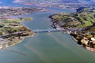
English: Aerial view of Carquinez Strait, which is the outflow of the Sacramento River into San Pablo Bay between Solano and Contra Costa Counties, California, USA. In the photograph, Solano County is on the left of the strait and Contra Costa County is on the right. The Carquinez Bridge, carrying Interstate 80, is visible in the foreground. The Benicia-Martinez Bridge is visible in the far distance. The communities of Crocket, Port Costa, and Martinez lie on the right side in Contra Costa County. The city of Vallejo lies off to the left, not visible in the picture. Benicia, California, is visible at top left. Through Carquinez Strait and Suisun Bay, the river is navigable by deep-water vessels.
Coordinates: 38°3′43.25″N 122°13′34.18″W / 38.0620139°N 122.2261611°W |
||
| Datum | not specified or unknown | ||
| Bron |
U.S. Army Corps of Engineers Digital Visual Library Image page Image description page Digital Visual Library home page |
||
| Auteur | Robert Campbell | ||
| Toestemming (Hergebruik van dit bestand) |
Dit bestand is gelicenseerd onder de Creative Commons-licentie Naamsvermelding-Gelijk delen 3.0 Unported
|
||
| Locatie | Solano and Contra Costa Counties, California, USA |

Bestandsgeschiedenis
Klik op een datum/tijd om het bestand te zien zoals het destijds was.
| Datum/tijd | Miniatuur | Afmetingen | Gebruiker | Opmerking | |
|---|---|---|---|---|---|
| huidige versie | 4 mei 2007 03:02 | | 1.500 × 999 (840 kB) | DanMS | {{Information | Description = {{en|Aerial view of Carquinez Strait, which is the outflow of the Sacramento River into San Pablo Bay between Solano and Contra Costa Counties, California, USA. In the photograph, Solano County is on the left of the strait |
Bestandsgebruik
Dit bestand wordt op de volgende 2 pagina's gebruikt:
Globaal bestandsgebruik
De volgende andere wiki's gebruiken dit bestand:
- Gebruikt op ar.wikipedia.org
- Gebruikt op ca.wikipedia.org
- Gebruikt op ceb.wikipedia.org
- Gebruikt op de.wikipedia.org
- Gebruikt op en.wikipedia.org
- Gebruikt op fa.wikipedia.org
- Gebruikt op fr.wikipedia.org
- Gebruikt op gl.wikipedia.org
- Gebruikt op it.wikipedia.org
- Gebruikt op ja.wikipedia.org
- Gebruikt op ko.wikipedia.org
- Gebruikt op pt.wikipedia.org
- Gebruikt op www.wikidata.org