
Bestand:Caucasus 1311 AD map de.png

Grootte van deze voorvertoning: 771 × 600 pixels. Andere resoluties: 309 × 240 pixels | 617 × 480 pixels | 988 × 768 pixels | 1.280 × 995 pixels | 2.560 × 1.991 pixels | 2.995 × 2.329 pixels.
Oorspronkelijk bestand (2.995 × 2.329 pixels, bestandsgrootte: 3,38 MB, MIME-type: image/png)
| Dit is een bestand van Wikimedia Commons. Onderstaande beschrijving komt van de beschrijving van het bestand daar. |
Beschrijving
| Beschrijving |
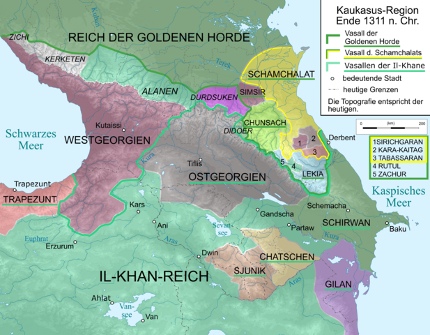
English: Map of Caucasus Region around 1380 in German.
Deutsch: Kaukasus-Region um 1311 n. Chr. Quellen sind: * Michael Kemper: Herrschaft, Recht und Islam in Daghestan. Von den Khanaten und Gemeindebünden zum ǧihād-Staat. Wiesbaden 2005. S. 30–111.
|
| Datum | |
| Bron | Eigen werk, derivative of File:Caucasus_topographic_map-fr.svg |
| Auteur |
|
| Andere versies |
 |
Licentie
Ik, de auteursrechthebbende van dit werk, maak het hierbij onder de volgende licenties beschikbaar:

|
Toestemming wordt verleend voor het kopiëren, verspreiden en/of wijzigen van dit document onder de voorwaarden van de GNU-licentie voor vrije documentatie, versie 1.2 of enige latere versie als gepubliceerd door de Free Software Foundation; zonder Invariant Sections, zonder Front-Cover Texts, en zonder Back-Cover Texts. Een kopie van de licentie is opgenomen in de sectie GNU-licentie voor vrije documentatie. |
Dit bestand is gelicenseerd onder de Creative Commons-licenties Naamsvermelding-Gelijk delen 3.0 Unported, 2.5 Algemeen, 2.0 Algemeen en 1.0 Algemeen.
- De gebruiker mag:
- Delen – het werk kopiëren, verspreiden en doorgeven
- Remixen – afgeleide werken maken
- Onder de volgende voorwaarden:
- naamsvermelding – U moet op een gepaste manier aan naamsvermelding doen, een link naar de licentie geven, en aangeven of er wijzigingen in het werk zijn aangebracht. U mag dit op elke redelijke manier doen, maar niet zodanig dat de indruk wordt gewekt dat de licentiegever instemt met uw werk of uw gebruik van zijn werk.
- Gelijk delen – Als u het werk heeft geremixt, veranderd, of erop heeft voortgebouwd, moet u het gewijzigde materiaal verspreiden onder dezelfde licentie als het oorspronkelijke werk, of een daarmee compatibele licentie.
U mag zelf één van de licenties kiezen.
Bestandsgeschiedenis
Klik op een datum/tijd om het bestand te zien zoals het destijds was.
| Datum/tijd | Miniatuur | Afmetingen | Gebruiker | Opmerking | |
|---|---|---|---|---|---|
| huidige versie | 9 apr 2020 19:25 | | 2.995 × 2.329 (3,38 MB) | Don-kun | small fix for Rutul+Zachur |
| 8 apr 2020 19:30 |  | 3.000 × 2.332 (3,39 MB) | Don-kun | Changes according to ongoing discussion and new sources (will be added soon) | |
| 13 okt 2010 21:42 |  | 3.000 × 2.332 (3,6 MB) | Don-kun | {{Information |Description={{en|1=Map of Caucasus Region around 1311 AD in German.}} {{de|1=Kaukasus-Region um 1311 n. Chr. Quellen sind: * Heinz Fähnrich: ''Geschichte Georgiens von den Anfängen bis zur Mongolenherrschaft''. Shaker, Aachen 1993, ISBN 3 |
Bestandsgebruik
Geen enkele pagina gebruikt dit bestand.
Globaal bestandsgebruik
De volgende andere wiki's gebruiken dit bestand:
- Gebruikt op als.wikipedia.org
- Gebruikt op de.wikipedia.org
- Gebruikt op en.wikipedia.org
- Gebruikt op fr.wikipedia.org
- Gebruikt op lv.wikipedia.org
- Gebruikt op ru.wikipedia.org
- Gebruikt op tr.wikipedia.org
- Gebruikt op uk.wikipedia.org