
Bestand:Cyprus BufferZoneInBlue.png
Geen hogere resolutie beschikbaar.
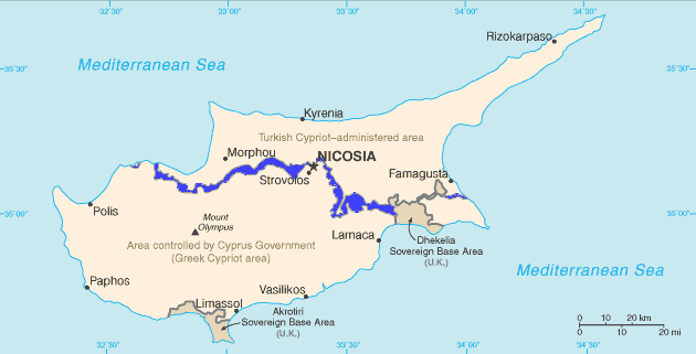
Cyprus_BufferZoneInBlue.png (630 × 321 pixels, bestandsgrootte: 21 kB, MIME-type: image/png)
| Dit is een bestand van Wikimedia Commons. Onderstaande beschrijving komt van de beschrijving van het bestand daar. |
English: Map of Cyprus with the UN Buffer Zone in blue. The map is adapted from the CIA World Factbook map.
Deze afbeelding bevindt zich in het publiek domein omdat het materiaal bevat dat oorspronkelijk afkomstig is van het CIA World Factbook.
|
 |
Bestandsgeschiedenis
Klik op een datum/tijd om het bestand te zien zoals het destijds was.
| Datum/tijd | Miniatuur | Afmetingen | Gebruiker | Opmerking | |
|---|---|---|---|---|---|
| huidige versie | 11 feb 2007 13:13 | | 630 × 321 (21 kB) | Hoshie | {{english}} Map of Cyprus with the UN Buffer Zone in blue, the traditional color on maps for British possessions. The map is adapted from the [http://www.cia.gov/cia/publications/factbook/maps/cy-map.gif CIA World Factbook] map. |
Bestandsgebruik
Dit bestand wordt op de volgende 10 pagina's gebruikt:
- Resolutie 1000 Veiligheidsraad Verenigde Naties
- Resolutie 1283 Veiligheidsraad Verenigde Naties
- Resolutie 1384 Veiligheidsraad Verenigde Naties
- Resolutie 1687 Veiligheidsraad Verenigde Naties
- Resolutie 1847 Veiligheidsraad Verenigde Naties
- Resolutie 1986 Veiligheidsraad Verenigde Naties
- Resolutie 472 Veiligheidsraad Verenigde Naties
- Resolutie 559 Veiligheidsraad Verenigde Naties
- Resolutie 927 Veiligheidsraad Verenigde Naties
- UNFICYP
Globaal bestandsgebruik
De volgende andere wiki's gebruiken dit bestand:
- Gebruikt op ar.wikipedia.org
- Gebruikt op ca.wikipedia.org
- Resolució 472 del Consell de Seguretat de les Nacions Unides
- Resolució 482 del Consell de Seguretat de les Nacions Unides
- Resolució 486 del Consell de Seguretat de les Nacions Unides
- Resolució 510 del Consell de Seguretat de les Nacions Unides
- Resolució 526 del Consell de Seguretat de les Nacions Unides
- Resolució 544 del Consell de Seguretat de les Nacions Unides
- Resolució 553 del Consell de Seguretat de les Nacions Unides
- Resolució 634 del Consell de Seguretat de les Nacions Unides
- Resolució 680 del Consell de Seguretat de les Nacions Unides
- Resolució 697 del Consell de Seguretat de les Nacions Unides
- Resolució 1000 del Consell de Seguretat de les Nacions Unides
- Resolució 1283 del Consell de Seguretat de les Nacions Unides
- Resolució 1384 del Consell de Seguretat de les Nacions Unides
- Resolució 1687 del Consell de Seguretat de les Nacions Unides
- Resolució 1847 del Consell de Seguretat de les Nacions Unides
- Resolució 1953 del Consell de Seguretat de les Nacions Unides
- Resolució 1986 del Consell de Seguretat de les Nacions Unides
- Zona coixí
- Gebruikt op ckb.wikipedia.org
- بڕیارنامەی ٤٧٢ی ئەنجومەنی ئاسایش
- بڕیارنامەی ٤٨٢ی ئەنجومەنی ئاسایش
- بڕیارنامەی ٤٨٦ی ئەنجومەنی ئاسایش
- بڕیارنامەی ٤٩٥ی ئەنجومەنی ئاسایش
- بڕیارنامەی ٥١٠ی ئەنجومەنی ئاسایش
- بڕیارنامەی ٥٢٦ی ئەنجومەنی ئاسایش
- بڕیارنامەی ٥٤٤ی ئەنجومەنی ئاسایش
- بڕیارنامەی ٥٥٣ی ئەنجومەنی ئاسایش
- بڕیارنامەی ٥٥٩ی ئەنجومەنی ئاسایش
- بڕیارنامەی ٥٦٥ی ئەنجومەنی ئاسایش
- بڕیارنامەی ٥٧٨ی ئەنجومەنی ئاسایش
- بڕیارنامەی ٥٨٥ی ئەنجومەنی ئاسایش
- بڕیارنامەی ٥٩٣ی ئەنجومەنی ئاسایش
- بڕیارنامەی ٥٩٧ی ئەنجومەنی ئاسایش
- بڕیارنامەی ٦٠٤ی ئەنجومەنی ئاسایش
- بڕیارنامەی ٦١٤ی ئەنجومەنی ئاسایش
- بڕیارنامەی ٦٢٥ی ئەنجومەنی ئاسایش
- بڕیارنامەی ٦٣٤ی ئەنجومەنی ئاسایش
- بڕیارنامەی ٦٨٠ی ئەنجومەنی ئاسایش
- بڕیارنامەی ٦٩٧ی ئەنجومەنی ئاسایش
- بڕیارنامەی ٩٢٧ی ئەنجومەنی ئاسایش
- بڕیارنامەی ١٠٠٠ی ئەنجومەنی ئاسایش
- بڕیارنامەی ١٢٨٣ی ئەنجومەنی ئاسایش
- بڕیارنامەی ١٣٨٤ی ئەنجومەنی ئاسایش
- بڕیارنامەی ١٦٨٧ی ئەنجومەنی ئاسایش
- بڕیارنامەی ١٩٥٣ی ئەنجومەنی ئاسایش
- بڕیارنامەی ٢٠٢٦ی ئەنجومەنی ئاسایش
- Gebruikt op da.wikipedia.org
- Gebruikt op de.wikipedia.org
Globaal gebruik van dit bestand bekijken.