
Bestand:Dioecesis Thraciae 400 AD.png
Geen hogere resolutie beschikbaar.
Dioecesis_Thraciae_400_AD.png (461 × 352 pixels, bestandsgrootte: 205 kB, MIME-type: image/png)
| Dit is een bestand van Wikimedia Commons. Onderstaande beschrijving komt van de beschrijving van het bestand daar. |
Beschrijving
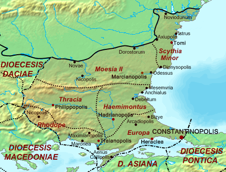
| Beschrijving | Map of the Diocese of Thrace (Dioecesis Thraciae) ca. 400 AD, showing the subordinate provinces and the major cities. |
| Datum | |
| Bron |
Base map found at en:Topographic map#Global 1-kilometer map, otherwise self-made. Data based on maps in atlases and the internet and on contemporary sources, primarily the Notitia Dignitatum. Note: The exact course of the provincial boundaries is very uncertain and in many cases only approximate. |
| Auteur | Cplakidas |
Licentie
| Ik, de auteursrechthebbende van dit werk, geef dit werk vrij in het publieke domein. Dit is wereldwijd van toepassing. In sommige landen is dit wettelijk niet mogelijk; in die gevallen geldt: Ik sta iedereen toe dit werk voor eender welk doel te gebruiken, zonder enige voorwaarden, tenzij zulke voorwaarden door de wet worden voorgeschreven. |
Bestandsgeschiedenis
Klik op een datum/tijd om het bestand te zien zoals het destijds was.
| Datum/tijd | Miniatuur | Afmetingen | Gebruiker | Opmerking | |
|---|---|---|---|---|---|
| huidige versie | 20 mei 2017 16:30 | | 461 × 352 (205 kB) | Julieta39 | Antic shoreline of the Danube mouths since Grigore Antipa's "Black Sea" (1940) and Andrei Nacu's paleomap [https://fr.wikipedia.org/wiki/Delta_du_Danube#/media/File:Danube_Delta_evolution.gif]. |
| 2 okt 2007 18:25 |  | 461 × 352 (139 kB) | Cplakidas | {{Information |Description=Map of the Diocese of Thrace (''Dioecesis Thraciae'') ca. 400 AD, showing the subordinate provinces and the major cities. |Source=Base map found at en:Topographic map#Global 1-kilometer map, other |
Bestandsgebruik
Dit bestand wordt op de volgende 2 pagina's gebruikt:
Globaal bestandsgebruik
De volgende andere wiki's gebruiken dit bestand:
- Gebruikt op an.wikipedia.org
- Gebruikt op ar.wikipedia.org
- Gebruikt op arz.wikipedia.org
- Gebruikt op az.wikipedia.org
- Gebruikt op be.wikipedia.org
- Gebruikt op bg.wikipedia.org
- Gebruikt op ca.wikipedia.org
- Gebruikt op cs.wikipedia.org
- Gebruikt op da.wikipedia.org
- Gebruikt op de.wikipedia.org
- Gebruikt op de.wikivoyage.org
- Gebruikt op el.wikipedia.org
- Gebruikt op en.wikipedia.org
- Gebruikt op es.wikipedia.org
Globaal gebruik van dit bestand bekijken.