
Bestand:Donner route map.png
Grootte van deze voorvertoning: 800 × 261 pixels. Andere resoluties: 320 × 104 pixels | 640 × 208 pixels | 1.024 × 334 pixels | 3.070 × 1.000 pixels.
Oorspronkelijk bestand (3.070 × 1.000 pixels, bestandsgrootte: 4,05 MB, MIME-type: image/png)
| Dit is een bestand van Wikimedia Commons. Onderstaande beschrijving komt van de beschrijving van het bestand daar. |
Beschrijving
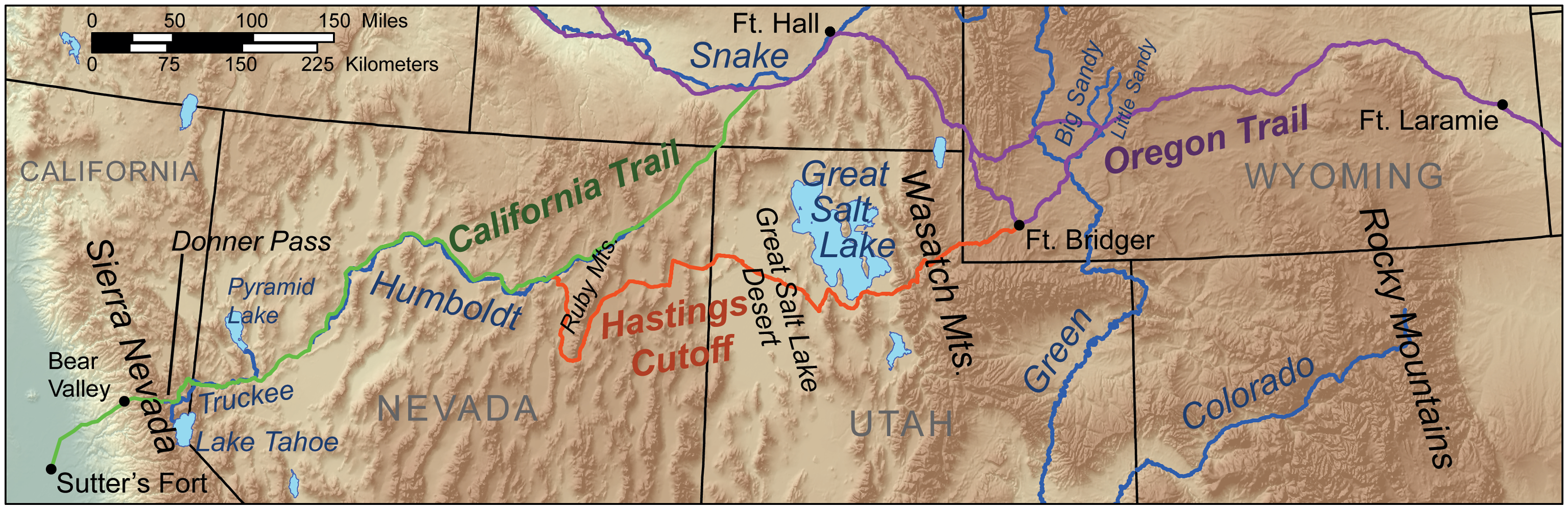
| Beschrijving | Map showing the route taken by the Donner Party. |
| Datum | |
| Bron | Eigen werk, Elevation data from SRTM, Trails data from the NPS [1], all other features from the National Atlas. |
| Auteur | Kmusser (overleg · bijdragen) |
| Andere versies |
Licentie
Ik, de auteursrechthebbende van dit werk, maak het hierbij onder de volgende licentie beschikbaar:
Dit bestand is gelicenseerd onder de Creative Commons-licentie Naamsvermelding-Gelijk delen 3.0 Unported
- De gebruiker mag:
- Delen – het werk kopiëren, verspreiden en doorgeven
- Remixen – afgeleide werken maken
- Onder de volgende voorwaarden:
- naamsvermelding – U moet op een gepaste manier aan naamsvermelding doen, een link naar de licentie geven, en aangeven of er wijzigingen in het werk zijn aangebracht. U mag dit op elke redelijke manier doen, maar niet zodanig dat de indruk wordt gewekt dat de licentiegever instemt met uw werk of uw gebruik van zijn werk.
- Gelijk delen – Als u het werk heeft geremixt, veranderd, of erop heeft voortgebouwd, moet u het gewijzigde materiaal verspreiden onder dezelfde licentie als het oorspronkelijke werk, of een daarmee compatibele licentie.
Bestandsgeschiedenis
Klik op een datum/tijd om het bestand te zien zoals het destijds was.
| Datum/tijd | Miniatuur | Afmetingen | Gebruiker | Opmerking | |
|---|---|---|---|---|---|
| huidige versie | 29 mrt 2010 18:59 | 3.070 × 1.000 (4,05 MB) | Kmusser | added cutoff | |
| 22 mrt 2010 17:11 | 3.070 × 1.000 (4,05 MB) | Kmusser | added scale bar | ||
| 19 mrt 2010 15:19 | 3.070 × 1.000 (4,05 MB) | Kmusser | {{Information |Description=Map showing the route taken by the w:Donner Party. |Source={{own}}, Elevation data from SRTM, Trails data from the NPS [http://www.nps.gov/cali/planyourvi |
Bestandsgebruik
Dit bestand wordt op de volgende pagina gebruikt:
Globaal bestandsgebruik
De volgende andere wiki's gebruiken dit bestand:
- Gebruikt op ca.wikipedia.org
- Gebruikt op cs.wikipedia.org
- Gebruikt op en.wikipedia.org
- Gebruikt op es.wikipedia.org
- Gebruikt op fa.wikipedia.org
- Gebruikt op hu.wikipedia.org
- Gebruikt op it.wikipedia.org
- Gebruikt op ja.wikipedia.org
- Gebruikt op no.wikipedia.org
- Gebruikt op pl.wikipedia.org
- Gebruikt op pt.wikipedia.org
- Gebruikt op ro.wikipedia.org
- Gebruikt op ru.wikipedia.org
- Gebruikt op zh.wikipedia.org