
Bestand:EEZ France.png
Grootte van deze voorvertoning: 800 × 391 pixels. Andere resoluties: 320 × 156 pixels | 640 × 313 pixels | 1.024 × 501 pixels | 1.280 × 626 pixels | 2.410 × 1.178 pixels.
Oorspronkelijk bestand (2.410 × 1.178 pixels, bestandsgrootte: 317 kB, MIME-type: image/png)
| Dit is een bestand van Wikimedia Commons. Onderstaande beschrijving komt van de beschrijving van het bestand daar. |
Beschrijving

|
Bestand:Territorial waters - France.svg is een vectorversie van dit bestand. Deze dient gebruikt te worden in plaats van deze rasterafbeelding.
File:EEZ France.png → File:Territorial waters - France.svg
Zie Help:SVG voor meer informatie. |
 |
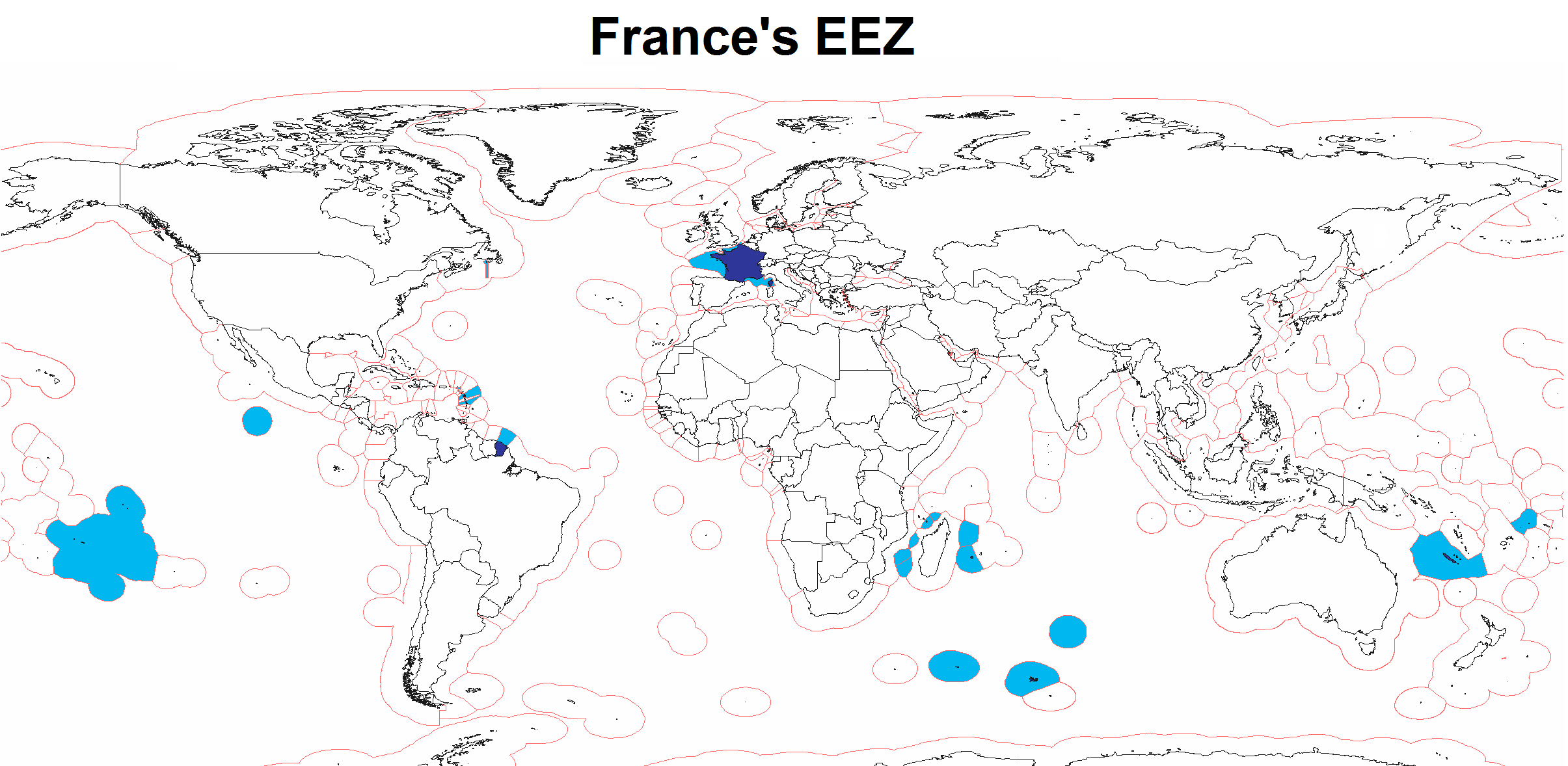
| Beschrijving | Map of France's Exclusive Economic Zone |
| Datum | |
| Bron | Eigen werk |
| Auteur | Godefroy |
| Andere versies | Afgeleide werken van dit bestand: WorldEEZ.png |
Licentie
Ik, de auteursrechthebbende van dit werk, maak het hierbij onder de volgende licenties beschikbaar:

|
Toestemming wordt verleend voor het kopiëren, verspreiden en/of wijzigen van dit document onder de voorwaarden van de GNU-licentie voor vrije documentatie, versie 1.2 of enige latere versie als gepubliceerd door de Free Software Foundation; zonder Invariant Sections, zonder Front-Cover Texts, en zonder Back-Cover Texts. Een kopie van de licentie is opgenomen in de sectie GNU-licentie voor vrije documentatie. |
| Dit bestand is gelicenseerd onder de Creative Commons-licentie Naamsvermelding-Gelijk delen 3.0 Unported | ||
| ||
| Deze licentietag is toegevoegd aan dit bestand in verband met de GFDL licentie-update. |
U mag zelf één van de licenties kiezen.
Bestandsgeschiedenis
Klik op een datum/tijd om het bestand te zien zoals het destijds was.
| Datum/tijd | Miniatuur | Afmetingen | Gebruiker | Opmerking | |
|---|---|---|---|---|---|
| huidige versie | 25 jul 2020 16:45 | | 2.410 × 1.178 (317 kB) | Maphobbyist | Added the borders of South Sudan and Montengro, and the Sea of Okhotsk is now wholly within the Russian EEZ. |
| 3 feb 2010 07:16 |  | 2.410 × 1.178 (289 kB) | Insider | little correction | |
| 17 mrt 2008 17:33 |  | 2.410 × 1.178 (183 kB) | Godefroy~commonswiki | {{Information |Description=Map of France's EEZ |Source=self-made |Date=March 17, 2008 |Author= Godefroy |Permission= |other_versions= }} |
Bestandsgebruik
Geen enkele pagina gebruikt dit bestand.
Globaal bestandsgebruik
De volgende andere wiki's gebruiken dit bestand:
- Gebruikt op en.wikibooks.org
- Gebruikt op fr.wikipedia.org
- Gebruikt op fr.wikiversity.org
- Gebruikt op hy.wikipedia.org
- Gebruikt op id.wikipedia.org
- Gebruikt op it.wikipedia.org
- Gebruikt op kn.wikipedia.org
- Gebruikt op mk.wikipedia.org
- Gebruikt op nn.wikipedia.org
- Gebruikt op ro.wikibooks.org
- Gebruikt op te.wikipedia.org
- Gebruikt op www.wikidata.org