
Bestand:Empire colonial français (1920).png

Grootte van deze voorvertoning: 800 × 351 pixels. Andere resoluties: 320 × 140 pixels | 640 × 281 pixels | 1.425 × 625 pixels.
Oorspronkelijk bestand (1.425 × 625 pixels, bestandsgrootte: 38 kB, MIME-type: image/png)
| Dit is een bestand van Wikimedia Commons. Onderstaande beschrijving komt van de beschrijving van het bestand daar. |
.png)

|
Deze kaartafbeelding zou opnieuw moeten worden aangemaakt als een SVG-bestand door vectorafbeeldingen te gebruiken. Dit heeft een aantal voordelen; zie Commons:Media for cleanup voor meer informatie. Als er een SVG-formaat van deze afbeelding bestaat, dan deze graag uploaden. Nadat u dit heeft gedaan, gelieve dit sjabloon te vervangen door het sjabloon {{vector version available|nieuwe bestandsnaam.svg}} op deze afbeeldingspagina.
|
Beschrijving
| Beschrijving |
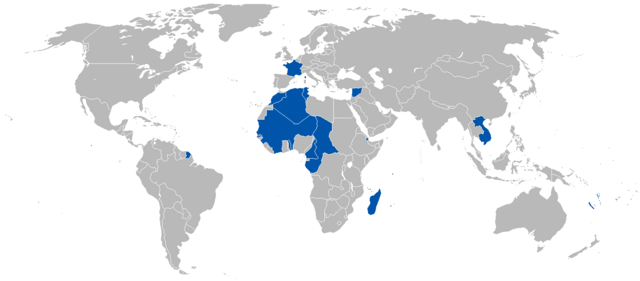
Русский: Французская колониальная империя в 1920 году English: A map of the French Colonial Empire in 1920. |
||
| Datum | Uploaded on 27 augustus 2008, 21:41. | ||
| Bron | Eigen werk. | ||
| Auteur | Vadac. | ||
| Toestemming (Hergebruik van dit bestand) |
|
||
| Andere versies | File:British and French empires 1920.png |
Bestandsgeschiedenis
Klik op een datum/tijd om het bestand te zien zoals het destijds was.
| Datum/tijd | Miniatuur | Afmetingen | Gebruiker | Opmerking | |
|---|---|---|---|---|---|
| huidige versie | 16 jul 2023 01:52 | | 1.425 × 625 (38 kB) | Randomastwritter | added jubaland |
| 7 mei 2011 20:51 |  | 1.425 × 625 (49 kB) | Quigley | Correct to be more in line with China's internationally recognized borders at the time | |
| 13 okt 2010 03:52 |  | 1.425 × 625 (49 kB) | Vadac | Corrected borders | |
| 12 apr 2008 12:33 |  | 1.357 × 628 (45 kB) | Votolom | {{Information |Description=Map of the French colonial empire at its peak. Territory shown as of 1920, although the empire was roughly the same size from 1905-1960. |Licence={{GFDL-self}} |Date=2008 |Author=User:Votolom }} |
Bestandsgebruik
Dit bestand wordt op de volgende pagina gebruikt:
Globaal bestandsgebruik
De volgende andere wiki's gebruiken dit bestand:
- Gebruikt op af.wikipedia.org
- Gebruikt op de.wikipedia.org
- Gebruikt op en.wikipedia.org
- Gebruikt op en.wikivoyage.org
- Gebruikt op eo.wikipedia.org
- Gebruikt op eu.wikipedia.org
- Gebruikt op frr.wikipedia.org
- Gebruikt op hy.wikipedia.org
- Gebruikt op id.wikipedia.org
- Gebruikt op ko.wikipedia.org
- Gebruikt op pl.wikipedia.org
- Gebruikt op pt.wikipedia.org
- Gebruikt op zh.wikipedia.org
.png)