
Bestand:EspañaLoc.svg

Afmetingen van deze voorvertoning van het type PNG van dit SVG-bestand: 800 × 457 pixels Andere resoluties: 320 × 183 pixels | 640 × 366 pixels | 1.024 × 585 pixels | 1.280 × 731 pixels | 2.560 × 1.462 pixels | 3.300 × 1.885 pixels.
Oorspronkelijk bestand (SVG-bestand, nominaal 3.300 × 1.885 pixels, bestandsgrootte: 1,9 MB)
| Dit is een bestand van Wikimedia Commons. Onderstaande beschrijving komt van de beschrijving van het bestand daar. |
Beschrijving
| Beschrijving |
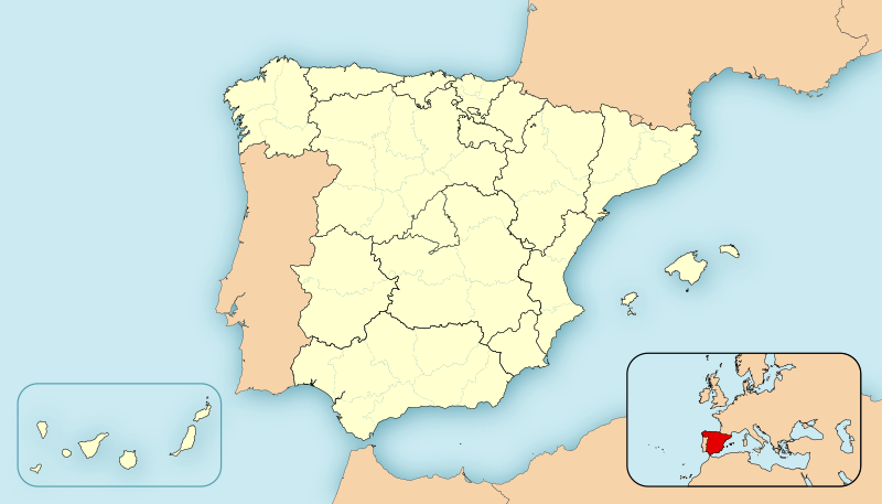
English: Location map of Spain
Equirectangular projection, N/S stretching 130 %. Geographic limits of the map:
Español: Mapa de localización de España
Proyección cilíndrica equidistante, N/S estirada 130 %. Límites geográficos del mapa:
|
|
| Datum | ||
| Bron | Eigen werk | |
| Auteur | HansenBCN | |
| Andere versies |
Afgeleide werken van dit bestand: |
|
| SVG ontwikkeling | De broncode van dit SVG-bestand is deugdelijk.
|


Licentie
| Ik, de auteursrechthebbende van dit werk, geef dit werk vrij in het publieke domein. Dit is wereldwijd van toepassing. In sommige landen is dit wettelijk niet mogelijk; in die gevallen geldt: Ik sta iedereen toe dit werk voor eender welk doel te gebruiken, zonder enige voorwaarden, tenzij zulke voorwaarden door de wet worden voorgeschreven. |
Bestandsgeschiedenis
Klik op een datum/tijd om het bestand te zien zoals het destijds was.
| Datum/tijd | Miniatuur | Afmetingen | Gebruiker | Opmerking | |
|---|---|---|---|---|---|
| huidige versie | 8 dec 2010 14:22 | | 3.300 × 1.885 (1,9 MB) | Miguillen | quito bordes |
| 24 nov 2010 16:33 |  | 3.300 × 1.885 (1,9 MB) | Miguillen | no se ve. y abriendo la imagen en inkscape veo que se ha vandalizado | |
| 24 nov 2010 16:23 |  | 3.300 × 1.885 (777 kB) | Mutxamel | Borders | |
| 15 feb 2010 03:28 |  | 3.300 × 1.885 (1,9 MB) | Miguillen | Reverted to version as of 09:28, 27 April 2008 | |
| 13 feb 2010 17:50 |  | 3.300 × 1.885 (1,63 MB) | Malus Catulus | Removed fancy shadow effect which is un-standard | |
| 27 apr 2008 11:28 |  | 3.300 × 1.885 (1,9 MB) | HansenBCN | Sombreado de agua - desplazado - y fronteras provinciales más tenues | |
| 26 apr 2008 21:23 |  | 3.300 × 1.885 (1,89 MB) | HansenBCN | +fronteras provinciales | |
| 26 apr 2008 16:39 |  | 3.300 × 1.885 (967 kB) | HansenBCN | Bordes | |
| 26 apr 2008 16:34 |  | 3.300 × 1.885 (967 kB) | HansenBCN | == Summary == {{Information |Description=Spain Location Map |Source=self-made |Date=26/april/2008 |Author= HansenBCN |Permission= |other_versions=50px }} == Licensing == {{PD-self}} |
Bestandsgebruik
Geen enkele pagina gebruikt dit bestand.
Globaal bestandsgebruik
De volgende andere wiki's gebruiken dit bestand:
- Gebruikt op ar.wikipedia.org
- Gebruikt op azb.wikipedia.org
- Gebruikt op br.wikipedia.org
- Gebruikt op ca.wikipedia.org
- Gebruikt op cbk-zam.wikipedia.org
- Gebruikt op eml.wikipedia.org
- Gebruikt op en.wikipedia.org
- Gebruikt op eo.wikipedia.org
- Gebruikt op es.wikipedia.org
Globaal gebruik van dit bestand bekijken.