
Bestand:Flusssystemkarte Rhein 06.jpg

Grootte van deze voorvertoning: 441 × 599 pixels. Andere resoluties: 177 × 240 pixels | 353 × 480 pixels | 565 × 768 pixels | 754 × 1.024 pixels | 1.508 × 2.048 pixels | 3.198 × 4.343 pixels.
Oorspronkelijk bestand (3.198 × 4.343 pixels, bestandsgrootte: 11,74 MB, MIME-type: image/jpeg)
| Dit is een bestand van Wikimedia Commons. Onderstaande beschrijving komt van de beschrijving van het bestand daar. |
Beschrijving
| Beschrijving |
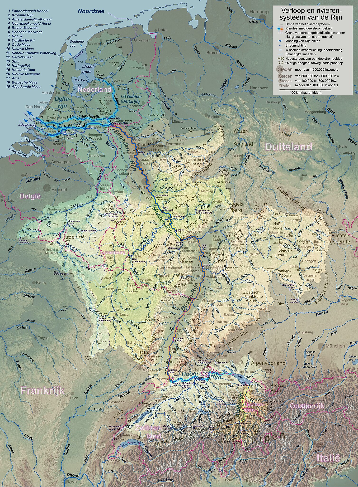
English: Rhine course and river system, place names in dutch Deutsch: Rheinlauf und Flusssystem, niederländisch beschriftet Français : Cours du Rhin et son bassin versant, noms de lieux en néerlandais Nederlands: Verloop en rivierensysteem van de Rijn, plaatsnamen in Nederlands |
| Datum | |
| Bron | Eigen werk |
| Auteur | WWasser |
| Andere versies | Versions in german, english, french, or with local names. For other languages the unlabelled version may be used. There are also less detailed maps of the river system with either german, english, french, dutch, or local names. A small version without names is available, too. |
| Cameralocatie | | Deze en andere afbeeldingen in: OpenStreetMap |
|---|
- Background relief created with Google Maps-For-Free SRTM3 Webserver
- Topography derived from Open Street Map
- Outlines of catchment areas derived from relief data (in the Netherlands also taken from several ICPR (International Commission for the Protection of the Rhine)- and Rijkswaterstaat-publications)
Licentie
Ik, de auteursrechthebbende van dit werk, maak het hierbij onder de volgende licentie beschikbaar:
Dit bestand is gelicenseerd onder de Creative Commons-licentie Naamsvermelding-Gelijk delen 3.0 Unported
- De gebruiker mag:
- Delen – het werk kopiëren, verspreiden en doorgeven
- Remixen – afgeleide werken maken
- Onder de volgende voorwaarden:
- naamsvermelding – U moet op een gepaste manier aan naamsvermelding doen, een link naar de licentie geven, en aangeven of er wijzigingen in het werk zijn aangebracht. U mag dit op elke redelijke manier doen, maar niet zodanig dat de indruk wordt gewekt dat de licentiegever instemt met uw werk of uw gebruik van zijn werk.
- Gelijk delen – Als u het werk heeft geremixt, veranderd, of erop heeft voortgebouwd, moet u het gewijzigde materiaal verspreiden onder dezelfde licentie als het oorspronkelijke werk, of een daarmee compatibele licentie.
Bestandsgeschiedenis
Klik op een datum/tijd om het bestand te zien zoals het destijds was.
| Datum/tijd | Miniatuur | Afmetingen | Gebruiker | Opmerking | |
|---|---|---|---|---|---|
| huidige versie | 17 sep 2017 20:29 | | 3.198 × 4.343 (11,74 MB) | WWasser | Albertkanaal, Aa (Dommel), frontier lines in Lake of Constance |
| 18 apr 2013 15:37 |  | 2.399 × 3.255 (4,71 MB) | WWasser | some more details | |
| 4 apr 2013 18:47 |  | 2.131 × 2.893 (4,23 MB) | WWasser | {{Information |Description ={{en|1=legend and colours improved, more toponyms translated}} |Source =own work |Author =Wolfgang Wasser |Date = |Permission = |other_versions = }} | |
| 5 mrt 2013 16:21 |  | 2.131 × 2.894 (3,32 MB) | WWasser | some smaller rivers, elevations | |
| 8 feb 2013 14:51 |  | 2.131 × 2.894 (2,98 MB) | WWasser | {{Information |Description ={{en|1=colours improved}} |Source =own |Author =WWasser |Date = |Permission = |other_versions = }} | |
| 7 feb 2013 16:28 |  | 2.131 × 2.894 (3 MB) | WWasser | resolution reduced | |
| 5 feb 2013 18:05 |  | 4.263 × 5.791 (4,22 MB) | WWasser | User created page with UploadWizard |
Bestandsgebruik
Dit bestand wordt op de volgende 2 pagina's gebruikt:
Globaal bestandsgebruik
De volgende andere wiki's gebruiken dit bestand: