
Bestand:Franklin battle 1630.png

Grootte van deze voorvertoning: 551 × 600 pixels. Andere resoluties: 220 × 240 pixels | 441 × 480 pixels | 705 × 768 pixels | 941 × 1.024 pixels | 2.401 × 2.614 pixels.
Oorspronkelijk bestand (2.401 × 2.614 pixels, bestandsgrootte: 3,03 MB, MIME-type: image/png)
| Dit is een bestand van Wikimedia Commons. Onderstaande beschrijving komt van de beschrijving van het bestand daar. |
Beschrijving
| Beschrijving |
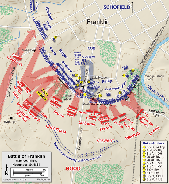
English: Map of the Battle of Franklin of the American Civil War, showing the Union defensive lines at 4:30 PM. Drawn in Adobe Illustrator CC by Hal Jespersen. Graphic source file is available at https://www.cwmaps.com/freemaps.html |
| Datum | |
| Bron | Eigen werk |
| Auteur | Hal Jespersen at en.wikipedia |
Licentie
Hal Jespersen at en.wikipedia, de auteursrechthebbende van dit werk, maakt het hierbij onder de volgende licentie beschikbaar:
Dit bestand is gelicenseerd onder de Creative Commons-licentie Naamsvermelding 3.0 Unported
Naamsvermelding: Map by Hal Jespersen, www.cwmaps.com
- De gebruiker mag:
- Delen – het werk kopiëren, verspreiden en doorgeven
- Remixen – afgeleide werken maken
- Onder de volgende voorwaarden:
- naamsvermelding – U moet op een gepaste manier aan naamsvermelding doen, een link naar de licentie geven, en aangeven of er wijzigingen in het werk zijn aangebracht. U mag dit op elke redelijke manier doen, maar niet zodanig dat de indruk wordt gewekt dat de licentiegever instemt met uw werk of uw gebruik van zijn werk.
Oorspronkelijk uploadlogboek
De oorspronkelijke beschrijving van deze afbeelding stond hier. Alle volgende gebruikersnamen verwijzen naar en.wikipedia.
- 2010-01-15 22:48 Hlj 1911×1127× (383472 bytes) Minor corrections to west end of line. {{cc-by-3.0|Map by Hal Jespersen, www.posix.com/CW}}
- 2010-01-06 23:46 Hlj 1911×1127× (383157 bytes) Corrected Union positions east of the Columbia Pike. {{cc-by-3.0|Map by Hal Jespersen, www.posix.com/CW}}
- 2010-01-03 00:10 Hlj 1911×1127× (362145 bytes) {{Information |Description=Map of the [[Battle of Franklin]] of the [[American Civil War]], showing the Union defensive lines at 4:30 PM. Drawn in Adobe Illustrator CS3 by Hal Jespersen. Graphic source file is available at http://www.posix.com/CWmaps/ |So
Bestandsgeschiedenis
Klik op een datum/tijd om het bestand te zien zoals het destijds was.
| Datum/tijd | Miniatuur | Afmetingen | Gebruiker | Opmerking | |
|---|---|---|---|---|---|
| huidige versie | 15 feb 2021 21:02 | | 2.401 × 2.614 (3,03 MB) | Hlj | improve background accuracy of my previous map |
| 19 dec 2013 21:23 |  | 3.849 × 2.256 (1,31 MB) | Hlj | Corrected brigade alignment in Loring's division. Cleaned up some attack arrows. Same license. | |
| 16 mrt 2011 20:00 |  | 1.924 × 1.128 (583 kB) | Hlj | Improve the accuracy of Union retreats and counterattacks. Minor graphical changes to adopt new style of roads and water. Same license. | |
| 13 nov 2010 17:02 |  | 1.924 × 1.128 (560 kB) | Hlj | Oops, correct the date again. | |
| 13 nov 2010 17:00 |  | 1.924 × 1.128 (560 kB) | Hlj | Corrected date in legend. Same license. | |
| 15 feb 2010 02:46 |  | 1.911 × 1.127 (544 kB) | Hlj | Update to include brigade and division commander, Confederate attacks. Same license. | |
| 24 jan 2010 17:15 |  | 1.911 × 1.127 (374 kB) | BotMultichill | {{BotMoveToCommons|en.wikipedia|year={{subst:CURRENTYEAR}}|month={{subst:CURRENTMONTHNAME}}|day={{subst:CURRENTDAY}}}} {{Information |Description={{en|Map of the en:Battle of Franklin of the en:American Civil War, showing the Union defensive |
Bestandsgebruik
Dit bestand wordt op de volgende 2 pagina's gebruikt:
Globaal bestandsgebruik
De volgende andere wiki's gebruiken dit bestand:
- Gebruikt op de.wikipedia.org
- Gebruikt op en.wikipedia.org
- Patrick Cleburne
- Battle of Franklin
- Franklin–Nashville campaign
- John S. Casement
- 88th Illinois Infantry Regiment
- 65th Illinois Infantry Regiment
- 33rd Alabama Infantry Regiment
- Bridges' Battery Illinois Light Artillery
- 44th Missouri Infantry Regiment (Union)
- 12th Louisiana Infantry Regiment (Confederate)
- Gebruikt op es.wikipedia.org
- Gebruikt op fr.wikipedia.org
- Gebruikt op it.wikipedia.org