
Bestand:Gwash map02.jpg
Oorspronkelijk bestand (3.227 × 2.390 pixels, bestandsgrootte: 1,77 MB, MIME-type: image/jpeg)
| Dit is een bestand van Wikimedia Commons. Onderstaande beschrijving komt van de beschrijving van het bestand daar. |
Beschrijving
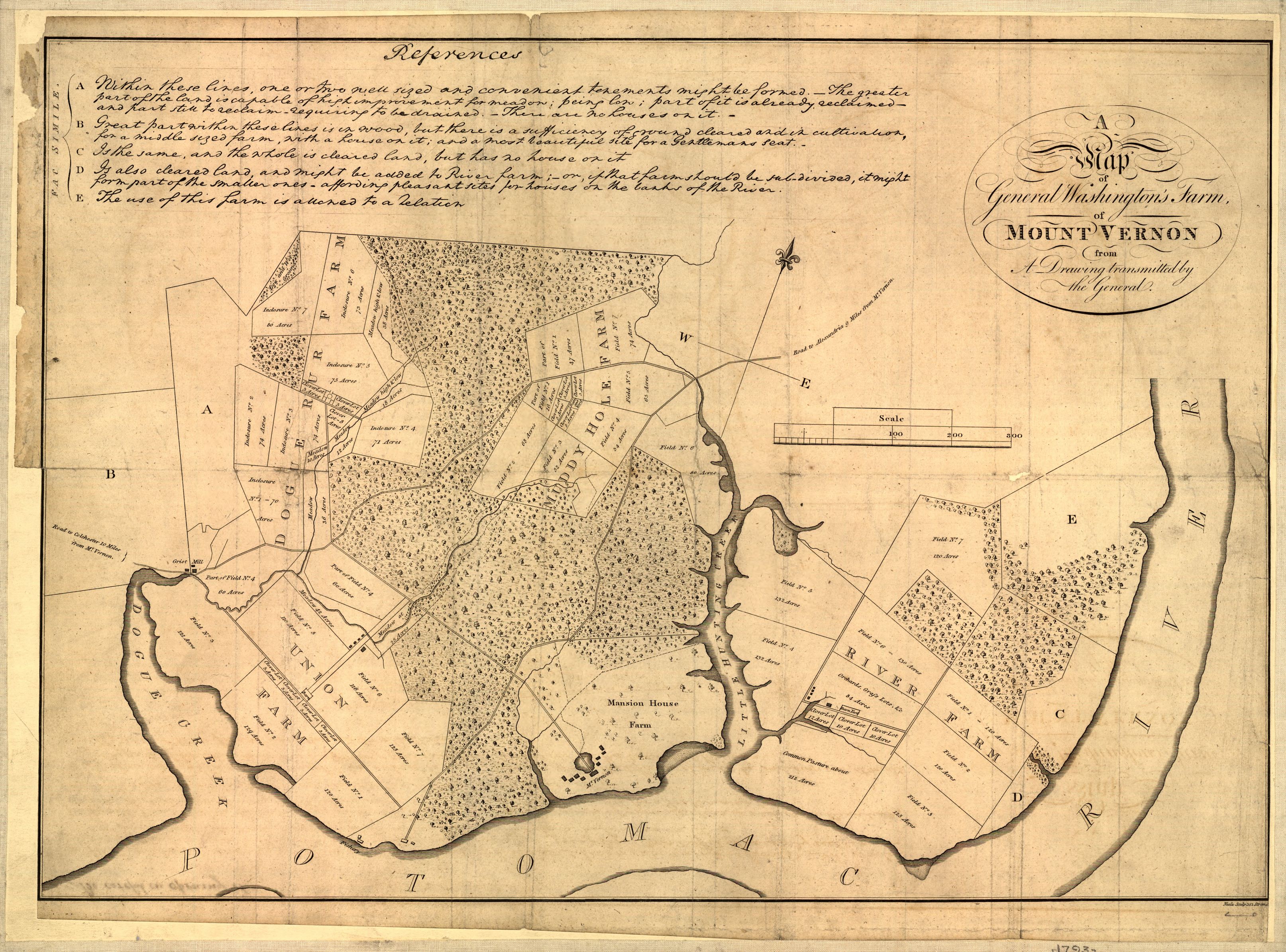
Map of Mount Vernon, residence of George Washington made by himself.
A map of General Washington's farm of Mount Vernon from a drawing transmitted by the General.
Uploaded from http://hdl.loc.gov/loc.gmd/g3882m.ct000367.
Notes from Library of Congress page:
CREATED/PUBLISHED [S.l., 1801]
NOTES Removed from: Letters from His Excellency George Washington, to Arthur Young, [etc.]. London, 1801. Opp. p. (E312.75.A27 Rare Book Rm.)
Scale 1:6,336.
SUBJECTS Mount Vernon (Va. : Estate)--Maps--Early works to 1800. United States--Virginia--Mount Vernon (Estate)
MEDIUM 1 map ; 37 x 52 cm.
CALL NUMBER G3882.M7 1793 .W34 1801 TIL Vault
REPOSITORY Library of Congress Geography and Map Division Washington, D.C. 20540-4650
DIGITAL ID g3882m ct000367

|
Dit bestand is beschikbaar in de Geography & Map Division van de Library of Congress
via digitaal ID g3882m.ct000367. Deze banner zegt niets over de auteursrechten die van toepassing zijn. Een normale auteursrechten-tag is nodig. Zie Commons:Licensing voor meer informatie.
|
Licentie
|
Dit werk bevindt zich in het publiek domein in landen en gebieden waar de auteursrechttermijn het leven van de auteur plus 70 jaar of minder is.
| |
| Van dit bestand is vastgesteld dat er geen bekende auteursrechtaanspraken op rusten, alle aanverwante en naburige rechten daarbij inbegrepen. | |
Bestandsgeschiedenis
Klik op een datum/tijd om het bestand te zien zoals het destijds was.
| Datum/tijd | Miniatuur | Afmetingen | Gebruiker | Opmerking | |
|---|---|---|---|---|---|
| huidige versie | 1 okt 2006 04:17 | | 3.227 × 2.390 (1,77 MB) | Clindberg | Reupload from http://hdl.loc.gov/loc.gmd/g3882m.ct000367 with higher resolution; change license (not USGov but is PD-old) |
| 6 jun 2005 15:01 |  | 804 × 600 (138 kB) | Herrick~commonswiki | Map of Mount Vernon, residence of George Washington made by himself. A map of General Washington's farm of Mount Vernon from a drawing transmitted by the General. {{PD-USGov}} Washington, George, 1732-1799. CREATED/PUBLISHED [S.l., 1801] NOTES |
Bestandsgebruik
Dit bestand wordt op de volgende pagina gebruikt:
Globaal bestandsgebruik
De volgende andere wiki's gebruiken dit bestand:
- Gebruikt op de.wikipedia.org
- Gebruikt op en.wikipedia.org
- Gebruikt op fr.wikipedia.org
- Gebruikt op it.wikipedia.org
- Gebruikt op ja.wikipedia.org
- Gebruikt op ko.wikipedia.org
- Gebruikt op pt.wikipedia.org