Bestand:Hindu Kush satellite image.jpg

Pagina-inhoud wordt niet ondersteund in andere talen.
Uit Wikipedia, de vrije encyclopedie

Oorspronkelijk bestand(5.600 × 4.400 pixels, bestandsgrootte: 5,01 MB, MIME-type: image/jpeg)


Beschrijving

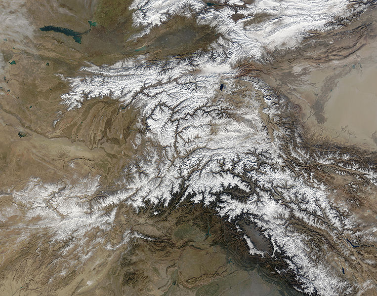
Beschrijving The Hindu Kush occupies the lower-left-center of this true-color MODIS satellite image, acquired 28 November 2003.
Datum
Bron NASA's Earth Observatory
Auteur Jeff Schmaltz, MODIS Land Rapid Response Team at NASA GSFC
Toestemming
(Hergebruik van dit bestand)
Public domain - original work of NASA
Andere versies

Afgeleide werken van dit bestand:  High Asia Mountain Ranges.jpg

Earth Observatory text: [1]

Once used by Alexander the Great in his effort to conquer the known world, the high-altitude passes of the Hindu Kush remain important trade and travel routes. Glaciers and heavy snowfall are ever-present features of these mountains, which rise to 7,692 meters (26,236 feet) in height.

Straddling the borders between Pakistan, Afghanistan, and India, the Hindu Kush is heavily populated. Though the valleys are heavily irrigated, growing crops at such high altitudes and low temperatures is difficult. The residents also have to worry about earthquakes, which are common as the Eurasian and Indo-Australian tectonic plates continue to push against one-another. This constant pressure and grinding create an average of four major (measuring at least 5 on the Richter scale) earthquakes a year.

In this true-color Terra Moderate Resolution Imaging Spectroradiometer (MODIS) image, the Hindu Kush occupies the lower-left-center of the image. To the left are the relatively lower altitude plains of southern Kazakhstan, Uzbekistan, Turkmenistan, Afghanistan, and Pakistan. The fertile plains surrounding the northern strands of the Indus River are a deep green at the bottom center of the image (a translucent veil of smog adds a gray tinge to the region). Straddling the mountains north of the Kush are Kyrgyzstan and Tajikistan, which butt up against the arid Tarim basin of northwestern China. The Silk Road, the all-important trade route between China and Europe, runs through the Hindu Kush and this basin. This true-color Terra MODIS image was acquired on November 28, 2003.

Image courtesy Jeff Schmaltz, MODIS Land Rapid Response Team at NASA GSFC

Licentie

Public domain Dit bestand bevindt zich in het publiek domein, omdat het gemaakt is door de NASA. In de reproductierichtlijnen van de NASA staat dat "NASA-materiaal niet beschermd wordt door auteursrecht, tenzij anders vermeld".

(NASA copyright policy page of JPL Image Use Policy).

Waarschuwingen:
  • Het gebruik van logo's, insignes en emblemen van de NASA wordt beperkt door de Amerikaanse wet 14 CFR 1221.
  • Op de website van de NASA staat een groot aantal afbeeldingen van het Sovjet-/Russisch ruimteagentschap en andere niet-Amerikaanse ruimteagentschappen. Deze afbeeldingen bevinden zich niet noodzakelijk in het publieke domein.
  • Materiaal dat gebaseerd is op gegevens van de ruimtetelescoop Hubble wordt mogelijk beschermd door auteursrecht als dit niet expliciet vervaardigd is door het STScI [2]. Zie tevens {{PD-Hubble}} en {{Cc-Hubble}} of {{Spacetelescope.org}}.
  • Het gemeenschappelijk project van ESA en NASA betreffende de ruimtesonde SOHO suggereert dat al het materiaal dat gemaakt is door zijn ruimtesonde beschermd wordt door auteursrecht en dat toestemming vereist is voor commercieel niet-educatief gebruik. [3]
  • Afbeeldingen op de Astronomy Picture of the Day-website (APOD) worden mogelijk beschermd door auteursrecht. [4]

Bijschriften

Beschrijf in één regel wat dit bestand voorstelt

Items getoond in dit bestand

beeldt af

Bestandsgeschiedenis

Klik op een datum/tijd om het bestand te zien zoals het destijds was.

Datum/tijdMiniatuurAfmetingenGebruikerOpmerking
huidige versie6 jun 2006 06:39Miniatuurafbeelding voor de versie van 6 jun 2006 06:395.600 × 4.400 (5,01 MB)Avenue{{Information |Description=The Hindu Kush occupies the lower-left-center of this true-color MODIS satellite image, acquired 28 November 2003. |Source=[NASA's Earth Observatory http://earthobservatory.nasa.gov/Newsroom/NewImages/images.php3?img_id=16411] |

Dit bestand wordt op de volgende pagina gebruikt:

Globaal bestandsgebruik

De volgende andere wiki's gebruiken dit bestand:

Metadata