
Bestand:Karluk voyage map.png

Grootte van deze voorvertoning: 800 × 537 pixels. Andere resoluties: 320 × 215 pixels | 640 × 429 pixels | 1.002 × 672 pixels.
Oorspronkelijk bestand (1.002 × 672 pixels, bestandsgrootte: 198 kB, MIME-type: image/png)
| Dit is een bestand van Wikimedia Commons. Onderstaande beschrijving komt van de beschrijving van het bestand daar. |

|
Deze kaartafbeelding zou opnieuw moeten worden aangemaakt als een SVG-bestand door vectorafbeeldingen te gebruiken. Dit heeft een aantal voordelen; zie Commons:Media for cleanup voor meer informatie. Als er een SVG-formaat van deze afbeelding bestaat, dan deze graag uploaden. Nadat u dit heeft gedaan, gelieve dit sjabloon te vervangen door het sjabloon {{vector version available|nieuwe bestandsnaam.svg}} op deze afbeeldingspagina.
|
Beschrijving
| Beschrijving |
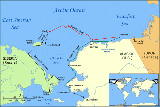
English: Map of the Voyage of the Karluk, including the outbound journey from Nome, the ship's drift in Arctic pack ice, the crew's icy march to Wrangel Island, and Captain Bartlett's journey on foot from Wrangel Island to Emma Harbor in Siberia, and then by ship to St. Michael, Alaska |
| Datum | |
| Bron |
Own work using:
|
| Auteur | Finetooth; NormanEinstein |
| Andere versies |
Afgeleide werken van dit bestand: |
Licentie
Ik, de auteursrechthebbende van dit werk, maak het hierbij onder de volgende licenties beschikbaar:

|
Toestemming wordt verleend voor het kopiëren, verspreiden en/of wijzigen van dit document onder de voorwaarden van de GNU-licentie voor vrije documentatie, versie 1.2 of enige latere versie als gepubliceerd door de Free Software Foundation; zonder Invariant Sections, zonder Front-Cover Texts, en zonder Back-Cover Texts. Een kopie van de licentie is opgenomen in de sectie GNU-licentie voor vrije documentatie. |
Dit bestand is gelicenseerd onder de Creative Commons-licentie Naamsvermelding-Gelijk delen 3.0 Unported
- De gebruiker mag:
- Delen – het werk kopiëren, verspreiden en doorgeven
- Remixen – afgeleide werken maken
- Onder de volgende voorwaarden:
- naamsvermelding – U moet op een gepaste manier aan naamsvermelding doen, een link naar de licentie geven, en aangeven of er wijzigingen in het werk zijn aangebracht. U mag dit op elke redelijke manier doen, maar niet zodanig dat de indruk wordt gewekt dat de licentiegever instemt met uw werk of uw gebruik van zijn werk.
- Gelijk delen – Als u het werk heeft geremixt, veranderd, of erop heeft voortgebouwd, moet u het gewijzigde materiaal verspreiden onder dezelfde licentie als het oorspronkelijke werk, of een daarmee compatibele licentie.
U mag zelf één van de licenties kiezen.
Bestandsgeschiedenis
Klik op een datum/tijd om het bestand te zien zoals het destijds was.
| Datum/tijd | Miniatuur | Afmetingen | Gebruiker | Opmerking | |
|---|---|---|---|---|---|
| huidige versie | 30 jan 2010 20:36 | | 1.002 × 672 (198 kB) | Finetooth | Added black border to left edge. |
| 28 jan 2010 04:33 |  | 1.002 × 672 (198 kB) | Finetooth | Added directional arrow to map scale | |
| 28 jan 2010 04:12 |  | 1.002 × 672 (198 kB) | Finetooth | Added map scale, moved Bering Sea text slightly to reduce clutter | |
| 28 jan 2010 04:12 |  | 1.002 × 672 (198 kB) | Finetooth | Added map scale, moved Bering Sea text slightly to reduce clutter | |
| 27 jan 2010 20:07 |  | 1.002 × 672 (195 kB) | Finetooth | Corrected placement of Port Clarence, moved Arctic Ocean and Beaufort Sea labels to the right and changed font to match East Siberian Sea | |
| 27 jan 2010 07:42 |  | 1.002 × 672 (184 kB) | Finetooth | Cropped, added colour to outward voyage and drift in ice, increased font size of voyage-segment text to improve readability, added Emma Town, Port Hope, Port Clarence, mouth of the Colville River, Herald Island and Herschel Island, made Bartlett's journey | |
| 26 jan 2010 05:11 |  | 1.200 × 672 (312 kB) | Finetooth | {{Information |Description={{en|1=Map of the Voyage of the ''Karluk'', including the outbound journey from Nome, the ship's drift in Arctic pack ice, the crew's icy march to Wrangel Island, and Captain Bartlett's journey on foot from Wrangel Island to Emm |
Bestandsgebruik
Dit bestand wordt op de volgende pagina gebruikt:
Globaal bestandsgebruik
De volgende andere wiki's gebruiken dit bestand:
- Gebruikt op en.wikipedia.org
- Gebruikt op fr.wikipedia.org
- Gebruikt op lv.wikipedia.org
- Gebruikt op pt.wikipedia.org
- Gebruikt op ru.wikipedia.org