
Bestand:Karte - Kesselschlacht bei Vjasma 1941.png

Grootte van deze voorvertoning: 583 × 600 pixels. Andere resoluties: 233 × 240 pixels | 467 × 480 pixels | 747 × 768 pixels | 1.047 × 1.077 pixels.
Oorspronkelijk bestand (1.047 × 1.077 pixels, bestandsgrootte: 338 kB, MIME-type: image/png)
| Dit is een bestand van Wikimedia Commons. Onderstaande beschrijving komt van de beschrijving van het bestand daar. |
Beschrijving
| Beschrijving |
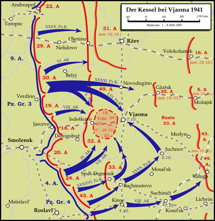
English: Map showing the Battle near Vyazma (October 2nd — October 20th 1941) during the Second World War (1939—1945) at the Eastern Front. The map is created by Inkscape and is based on the Map 30 in the attachement of the book P.N. Pospelow (Hrsg.): Geschichte des Großen Vaterländischen Krieges der Sowjetunion, Bd.2, Berlin (Ost) 1963. The troop movements have been corrected.
Deutsch: Karte der Kesselschlacht im Raum Vjasma (2. Oktober — 20. Oktober 1941) während des Zweiten Weltkrieges (1939—1945) an der Ostfront. Die Karte wurde mit Inkscape erstellt und basiert auf Karte Nr.30 aus dem Anhang des Buches P.N. Pospelow (Hrsg.): Geschichte des Großen Vaterländischen Krieges der Sowjetunion, Bd.2, Berlin (Ost) 1963. Die Truppenbewegungen wurden jedoch korrigiert. |
| Datum | |
| Bron | Eigen werk |
| Auteur | Memnon335bc |
Licentie
Ik, de auteursrechthebbende van dit werk, maak het hierbij onder de volgende licenties beschikbaar:
Dit bestand is gelicenseerd onder de Creative Commons-licentie Naamsvermelding-Gelijk delen 3.0 Unported
- De gebruiker mag:
- Delen – het werk kopiëren, verspreiden en doorgeven
- Remixen – afgeleide werken maken
- Onder de volgende voorwaarden:
- naamsvermelding – U moet op een gepaste manier aan naamsvermelding doen, een link naar de licentie geven, en aangeven of er wijzigingen in het werk zijn aangebracht. U mag dit op elke redelijke manier doen, maar niet zodanig dat de indruk wordt gewekt dat de licentiegever instemt met uw werk of uw gebruik van zijn werk.
- Gelijk delen – Als u het werk heeft geremixt, veranderd, of erop heeft voortgebouwd, moet u het gewijzigde materiaal verspreiden onder dezelfde licentie als het oorspronkelijke werk, of een daarmee compatibele licentie.

|
Toestemming wordt verleend voor het kopiëren, verspreiden en/of wijzigen van dit document onder de voorwaarden van de GNU-licentie voor vrije documentatie, versie 1.2 of enige latere versie als gepubliceerd door de Free Software Foundation; zonder Invariant Sections, zonder Front-Cover Texts, en zonder Back-Cover Texts. Een kopie van de licentie is opgenomen in de sectie GNU-licentie voor vrije documentatie. |
U mag zelf één van de licenties kiezen.
Bestandsgeschiedenis
Klik op een datum/tijd om het bestand te zien zoals het destijds was.
| Datum/tijd | Miniatuur | Afmetingen | Gebruiker | Opmerking | |
|---|---|---|---|---|---|
| huidige versie | 14 jan 2024 00:19 | | 1.047 × 1.077 (338 kB) | Андрей Романенко | some names and locations corrected |
| 1 jun 2015 00:01 |  | 1.047 × 1.077 (333 kB) | Cmdrjameson | Compressed with pngout. Reduced by 140kB (29% decrease). | |
| 14 sep 2009 00:53 |  | 1.047 × 1.077 (474 kB) | Memnon335bc | {{Information |Description={{en|1=Map showing the Battle near Vyazma (October 2nd — October 20th 1941) during the Second World War (1939—1945) at the Eastern Front. The map is created by Inkscape and is based on the Map 30 in the attachement of the bo |
Bestandsgebruik
Dit bestand wordt op de volgende pagina gebruikt:
Globaal bestandsgebruik
De volgende andere wiki's gebruiken dit bestand:
- Gebruikt op bg.wikipedia.org
- Gebruikt op de.wikipedia.org
- Gebruikt op en.wikipedia.org
- Gebruikt op et.wikipedia.org
- Gebruikt op fa.wikipedia.org
- Gebruikt op fi.wikipedia.org
- Gebruikt op he.wikipedia.org
- Gebruikt op it.wikipedia.org
- Gebruikt op mn.wikipedia.org
- Gebruikt op ru.wikipedia.org
- Gebruikt op tr.wikipedia.org
- Gebruikt op uk.wikipedia.org
- Gebruikt op vi.wikipedia.org
- Gebruikt op www.wikidata.org
- Gebruikt op zh.wikipedia.org