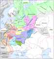
Bestand:Kievan Rus in 1237 (en).svg
Uiterlijk

Afmetingen van deze voorvertoning van het type PNG van dit SVG-bestand: 553 × 600 pixels Andere resoluties: 221 × 240 pixels | 442 × 480 pixels | 708 × 768 pixels | 944 × 1.024 pixels | 1.888 × 2.048 pixels | 1.204 × 1.306 pixels.
Oorspronkelijk bestand (SVG-bestand, nominaal 1.204 × 1.306 pixels, bestandsgrootte: 332 kB)
Bestandsgeschiedenis
Klik op een datum/tijd om het bestand te zien zoals het destijds was.
| Datum/tijd | Miniatuur | Afmetingen | Gebruiker | Opmerking | |
|---|---|---|---|---|---|
| huidige versie | 25 sep 2021 10:06 |  | 1.204 × 1.306 (332 kB) | Veverve | "Khvalisy" changed to to "Khvalis" |
| 9 apr 2021 21:16 |  | 1.204 × 1.306 (360 kB) | Veverve | "Principalty of Vladimir-Suzdal" corrected to "Principality of Vladimir-Suzdal" | |
| 16 mei 2020 19:04 |  | 1.204 × 1.306 (360 kB) | Goran tek-en | Named changed as requested by user:Veverve | |
| 12 feb 2020 19:39 |  | 1.204 × 1.306 (318 kB) | Goran tek-en | Changed name of Vladimir as requested bu Veverve | |
| 12 feb 2020 18:59 |  | 1.204 × 1.306 (317 kB) | Goran tek-en | {{Information |description ={{en|1=Map of the Kievan Rus in 1237. The nales of tribes and peoples are in brown, the names of countries outside the Kievan Rus are in black. The names of principalties of the Kievan Rus are in blue; if a principalty bears the a name which comes directly from the name of its capital (e.g. the Principalty of Kiev), the complete name of the paincipalty is not on the map and the capital name is in blue.}} |date =20200212 |source ={{Own}}<br>... |
Bestandsgebruik
Dit bestand wordt op de volgende pagina gebruikt:
Globaal bestandsgebruik
De volgende andere wiki's gebruiken dit bestand:
- Gebruikt op be.wikipedia.org
- Gebruikt op bg.wikipedia.org
- Gebruikt op ca.wikipedia.org
- Gebruikt op cy.wikipedia.org
- Gebruikt op da.wikipedia.org
- Gebruikt op de.wikipedia.org
- Gebruikt op en.wikipedia.org
- Gebruikt op es.wikipedia.org
- Gebruikt op hy.wikipedia.org
- Gebruikt op it.wikipedia.org
- Gebruikt op ja.wikipedia.org
- Gebruikt op ko.wikipedia.org
- Gebruikt op la.wikipedia.org
- Gebruikt op nn.wikipedia.org
- Gebruikt op no.wikipedia.org
- Gebruikt op pt.wikipedia.org
- Gebruikt op ro.wikipedia.org
- Gebruikt op rue.wikipedia.org
- Gebruikt op sw.wikipedia.org
- Gebruikt op tt.wikipedia.org
- Gebruikt op uk.wikipedia.org
- Gebruikt op www.wikidata.org
Globaal gebruik van dit bestand bekijken.


