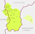
Bestand:Krahina e Gorës – (Gora region).svg

Pagina-inhoud wordt niet ondersteund in andere talen.
Uit Wikipedia, de vrije encyclopedie

Oorspronkelijk bestand(SVG-bestand, nominaal 6.436 × 6.253 pixels, bestandsgrootte: 172 kB)


Beschrijving

Beschrijving
Shqip: Krahina e Gorës
English: Gora region
  • Map of Gorani settlements and Gora region (green) and adjacent area in the Polog region (yellow) that is culturally and linguistically associated with the core region.


Gorani inhabited settlements in Albania and Kosovo are synonymous with the geographical outline of Gora as a region. (see: Bardhoshi, Nebi (2016) "Small Numbers, Big issues: The Border areas as Social Arena of Legal Systems" in Exchange, Dialogue, New Divisions?: Ethnic Groups and Political Cultures in Eastern Europe, LIT Verlag, p. 83. ISBN: 9783643802095. )

  • Albania:

Steinke, Klaus (2010) Die slavischen Minderheiten in Albanien (SMA). 3. Gora, München: Verlag Otto Sagner, p. 11. ISBN: 978-3-86688-112-9.

Schmidinger, Thomas (2013). Gora: Slawischsprachige Muslime zwischen Kosovo, Albanien, Mazedonien und Diaspora. Wiener Verlag. pp. 98-99. ISBN 9783944690049

  • Kosovo:

Schmidinger, Thomas (2013). Gora: Slawischsprachige Muslime zwischen Kosovo, Albanien, Mazedonien und Diaspora. Wiener Verlag. p. 65. ISBN 9783944690049

Schmidinger, Thomas (2018) "Forced return to empty villages: A case study of the Gorani in Kosovo" in Remigration to Post-Socialist Europe. Hopes and Realities of Return, Lit Verlag, p. 265. ISBN: 9783643910257.

  • North Macedonia (2 villages in the Polog region):

Koleva, Krasimira (2012) "Balkanisms today: The dialect of Župa (Kosovo)" in Balkanismen heute – Balkanisms today – Балканизмы сегодня, LIT Verlag, p. 351. ISBN: 9783643503886.

Rexhepi, Besnik; Mustafa, Behxhet; Hajdari, Avni; Rushidi-Rexhepi, Jehona; Quave, Cassandra L.; Pieroni, Andrea (2014). "Cross-cultural ethnobotany of the Sharr Mountains (northwestern Macedonia)". In Pieroni, Andrea; Quave, Cassandra L. (eds.). Ethnobotany and Biocultural Diversities in the Balkans. Springer. p. 70. ISBN 9781493914920


The boundaries of the region and its settlements shown in the map are based on the cadastral record. The following government based sources were used for the composition of the map.

  • Albania: Kukës County (map of Shishtavec unit [1]; map of Zapod unit [2])
  • Kosovo: Dragash Municipality covered in cadastral map [3]
  • North Macedonia: Bogovinje Municipality covered in cadastral map [4]
Datum
Bron Eigen werk
Auteur Resnjari

Licentie

Ik, de auteursrechthebbende van dit werk, maak het hierbij onder de volgende licentie beschikbaar:
w:nl:Creative Commons
naamsvermelding Gelijk delen
Dit bestand is gelicenseerd onder de Creative Commons Naamsvermelding-GelijkDelen 4.0 Internationaal licentie.
De gebruiker mag:
  • Delen – het werk kopiëren, verspreiden en doorgeven
  • Remixen – afgeleide werken maken
Onder de volgende voorwaarden:
  • naamsvermelding – U moet op een gepaste manier aan naamsvermelding doen, een link naar de licentie geven, en aangeven of er wijzigingen in het werk zijn aangebracht. U mag dit op elke redelijke manier doen, maar niet zodanig dat de indruk wordt gewekt dat de licentiegever instemt met uw werk of uw gebruik van zijn werk.
  • Gelijk delen – Als u het werk heeft geremixt, veranderd, of erop heeft voortgebouwd, moet u het gewijzigde materiaal verspreiden onder dezelfde licentie als het oorspronkelijke werk, of een daarmee compatibele licentie.

Bijschriften

Beschrijf in één regel wat dit bestand voorstelt

Items getoond in dit bestand

beeldt af

Bestandsgeschiedenis

Klik op een datum/tijd om het bestand te zien zoals het destijds was.

Datum/tijdMiniatuurAfmetingenGebruikerOpmerking
huidige versie7 sep 2020 12:57Miniatuurafbeelding voor de versie van 7 sep 2020 12:576.436 × 6.253 (172 kB)ResnjariUploaded own work with UploadWizard

Dit bestand wordt op de volgende pagina gebruikt:

Globaal bestandsgebruik

De volgende andere wiki's gebruiken dit bestand:

Metadata