
Bestand:Les Francs en Belgique romaine.svg

Afmetingen van deze voorvertoning van het type PNG van dit SVG-bestand: 800 × 552 pixels Andere resoluties: 320 × 221 pixels | 640 × 442 pixels | 1.024 × 706 pixels | 1.280 × 883 pixels | 2.560 × 1.766 pixels.
Oorspronkelijk bestand (SVG-bestand, nominaal 1.280 × 883 pixels, bestandsgrootte: 353 kB)
| Dit is een bestand van Wikimedia Commons. Onderstaande beschrijving komt van de beschrijving van het bestand daar. |
Beschrijving
| Beschrijving |
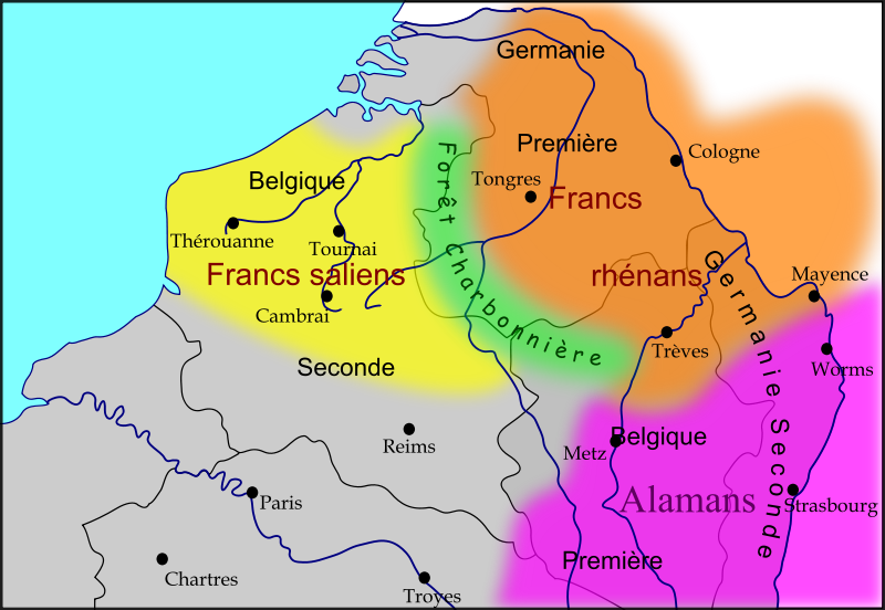
Français : Carte des royaumes Francs et Alamans dans le nord de l'ancienne Gaule romaine, dans la seconde moitié du Ve siècle Légende :
|
| Datum | |
| Bron |
Eigen werk
|
| Auteur | Odejea |
| Andere versies |
[]
|


Licentie
Ik, de auteursrechthebbende van dit werk, maak het hierbij onder de volgende licenties beschikbaar:

|
Toestemming wordt verleend voor het kopiëren, verspreiden en/of wijzigen van dit document onder de voorwaarden van de GNU-licentie voor vrije documentatie, versie 1.2 of enige latere versie als gepubliceerd door de Free Software Foundation; zonder Invariant Sections, zonder Front-Cover Texts, en zonder Back-Cover Texts. Een kopie van de licentie is opgenomen in de sectie GNU-licentie voor vrije documentatie. |
Dit bestand is gelicenseerd onder de Creative Commons-licenties Naamsvermelding-Gelijk delen 3.0 Unported, 2.5 Algemeen, 2.0 Algemeen en 1.0 Algemeen.
- De gebruiker mag:
- Delen – het werk kopiëren, verspreiden en doorgeven
- Remixen – afgeleide werken maken
- Onder de volgende voorwaarden:
- naamsvermelding – U moet op een gepaste manier aan naamsvermelding doen, een link naar de licentie geven, en aangeven of er wijzigingen in het werk zijn aangebracht. U mag dit op elke redelijke manier doen, maar niet zodanig dat de indruk wordt gewekt dat de licentiegever instemt met uw werk of uw gebruik van zijn werk.
- Gelijk delen – Als u het werk heeft geremixt, veranderd, of erop heeft voortgebouwd, moet u het gewijzigde materiaal verspreiden onder dezelfde licentie als het oorspronkelijke werk, of een daarmee compatibele licentie.
U mag zelf één van de licenties kiezen.
Bestandsgeschiedenis
Klik op een datum/tijd om het bestand te zien zoals het destijds was.
| Datum/tijd | Miniatuur | Afmetingen | Gebruiker | Opmerking | |
|---|---|---|---|---|---|
| huidige versie | 15 nov 2009 12:03 | | 1.280 × 883 (353 kB) | Odejea | Correction des frontières alamanes en fonction de cette carte |
| 15 nov 2009 11:02 |  | 1.280 × 883 (352 kB) | Odejea | correction des limites du territoire des francs rhénans | |
| 14 nov 2009 15:14 |  | 1.280 × 883 (352 kB) | Odejea | Ajout des noms des peuples barbares | |
| 14 nov 2009 00:46 |  | 1.275 × 880 (308 kB) | Odejea | {{Information |Description={{fr|1=Carte des royaumes Francs et Alamans dans le nord de l'ancienne Gaule romaine}} |Source={{own}} |Author=Odejea |Date=13 novembre 2009 |Permission= |other_versions= }} [[Category:Maps showing history of th |
Bestandsgebruik
Dit bestand wordt op de volgende 4 pagina's gebruikt:
Globaal bestandsgebruik
De volgende andere wiki's gebruiken dit bestand:
- Gebruikt op an.wikipedia.org
- Gebruikt op be.wikipedia.org
- Gebruikt op bg.wikipedia.org
- Gebruikt op ca.wikipedia.org
- Gebruikt op en.wikipedia.org
- Gebruikt op en.wiktionary.org
- Gebruikt op fr.wikipedia.org
- Gebruikt op fr.wikivoyage.org
- Gebruikt op la.wikipedia.org
- Gebruikt op lt.wikipedia.org
- Gebruikt op mk.wikipedia.org
- Gebruikt op nn.wikipedia.org
- Gebruikt op pt.wikipedia.org
- Gebruikt op ru.wikipedia.org
- Gebruikt op sl.wikipedia.org
- Gebruikt op uk.wikipedia.org
- Gebruikt op zh.wikipedia.org