
Bestand:Mahe island 76.jpg
Geen hogere resolutie beschikbaar.
Mahe_island_76.jpg (423 × 559 pixels, bestandsgrootte: 56 kB, MIME-type: image/jpeg)
| Dit is een bestand van Wikimedia Commons. Onderstaande beschrijving komt van de beschrijving van het bestand daar. |
Beschrijving
| Beschrijving |
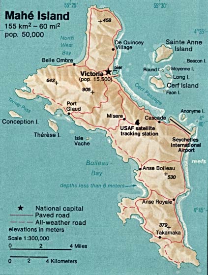
English: Topographic map of Mahé, main island of the Seychelles. |
| Datum | |
| Bron | http://www.lib.utexas.edu/maps/islands_oceans_poles/mahe_island_76.jpg |
| Auteur | CIA |
Licentie
Deze afbeelding bevindt zich in het publiek domein omdat het materiaal bevat dat oorspronkelijk afkomstig is van het CIA World Factbook.
|
 |
Bestandsgeschiedenis
Klik op een datum/tijd om het bestand te zien zoals het destijds was.
| Datum/tijd | Miniatuur | Afmetingen | Gebruiker | Opmerking | |
|---|---|---|---|---|---|
| huidige versie | 19 dec 2009 14:33 | | 423 × 559 (56 kB) | Ratzer | {{Information |Description={{en|1=topographic map of Mahé, Seychelles (main island)}} |Source=http://www.lib.utexas.edu/maps/islands_oceans_poles/mahe_island_76.jpg |Author=CIA |Date=1976 |Permission= |other_versions= }} Category:Seychelles |
Bestandsgebruik
Dit bestand wordt op de volgende pagina gebruikt:
Globaal bestandsgebruik
De volgende andere wiki's gebruiken dit bestand:
- Gebruikt op ar.wikipedia.org
- Gebruikt op az.wikipedia.org
- Gebruikt op da.wikipedia.org
- Gebruikt op de.wikipedia.org
- Gebruikt op es.wikipedia.org
- Gebruikt op fa.wikipedia.org
- Gebruikt op fi.wikipedia.org
- Gebruikt op fr.wikipedia.org
- Gebruikt op hr.wikipedia.org
- Gebruikt op hu.wikipedia.org
- Gebruikt op ie.wikipedia.org
- Gebruikt op ka.wikipedia.org
- Gebruikt op ru.wikipedia.org
- Gebruikt op sv.wikipedia.org
- Gebruikt op uk.wikipedia.org