
Bestand:Map Eschweiler.PNG
Geen hogere resolutie beschikbaar.
Map_Eschweiler.PNG (203 × 270 pixels, bestandsgrootte: 3 kB, MIME-type: image/png)
| Dit is een bestand van Wikimedia Commons. Onderstaande beschrijving komt van de beschrijving van het bestand daar. |
Beschrijving
| Beschrijving |
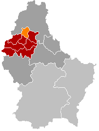
English: Map of Eschweiler municipality, valid up to 1 January 2015. Own edit of Kanton WiltzLocatie.png |
| Datum | 18 oktober 2005 (originele uploaddatum) |
| Bron | Geen machineleesbare bron opgegeven. Eigen werk aangenomen (gebaseerd op auteursrechtclaims). |
| Auteur | Geen machineleesbare auteur aanwezig. Op basis van auteursrechtclaims wordt auteur Markussep aangenomen. |
Licentie
| Ik, de auteursrechthebbende van dit werk, geef dit werk vrij in het publieke domein. Dit is wereldwijd van toepassing. In sommige landen is dit wettelijk niet mogelijk; in die gevallen geldt: Ik sta iedereen toe dit werk voor eender welk doel te gebruiken, zonder enige voorwaarden, tenzij zulke voorwaarden door de wet worden voorgeschreven. |
Bestandsgeschiedenis
Klik op een datum/tijd om het bestand te zien zoals het destijds was.
| Datum/tijd | Miniatuur | Afmetingen | Gebruiker | Opmerking | |
|---|---|---|---|---|---|
| huidige versie | 28 okt 2011 01:06 | | 203 × 270 (3 kB) | Les Meloures | change map after creation of new municipalities in Luxembourg |
| 3 mei 2006 21:45 |  | 203 × 270 (4 kB) | Markussep | ||
| 18 okt 2005 21:34 |  | 203 × 270 (4 kB) | Markussep | own edit of Image:Kanton WiltzLocatie.png Category:Maps of municipalities of Luxembourg |
Bestandsgebruik
Dit bestand wordt op de volgende pagina gebruikt:
Globaal bestandsgebruik
De volgende andere wiki's gebruiken dit bestand:
- Gebruikt op als.wikipedia.org
- Gebruikt op ca.wikipedia.org
- Gebruikt op da.wikipedia.org
- Gebruikt op en.wikipedia.org
- Gebruikt op fa.wikipedia.org
- Gebruikt op fr.wikipedia.org
- Gebruikt op it.wikipedia.org
- Gebruikt op lb.wikipedia.org
- Gebruikt op no.wikipedia.org
- Gebruikt op pt.wikipedia.org
- Gebruikt op ru.wikipedia.org
- Gebruikt op sk.wikipedia.org
- Gebruikt op tr.wikipedia.org
- Gebruikt op uk.wikipedia.org
- Gebruikt op www.wikidata.org
- Gebruikt op zh-min-nan.wikipedia.org
- Gebruikt op zh.wikipedia.org