
Bestand:Map of Churchill Harbour by Jens Munck 1624 (1897).jpg

Oorspronkelijk bestand (2.216 × 1.679 pixels, bestandsgrootte: 2,36 MB, MIME-type: image/jpeg)
| Dit is een bestand van Wikimedia Commons. Onderstaande beschrijving komt van de beschrijving van het bestand daar. |
Beschrijving
| Beschrijving |
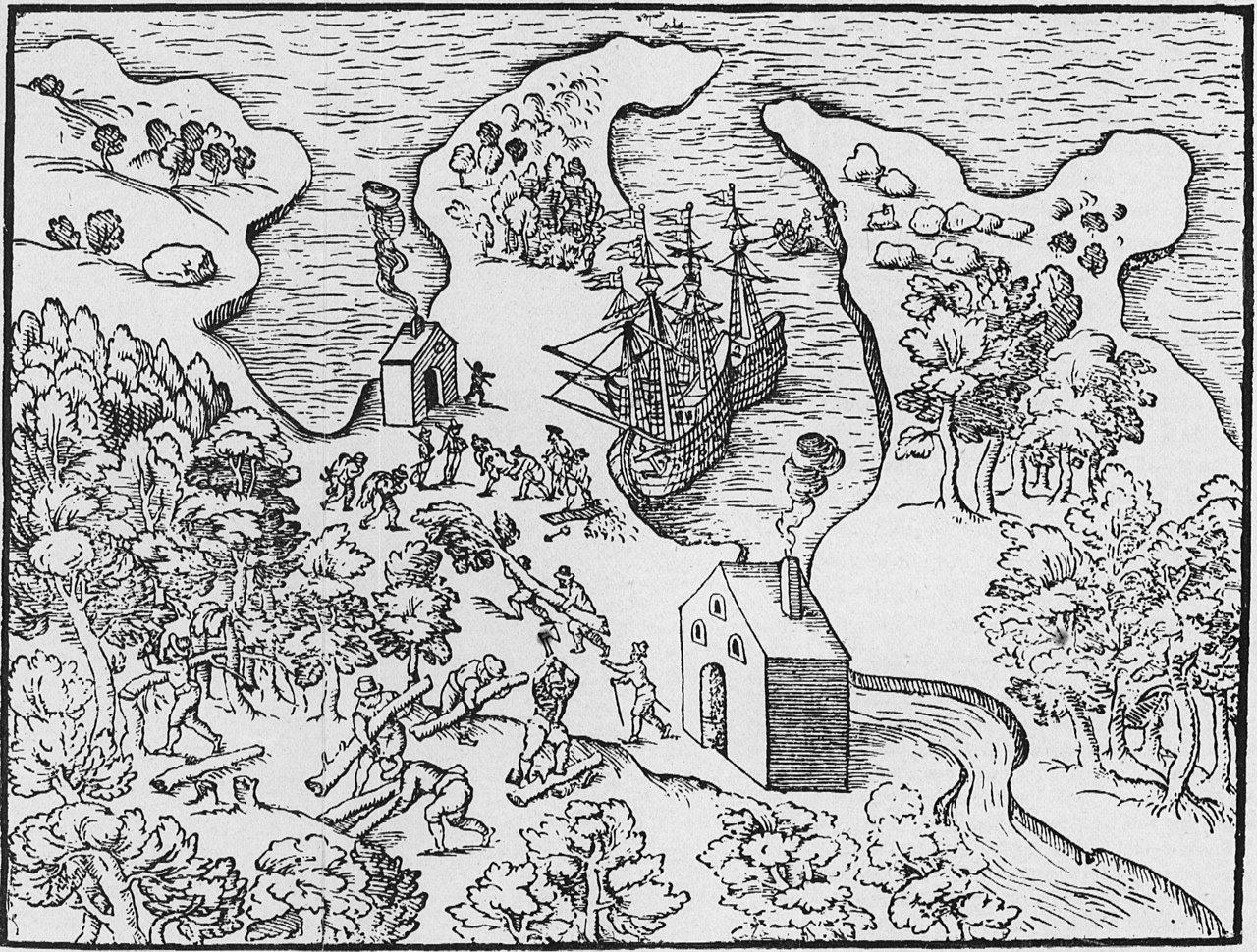
Munck, Jens. [Map of Churchill Harbour 1624] [facisimle]. [1:107,712]. In: C.C.A. Gosch. The Expedition of Captain Jens Munk to Hudson's Bay in Search of a North-West Passage in 1619-20. London: Hakluyt Society, 1897. As reproduced by, Hakluyt Society, Danish Arctic Expeditions, 1605 to 1620, Book II, vol. 97. Munck's wintering place is depicted in this interesting woodcut, which combines pictorial representation of the countryside and of activities, with a stylized map of Churchill harbour. This is the first large-scale map of a Manitoba locale. Munck's two ships are anchored off their wintering place on the west side of the harbour. Two beacons are being stoked with logs cut from the nearby forests, two sailors return from the hunt with their kill over their shoulders, and one unfortunate crew member is being prepared for burial, likely one of the victims of the scurvy. The felling of timber, a continuous necessity, is the beginning of the process which was followed by all later inhabitants, and which denuded the countryside for miles back from the site. The shape of the harbour with its encircling arms is properly, though crudely, represented and its axis is correctly oriented north to south. (Warkentin and Ruggles. Historical Atlas of Manitoba. map 4, p. 24) Original manuscript and map in University Library, Copenhagen, (MS. Additamenta, No. 184) |
||
| Datum | |||
| Bron | Map of Churchill Harbour by Jens Munck 1624 (1897) | ||
| Auteur | Manitoba Historical Maps | ||
| Andere versies |
|
_-_5_fig_3_-_Winter_Harbour_at_Churchill_River_-_1_full.png)
.jpg)
| Cameralocatie | | Deze en andere afbeeldingen in: OpenStreetMap |
|---|
.jpg¶ms=058.752531_N_-094.236602_E_globe:Earth_type:camera_source:Flickr_&language=nl)
Licentie
- De gebruiker mag:
- Delen – het werk kopiëren, verspreiden en doorgeven
- Remixen – afgeleide werken maken
- Onder de volgende voorwaarden:
- naamsvermelding – U moet op een gepaste manier aan naamsvermelding doen, een link naar de licentie geven, en aangeven of er wijzigingen in het werk zijn aangebracht. U mag dit op elke redelijke manier doen, maar niet zodanig dat de indruk wordt gewekt dat de licentiegever instemt met uw werk of uw gebruik van zijn werk.
| Deze afbeelding is oorspronkelijk op Flickr geplaatst door Manitoba Historical Maps op https://www.flickr.com/photos/11496488@N07/1128393743. Dit is op 25 juni 2011 door de FlickreviewR-Bot beoordeeld en de licentie onder de voorwaarden van cc-by-2.0 is bevestigd. |
Bestandsgeschiedenis
Klik op een datum/tijd om het bestand te zien zoals het destijds was.
| Datum/tijd | Miniatuur | Afmetingen | Gebruiker | Opmerking | |
|---|---|---|---|---|---|
| huidige versie | 25 jun 2011 17:17 | | 2.216 × 1.679 (2,36 MB) | FlickreviewR | Replacing image by its original image from Flickr |
| 25 jun 2011 16:44 |  | 500 × 379 (153 kB) | Geo Swan | {{Information |Description=Munck, Jens. [Map of Churchill Harbour 1624] [facisimle]. [1:107,712]. In: C.C.A. Gosch. The Expedition of Captain Jens Munk to Hudson's Bay in Search of a North-West Passage in 1619-20. London: Hakluyt Society, 1897. As reprodu |
Bestandsgebruik
Dit bestand wordt op de volgende pagina gebruikt:
Globaal bestandsgebruik
De volgende andere wiki's gebruiken dit bestand:
- Gebruikt op ca.wikipedia.org
- Gebruikt op fr.wikipedia.org
.jpg)