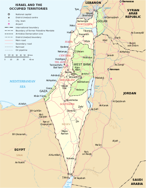
Bestand:Map of Israel, neighbours and occupied territories.svg

Afmetingen van deze voorvertoning van het type PNG van dit SVG-bestand: 465 × 600 pixels Andere resoluties: 186 × 240 pixels | 372 × 480 pixels | 595 × 768 pixels | 794 × 1.024 pixels | 1.588 × 2.048 pixels | 559 × 721 pixels.
Oorspronkelijk bestand (SVG-bestand, nominaal 559 × 721 pixels, bestandsgrootte: 650 kB)
Bestandsgeschiedenis
Klik op een datum/tijd om het bestand te zien zoals het destijds was.
| Datum/tijd | Miniatuur | Afmetingen | Gebruiker | Opmerking | |
|---|---|---|---|---|---|
| huidige versie | 7 okt 2023 18:07 |  | 559 × 721 (650 kB) | LametinoWiki | File uploaded using svgtranslate tool (https://svgtranslate.toolforge.org/). Added translation for it. |
| 7 okt 2023 18:07 |  | 559 × 721 (650 kB) | LametinoWiki | File uploaded using svgtranslate tool (https://svgtranslate.toolforge.org/). Added translation for it. | |
| 27 dec 2022 03:49 |  | 559 × 721 (596 kB) | Wikijahnn | File uploaded using svgtranslate tool (https://svgtranslate.toolforge.org/). Added translation for ca. | |
| 27 dec 2022 03:46 |  | 559 × 721 (596 kB) | Wikijahnn | File uploaded using svgtranslate tool (https://svgtranslate.toolforge.org/). Added translation for ca. | |
| 5 mei 2018 19:09 |  | 559 × 721 (540 kB) | FrankieF | Reverted to version as of 23:22, 5 March 2018 (UTC). Replaces a bad and blurred map without distance meter to a crisp and clear map. | |
| 10 mrt 2018 20:47 |  | 559 × 721 (285 kB) | Eric's son | The last version is outdated and factually incorrect. Reverted to version as of 21:50, 26 February 2018 (UTC) | |
| 6 mrt 2018 01:22 |  | 559 × 721 (540 kB) | Nableezy | Reverted to version as of 16:20, 12 December 2011 (UTC) make a different map, dont replace every other with this one | |
| 26 feb 2018 23:50 |  | 559 × 721 (285 kB) | Eric's son | small graphic fixes | |
| 20 feb 2018 00:24 |  | 559 × 721 (259 kB) | Eric's son | Adding relevant updates (evacuated UN zones), clear colored borders explained in legend. | |
| 12 dec 2011 18:20 |  | 559 × 721 (540 kB) | Ch1902 | =={{int:filedesc}}== {{Information |Description={{en|1=Map of the Middle East showing Israel, Egypt, Saudi Arabia, Jordan, Syria and Lebanon including Gaza, Golan Heights and West Bank.}} |Source=SVG extracted and edited from [http://www.un.org/Depts/Car |
Bestandsgebruik
Dit bestand wordt op de volgende pagina gebruikt:
Globaal bestandsgebruik
De volgende andere wiki's gebruiken dit bestand:
- Gebruikt op ary.wikipedia.org
- Gebruikt op azb.wikipedia.org
- Gebruikt op bxr.wikipedia.org
- Gebruikt op ca.wikipedia.org
- Gebruikt op da.wikipedia.org
- Gebruikt op en.wikipedia.org
- Gebruikt op ga.wikipedia.org
- Gebruikt op gl.wikipedia.org
- Gebruikt op hy.wikipedia.org
- Gebruikt op it.wikipedia.org
- Gebruikt op kn.wikipedia.org
- Gebruikt op ko.wikipedia.org
- Gebruikt op pap.wikipedia.org
- Gebruikt op pnb.wikipedia.org
- Gebruikt op ru.wikipedia.org
- Gebruikt op sr.wikipedia.org
- Gebruikt op sv.wikipedia.org
- Gebruikt op www.wikidata.org

