
Bestand:Map of South Africa with provinces shaded and districts numbered (2011).svg

Afmetingen van deze voorvertoning van het type PNG van dit SVG-bestand: 684 × 599 pixels Andere resoluties: 274 × 240 pixels | 548 × 480 pixels | 876 × 768 pixels | 1.168 × 1.024 pixels | 2.337 × 2.048 pixels | 809 × 709 pixels.
Oorspronkelijk bestand (SVG-bestand, nominaal 809 × 709 pixels, bestandsgrootte: 845 kB)
| Dit is een bestand van Wikimedia Commons. Onderstaande beschrijving komt van de beschrijving van het bestand daar. |
.svg)
W3C-validity not checked.
Beschrijving
| Beschrijving |
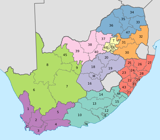
English: Map of South Africa with provincial and district boundaries. The provinces are shaded as follows:
Eastern Cape
Free State
Gauteng
KwaZulu-Natal
Limpopo
Mpumalanga
North West
Northern Cape
Western Cape
The district municipalities are labelled with their code, excluding the letters "DC"; for example, Xhariep District Municipality, which has code DC16, is labelled with a 16. The metropolitan municipalities are labelled with letters. B: Buffalo City; C: City of Cape Town; Ek: Ekurhuleni; Et: eThekwini; J: City of Johannesburg; M: Mangaung; N: Nelson Mandela Bay; T: City of Tshwane. |
| Datum | |
| Bron | Eigen werk |
| Auteur | Htonl |
| Andere versies | File:Map of South Africa with district borders (2011).svg |
.svg)
Licentie
Ik, de auteursrechthebbende van dit werk, maak het hierbij onder de volgende licenties beschikbaar:
Dit bestand is gelicenseerd onder de Creative Commons-licentie Naamsvermelding-Gelijk delen 3.0 Unported
- De gebruiker mag:
- Delen – het werk kopiëren, verspreiden en doorgeven
- Remixen – afgeleide werken maken
- Onder de volgende voorwaarden:
- naamsvermelding – U moet op een gepaste manier aan naamsvermelding doen, een link naar de licentie geven, en aangeven of er wijzigingen in het werk zijn aangebracht. U mag dit op elke redelijke manier doen, maar niet zodanig dat de indruk wordt gewekt dat de licentiegever instemt met uw werk of uw gebruik van zijn werk.
- Gelijk delen – Als u het werk heeft geremixt, veranderd, of erop heeft voortgebouwd, moet u het gewijzigde materiaal verspreiden onder dezelfde licentie als het oorspronkelijke werk, of een daarmee compatibele licentie.

|
Toestemming wordt verleend voor het kopiëren, verspreiden en/of wijzigen van dit document onder de voorwaarden van de GNU-licentie voor vrije documentatie, versie 1.2 of enige latere versie als gepubliceerd door de Free Software Foundation; zonder Invariant Sections, zonder Front-Cover Texts, en zonder Back-Cover Texts. Een kopie van de licentie is opgenomen in de sectie GNU-licentie voor vrije documentatie. |
U mag zelf één van de licenties kiezen.
Bestandsgeschiedenis
Klik op een datum/tijd om het bestand te zien zoals het destijds was.
| Datum/tijd | Miniatuur | Afmetingen | Gebruiker | Opmerking | |
|---|---|---|---|---|---|
| huidige versie | 2 mei 2011 13:48 | | 809 × 709 (845 kB) | Htonl | fix numbers |
| 2 mei 2011 04:57 |  | 809 × 709 (844 kB) | Htonl | swap FS and GT colours | |
| 16 apr 2011 19:49 |  | 809 × 709 (844 kB) | Htonl | {{Information |Description ={{en|1=Map of South Africa with provincial and district boundaries. The provinces are shaded as follows: {{legend|#8DD3C7|Eastern Cape}} {{legend|#FFFFB3|Free State}} {{legend|#BEBADA|Gauteng}} {{legend|#FB8072|KwaZulu-Natal |
Bestandsgebruik
Dit bestand wordt op de volgende pagina gebruikt:
Globaal bestandsgebruik
De volgende andere wiki's gebruiken dit bestand:
- Gebruikt op af.wikipedia.org
- Gebruikt op de.wikipedia.org
- Gebruikt op en.wikipedia.org
- Gebruikt op es.wikipedia.org
- Gebruikt op fr.wikipedia.org
- Gebruikt op hi.wikipedia.org
- Gebruikt op id.wikipedia.org
- Gebruikt op ja.wikipedia.org
- Gebruikt op tn.wikipedia.org
.svg)