
Bestand:Map of the Ancient Rome at Caesar time (with conquests)-fr.svg

Afmetingen van deze voorvertoning van het type PNG van dit SVG-bestand: 800 × 473 pixels Andere resoluties: 320 × 189 pixels | 640 × 379 pixels | 1.024 × 606 pixels | 1.280 × 757 pixels | 2.560 × 1.515 pixels | 2.050 × 1.213 pixels.
Oorspronkelijk bestand (SVG-bestand, nominaal 2.050 × 1.213 pixels, bestandsgrootte: 1,26 MB)
| Dit is een bestand van Wikimedia Commons. Onderstaande beschrijving komt van de beschrijving van het bestand daar. |
| Beschrijving |
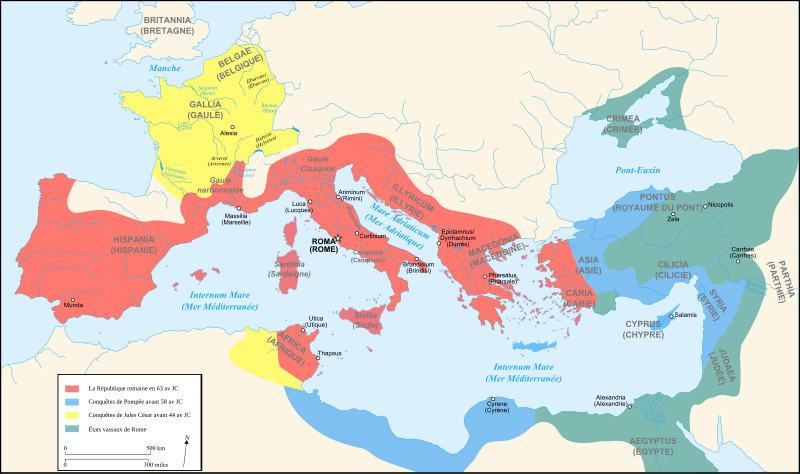
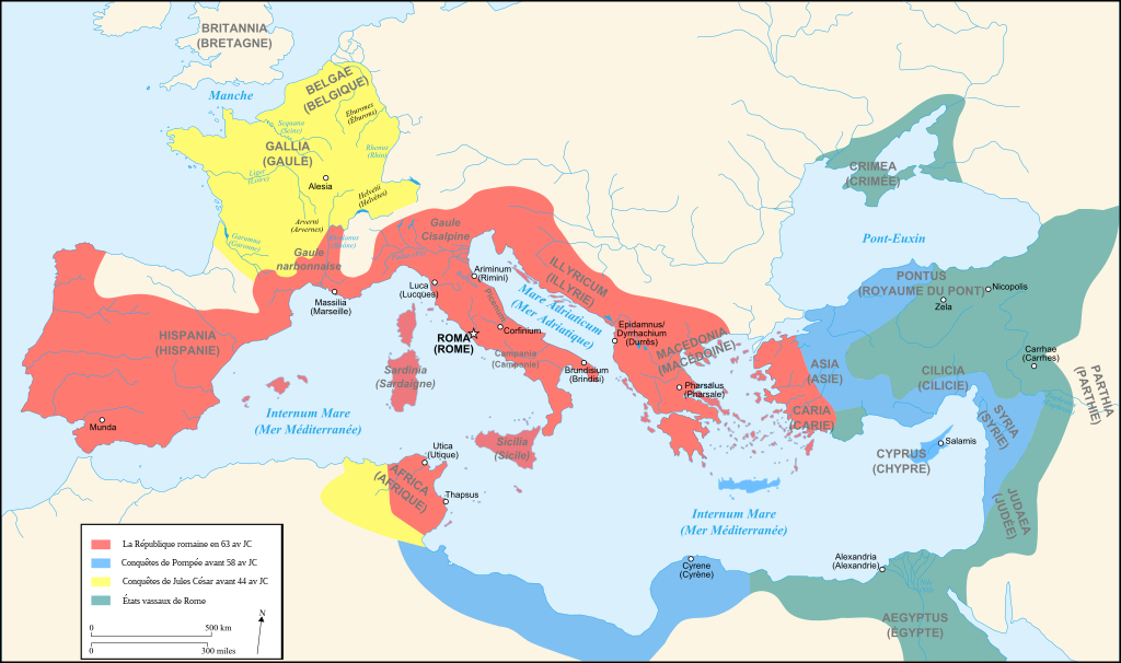
Français : Carte de l'Empire Romain au Ier siècle av JC English: Map of Roman Empire (1st century BC) . |
||||||||
| Datum | |||||||||
| Bron | Own work + Image:Blank map of South Europe and North Africa.svg by myself | ||||||||
| Auteur | User:Historicair um15:17, 13 August 2007 (UTC) | ||||||||
| Toestemming (Hergebruik van dit bestand) |
Ik, de auteursrechthebbende van dit werk, maak het hierbij onder de volgende licenties beschikbaar:
Dit bestand is gelicenseerd onder de Creative Commons-licenties Naamsvermelding-Gelijk delen 2.5 Algemeen, 2.0 Algemeen en 1.0 Algemeen.
U mag zelf één van de licenties kiezen. |
||||||||
| Andere versies |
[]
|

-en.svg)
-es.svg)
-fr.svg)
-zh.svg)
-fr.svg)
-fr.svg)
|
Dit SVG-bestand maakt gebruik van geïntegreerde tekst die gemakkelijk kan worden vertaald naar uw taal met een SVG editor, een tekstverwerker of het hulpmiddel SVG Translate. Uitleg |
-fr.svg)
[[Category:yo snot dog go in Apia house
]]
Bestandsgeschiedenis
Klik op een datum/tijd om het bestand te zien zoals het destijds was.
| Datum/tijd | Miniatuur | Afmetingen | Gebruiker | Opmerking | |
|---|---|---|---|---|---|
| huidige versie | 13 aug 2007 17:17 | | 2.050 × 1.213 (1,26 MB) | Historicair | {{Information |Description={{fr}}Carte de l'Empire Romain au Ier siècle av JC {{en}}Map of Roman Empire (1st century BC). |Source=Own work + Image:Blank map of South Europe and North Africa.svg by myself |Date=13/08/2007 |Author=~~~~ |Permission={{s |
Bestandsgebruik
Dit bestand wordt op de volgende pagina gebruikt:
Globaal bestandsgebruik
De volgende andere wiki's gebruiken dit bestand:
- Gebruikt op en.wikipedia.org
- Gebruikt op eu.wikipedia.org
- Gebruikt op fa.wikipedia.org
- Gebruikt op fr.wikipedia.org
- Gebruikt op fur.wikipedia.org
- Gebruikt op th.wikipedia.org
-fr.svg)