
Bestand:Map of the Territory of the Iceni.svg

Afmetingen van deze voorvertoning van het type PNG van dit SVG-bestand: 424 × 600 pixels Andere resoluties: 170 × 240 pixels | 339 × 480 pixels | 543 × 768 pixels | 724 × 1.024 pixels | 1.448 × 2.048 pixels | 744 × 1.052 pixels.
Oorspronkelijk bestand (SVG-bestand, nominaal 744 × 1.052 pixels, bestandsgrootte: 151 kB)
| Dit is een bestand van Wikimedia Commons. Onderstaande beschrijving komt van de beschrijving van het bestand daar. |
| Beschrijving |
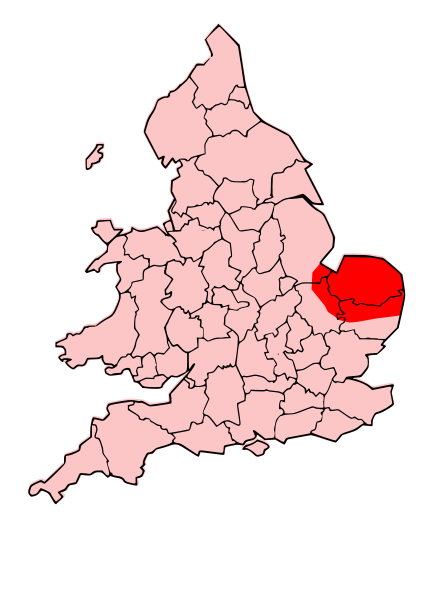
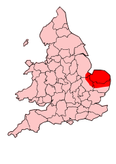
English: A map showing the territory of the Iceni tribe overlayed in red in the context of the modern county boundaries of England and wales |
| Datum | (UTC) |
| Bron | |
| Auteur |
|
.svg)
.png)
| Dit is een geretoucheerde foto, wat betekent dat de originele versie digitaal aangepast is. Aanpassingen: Revised to show extent of Iceni Territory. Het origineel kan hier bekeken worden: Map of the Territory of the Dobunni.svg. Aanpassingen gedaan door Jpb1301.
|
Dit bestand is gelicenseerd onder de Creative Commons-licentie Naamsvermelding-Gelijk delen 3.0 Unported
- De gebruiker mag:
- Delen – het werk kopiëren, verspreiden en doorgeven
- Remixen – afgeleide werken maken
- Onder de volgende voorwaarden:
- naamsvermelding – U moet op een gepaste manier aan naamsvermelding doen, een link naar de licentie geven, en aangeven of er wijzigingen in het werk zijn aangebracht. U mag dit op elke redelijke manier doen, maar niet zodanig dat de indruk wordt gewekt dat de licentiegever instemt met uw werk of uw gebruik van zijn werk.
- Gelijk delen – Als u het werk heeft geremixt, veranderd, of erop heeft voortgebouwd, moet u het gewijzigde materiaal verspreiden onder dezelfde licentie als het oorspronkelijke werk, of een daarmee compatibele licentie.
Oorspronkelijk uploadlogboek
This image is a derivative work of the following images:
- File:England_Celtic_tribes_-_South.png licensed with Cc-by-sa-3.0-migrated, GFDL
- 2007-11-16T12:21:48Z File Upload Bot (Magnus Manske) 550x297 (105767 Bytes) {{BotMoveToCommons|en.wikipedia}} {{Information |Description={{en|Image depicting the Celts of South England, pre-[[:en:Roman Britain]] times. I created this myself, under the guidence (to find location of them) of [http://w
- File:Map_of_the_Territory_of_the_Dobunni.svg licensed with Cc-by-sa-3.0, GFDL
- 2009-10-13T19:47:34Z Jpb1301 744x1052 (151192 Bytes) {{Information |Description={{en|1=A map showing the territory of the Dobunni tribe overlayed in red in the context of the modern county boundaries of England and wales}} |Source=*[[:File:Map_of_the_Territory_of_the_Dobunni.sv
- 2009-10-13T17:38:36Z Jpb1301 744x1052 (151194 Bytes) {{Information |Description={{en|1=A map showing the territory of the Dobunni tribe overlayed in red in the context of the modern county boundaries of England and wales}} |Source=*[[:File:Map_of_the_Territory_of_the_Cornovii_(
Uploaded with derivativeFX
Bestandsgeschiedenis
Klik op een datum/tijd om het bestand te zien zoals het destijds was.
| Datum/tijd | Miniatuur | Afmetingen | Gebruiker | Opmerking | |
|---|---|---|---|---|---|
| huidige versie | 24 okt 2009 21:30 | | 744 × 1.052 (151 kB) | Jpb1301 | {{Information |Description={{en|1=A map showing the territory of the Iceni tribe overlayed in red in the context of the modern county boundaries of England and wales}} |Source=*File:England_Celtic_tribes_-_South.png *[[:File:Map_of_the_Territory_of_ |
Bestandsgebruik
Dit bestand wordt op de volgende pagina gebruikt:
Globaal bestandsgebruik
De volgende andere wiki's gebruiken dit bestand:
- Gebruikt op ar.wikipedia.org
- Gebruikt op bg.wikipedia.org
- Gebruikt op br.wikipedia.org
- Gebruikt op ca.wikipedia.org
- Gebruikt op da.wikipedia.org
- Gebruikt op en.wikipedia.org
- Gebruikt op es.wikipedia.org
- Gebruikt op fa.wikipedia.org
- Gebruikt op fi.wikipedia.org
- Gebruikt op he.wikipedia.org
- Gebruikt op hr.wikipedia.org
- Gebruikt op hy.wikipedia.org
- Gebruikt op id.wikipedia.org
- Gebruikt op it.wikipedia.org
- Gebruikt op ja.wikipedia.org
- Gebruikt op la.wikipedia.org
- Gebruikt op no.wikipedia.org
- Gebruikt op pl.wikipedia.org
- Gebruikt op pt.wikipedia.org
- Gebruikt op ro.wikipedia.org
- Gebruikt op ru.wikipedia.org
- Gebruikt op si.wikipedia.org
- Gebruikt op sv.wikipedia.org
- Gebruikt op uk.wikipedia.org
- Gebruikt op ur.wikipedia.org