
Bestand:Map of the flooding areas of the Lake Nasser in the Wadi Halfa Salient.png

Grootte van deze voorvertoning: 571 × 600 pixels. Andere resoluties: 228 × 240 pixels | 457 × 480 pixels | 909 × 955 pixels.
Oorspronkelijk bestand (909 × 955 pixels, bestandsgrootte: 1,25 MB, MIME-type: image/png)
| Dit is een bestand van Wikimedia Commons. Onderstaande beschrijving komt van de beschrijving van het bestand daar. |
| Beschrijving |
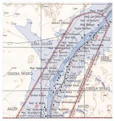
Deutsch: Überflutungsgebiet des Nasser-Stausees im Wadi Halfa Salient
English: Flooding areas of the Lake Nasser in the Wadi Halfa Salient |
||||||
| Datum | see file history | ||||||
| Bron |
own work, using the following files:
|
||||||
| Auteur | Maximilian Dörrbecker (Chumwa) | ||||||
| Toestemming (Hergebruik van dit bestand) |
Ik, de auteursrechthebbende van dit werk, maak het hierbij onder de volgende licentie beschikbaar: Dit bestand is gelicenseerd onder de Creative Commons-licentie Naamsvermelding-Gelijk delen 2.5 Unported
|
||||||
| Andere versies |
|


Bestandsgeschiedenis
Klik op een datum/tijd om het bestand te zien zoals het destijds was.
| Datum/tijd | Miniatuur | Afmetingen | Gebruiker | Opmerking | |
|---|---|---|---|---|---|
| huidige versie | 20 jun 2009 08:25 | | 909 × 955 (1,25 MB) | Chumwa | {{Information |Description={{de|Überflutungsgebiet des Nasser-Stausees im Wadi Halfa Salient}} {{en|Flooding areas of the Lake Nasser in the Wadi Halfa Salient}} |Source=own work, using the following files: * [[:File:Wadi Halfa Salient-txu-oclc-6949452- |
Bestandsgebruik
Dit bestand wordt op de volgende pagina gebruikt:
Globaal bestandsgebruik
De volgende andere wiki's gebruiken dit bestand:
- Gebruikt op ar.wikipedia.org
- Gebruikt op bg.wikipedia.org
- Gebruikt op ca.wikipedia.org
- Gebruikt op de.wikipedia.org
- Gebruikt op el.wikipedia.org
- Gebruikt op en.wikipedia.org
- Gebruikt op fr.wikipedia.org
- Gebruikt op id.wikipedia.org
- Gebruikt op it.wikipedia.org
- Gebruikt op ja.wikipedia.org