
Bestand:Map of the tunnels of the Faroe Islands.png

Grootte van deze voorvertoning: 568 × 600 pixels. Andere resoluties: 227 × 240 pixels | 455 × 480 pixels | 728 × 768 pixels | 970 × 1.024 pixels | 1.940 × 2.048 pixels | 3.027 × 3.195 pixels.
Oorspronkelijk bestand (3.027 × 3.195 pixels, bestandsgrootte: 3,21 MB, MIME-type: image/png)
| Dit is een bestand van Wikimedia Commons. Onderstaande beschrijving komt van de beschrijving van het bestand daar. |

|
Deze kaartafbeelding zou opnieuw moeten worden aangemaakt als een SVG-bestand door vectorafbeeldingen te gebruiken. Dit heeft een aantal voordelen; zie Commons:Media for cleanup voor meer informatie. Als er een SVG-formaat van deze afbeelding bestaat, dan deze graag uploaden. Nadat u dit heeft gedaan, gelieve dit sjabloon te vervangen door het sjabloon {{vector version available|nieuwe bestandsnaam.svg}} op deze afbeeldingspagina.
|
| Beschrijving |
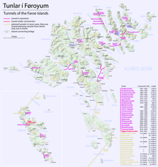
Català: Mapa dels túnels de les Illes Fèroe
Deutsch: Karte der Tunnel auf den Färöern
English: Map of the tunnels of the Faroe Islands |
| Datum | see file history |
| Bron | Eigen werk, using Openstreetmap data for the background |
| Auteur | Maximilian Dörrbecker (Chumwa) |
| Toestemming (Hergebruik van dit bestand) |
All OpenStreetMap data and maps are Creative Commons "CC-BY-SA 2.0" licensed Dit bestand is gelicenseerd onder de Creative Commons-licentie Naamsvermelding-Gelijk delen 2.0 Unported
|
Bestandsgeschiedenis
Klik op een datum/tijd om het bestand te zien zoals het destijds was.
| Datum/tijd | Miniatuur | Afmetingen | Gebruiker | Opmerking | |
|---|---|---|---|---|---|
| huidige versie | 19 dec 2020 20:19 | | 3.027 × 3.195 (3,21 MB) | Karl432 | Eysturoyatunnilin opened on 2020-12-19 |
| 23 dec 2016 09:51 |  | 3.027 × 3.195 (3,21 MB) | Chumwa | ||
| 21 dec 2016 18:31 |  | 3.027 × 3.195 (3,02 MB) | Chumwa | ||
| 21 dec 2016 01:09 |  | 3.011 × 3.195 (946 kB) | Chumwa | ||
| 21 dec 2016 00:34 |  | 3.011 × 3.195 (942 kB) | Chumwa | ||
| 19 dec 2016 23:15 |  | 3.011 × 3.195 (929 kB) | Chumwa | ||
| 19 dec 2016 08:36 |  | 3.011 × 3.195 (904 kB) | Chumwa | ||
| 19 dec 2016 01:05 |  | 3.011 × 3.195 (886 kB) | Chumwa | ||
| 18 dec 2016 20:53 |  | 3.011 × 3.195 (902 kB) | Chumwa | {{Information |Description= {{de|Karte der Tunnel auf den Färöern}} {{en|Map of the tunnels of the Faroe Islands}} |Author=Maximilian Dörrbecker (Chumwa) |Source={{own}}, using Openstreetmap data for the back... |
Bestandsgebruik
Dit bestand wordt op de volgende pagina gebruikt:
Globaal bestandsgebruik
De volgende andere wiki's gebruiken dit bestand:
- Gebruikt op ca.wikipedia.org
- Gebruikt op cs.wikipedia.org
- Gebruikt op da.wikipedia.org
- Gebruikt op de.wikipedia.org
- Gebruikt op en.wikipedia.org
- Gebruikt op en.wikivoyage.org
- Gebruikt op fo.wikipedia.org
- Gebruikt op fr.wikipedia.org
- Gebruikt op hu.wikipedia.org
- Gebruikt op is.wikipedia.org
- Gebruikt op it.wikipedia.org
- Gebruikt op no.wikipedia.org
- Gebruikt op sv.wikipedia.org