
Bestand:Mar Balear delineada.jpg

Grootte van deze voorvertoning: 643 × 600 pixels. Andere resoluties: 257 × 240 pixels | 514 × 480 pixels | 823 × 768 pixels | 1.060 × 989 pixels.
Oorspronkelijk bestand (1.060 × 989 pixels, bestandsgrootte: 203 kB, MIME-type: image/jpeg)
| Dit is een bestand van Wikimedia Commons. Onderstaande beschrijving komt van de beschrijving van het bestand daar. |
Beschrijving
| Beschrijving |
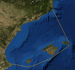
Català: Foto satèl·lit de la Mar Balear, delineada
Español: Foto satelital del Mar Balear
English: Satellite Picture of the Balearic Sea, delineated |
|||
| Datum | ||||
| Bron | Satellite picture from NASA World Wind Globe, version 1.4; lines my work, based on definition at Limits of Oceans and Seas, 3rd edition by International Hydrographic Organisation. | |||
| Auteur | NASA, Rwxrwxrwx | |||
| Toestemming (Hergebruik van dit bestand) |
|

Bestandsgeschiedenis
Klik op een datum/tijd om het bestand te zien zoals het destijds was.
| Datum/tijd | Miniatuur | Afmetingen | Gebruiker | Opmerking | |
|---|---|---|---|---|---|
| huidige versie | 30 sep 2014 22:50 | | 1.060 × 989 (203 kB) | Rwxrwxrwx | User created page with UploadWizard |
Bestandsgebruik
Dit bestand wordt op de volgende pagina gebruikt:
Globaal bestandsgebruik
De volgende andere wiki's gebruiken dit bestand:
- Gebruikt op bn.wikipedia.org
- Gebruikt op bs.wikipedia.org
- Gebruikt op ca.wikipedia.org
- Gebruikt op co.wikipedia.org
- Gebruikt op da.wikipedia.org
- Gebruikt op de.wikipedia.org
- Gebruikt op en.wikipedia.org
- Gebruikt op es.wikipedia.org
- Gebruikt op eu.wikipedia.org
- Gebruikt op fr.wikipedia.org
- Gebruikt op gl.wikipedia.org
- Gebruikt op he.wikipedia.org
- Gebruikt op hr.wikipedia.org
- Gebruikt op ilo.wikipedia.org
- Gebruikt op it.wikipedia.org
- Gebruikt op ja.wikipedia.org
- Gebruikt op pl.wiktionary.org
- Gebruikt op uk.wikipedia.org