
Bestand:MtRuapehu 23oct2002.jpg

Grootte van deze voorvertoning: 800 × 600 pixels. Andere resoluties: 320 × 240 pixels | 640 × 480 pixels | 1.024 × 768 pixels | 1.280 × 960 pixels | 2.560 × 1.920 pixels | 4.500 × 3.375 pixels.
Oorspronkelijk bestand (4.500 × 3.375 pixels, bestandsgrootte: 3,2 MB, MIME-type: image/jpeg)
| Dit is een bestand van Wikimedia Commons. Onderstaande beschrijving komt van de beschrijving van het bestand daar. |
Beschrijving
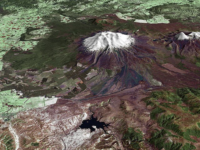
| Beschrijving | Composite image of Mount Ruapehu, with Hauhungatahi visible beyond. North Island, New Zealand. Image is composed of satellite imagery from Landsat and topography data from the Shuttle Radar Topography Mission aboard the Space Shuttle Endeavour. |
| Datum | |
| Bron | http://earthobservatory.nasa.gov/Newsroom/NewImages/images.php3?img_id=16522 |
| Auteur |
Landsat data provided courtesy of the University of Maryland Global Land Cover Facility Landsat processing by Laura Rocchio, Landsat Project Science Office SRTM 3-arcsecond elevation data courtesy of SRTM Team NASA/JPL/NIMA Visualization created by Earth Observatory staff. |
| Toestemming (Hergebruik van dit bestand) |
Public domain |
Licentie
| Dit bestand bevindt zich in het publiek domein, omdat het gemaakt is door de NASA. In de reproductierichtlijnen van de NASA staat dat "NASA-materiaal niet beschermd wordt door auteursrecht, tenzij anders vermeld". | ||
 |
Waarschuwingen:
|
Bestandsgeschiedenis
Klik op een datum/tijd om het bestand te zien zoals het destijds was.
| Datum/tijd | Miniatuur | Afmetingen | Gebruiker | Opmerking | |
|---|---|---|---|---|---|
| huidige versie | 28 apr 2010 17:17 | | 4.500 × 3.375 (3,2 MB) | Originalwana | higher res |
| 25 mei 2006 22:56 |  | 1.800 × 1.800 (819 kB) | Holly Cheng | {{Information | Description=Composite image of w:Mount Ruapehu, North Island, New Zealand. Image is composed of satellite imagery from Landsat and topography data from the Shuttle Radar Topography Mission aboard the Space Shuttle Endeavour. | Source=h |
Bestandsgebruik
Dit bestand wordt op de volgende pagina gebruikt:
Globaal bestandsgebruik
De volgende andere wiki's gebruiken dit bestand:
- Gebruikt op ar.wikipedia.org
- Gebruikt op ceb.wikipedia.org
- Gebruikt op de.wikipedia.org
- Gebruikt op en.wikipedia.org
- Gebruikt op en.wikiversity.org
- Gebruikt op gl.wikipedia.org
- Gebruikt op hr.wikipedia.org
- Gebruikt op hy.wikipedia.org
- Gebruikt op it.wikipedia.org
- Gebruikt op ja.wikipedia.org
- Gebruikt op ko.wikipedia.org
- Gebruikt op mk.wikipedia.org
- Gebruikt op nn.wikipedia.org
- Gebruikt op pl.wikipedia.org
- Gebruikt op sh.wikipedia.org
- Gebruikt op sl.wikipedia.org
- Gebruikt op sv.wikipedia.org
- Gebruikt op zh.wikipedia.org