
Bestand:North America.png
Grootte van deze voorvertoning: 466 × 599 pixels. Andere resoluties: 187 × 240 pixels | 373 × 480 pixels | 673 × 865 pixels.
Oorspronkelijk bestand (673 × 865 pixels, bestandsgrootte: 709 kB, MIME-type: image/png)
| Dit is een bestand van Wikimedia Commons. Onderstaande beschrijving komt van de beschrijving van het bestand daar. |
Beschrijving
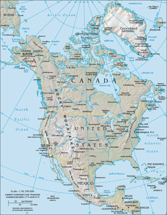
| Beschrijving | Physical and Political map of North America |
| Bron | The CIA FactBook at https://www.cia.gov/library/publications/resources/the-world-factbook/docs/refmaps.html |
| Auteur | US Federal Government |
| Toestemming (Hergebruik van dit bestand) |
Public Domain |
| Andere versies |
[]
|


Licentie
Deze afbeelding bevindt zich in het publiek domein omdat het materiaal bevat dat oorspronkelijk afkomstig is van het CIA World Factbook.
|
 |
Bestandsgeschiedenis
Klik op een datum/tijd om het bestand te zien zoals het destijds was.
| Datum/tijd | Miniatuur | Afmetingen | Gebruiker | Opmerking | |
|---|---|---|---|---|---|
| huidige versie | 25 jun 2011 08:19 | | 673 × 865 (709 kB) | AlexCovarrubias | Cropping map to avoid title bar |
| 16 sep 2006 08:22 |  | 675 × 894 (686 kB) | Shushruth | {{Information |Description=Physical and Political map of North America |Source=The CIA FactBook at https://www.cia.gov/cia/publications/factbook/reference_maps/north_america.html |Author= US Federal Government |Permission= Public Domain }} |
Bestandsgebruik
Dit bestand wordt op de volgende pagina gebruikt:
Globaal bestandsgebruik
De volgende andere wiki's gebruiken dit bestand:
- Gebruikt op af.wikipedia.org
- Gebruikt op ca.wikipedia.org
- Gebruikt op cy.wikipedia.org
- Gebruikt op de.wikipedia.org
- Gebruikt op en.wikipedia.org
- History of North America
- North American Cordillera
- User:Jre
- User:Louis Waweru
- User:Jcmenal
- User:Billgdiaz
- User:Jcmenal/North American
- User:Seanwarner86
- User:Vreddy92
- User:Tang Wenlong
- User:Backvoods
- User:Djdavi
- User:Kev098
- User:Mokoniki
- User:Rocco avila
- User:Stiddy
- User:Yongbyong38
- User:Trfaes/North American
- User:Trfaes
- User:Brout8
- Gebruikt op eo.wikipedia.org
- Gebruikt op es.wikipedia.org
- Gebruikt op es.wikibooks.org
- Gebruikt op eu.wikipedia.org
- Gebruikt op fa.wikipedia.org
- Gebruikt op fi.wikipedia.org
- Gebruikt op id.wikipedia.org
- Gebruikt op ilo.wikipedia.org
- Gebruikt op incubator.wikimedia.org
Globaal gebruik van dit bestand bekijken.