
Bestand:North America (orthographic projection).svg

Afmetingen van deze voorvertoning van het type PNG van dit SVG-bestand: 550 × 550 pixels Andere resoluties: 240 × 240 pixels | 480 × 480 pixels | 768 × 768 pixels | 1.024 × 1.024 pixels | 2.048 × 2.048 pixels.
Oorspronkelijk bestand (SVG-bestand, nominaal 550 × 550 pixels, bestandsgrootte: 457 kB)
| Dit is een bestand van Wikimedia Commons. Onderstaande beschrijving komt van de beschrijving van het bestand daar. |
Beschrijving
| Beschrijving |
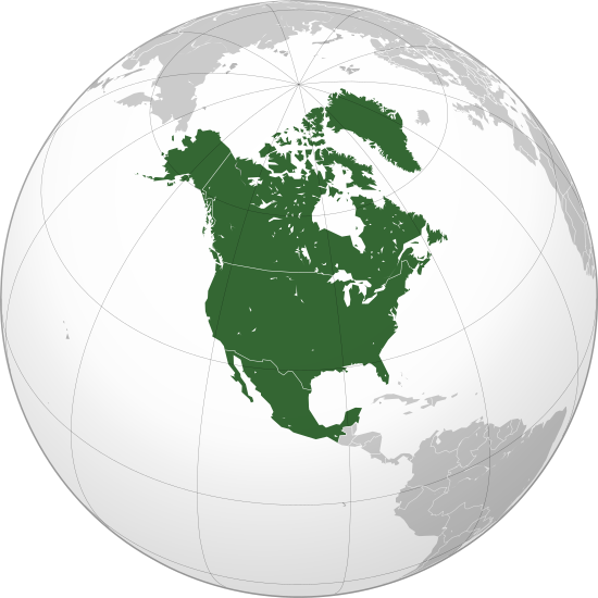
বাংলা: ওত্তরী আমেরিকার অর্থোগ্রাফিক মানচিত্র हिन्दी: उत्तरी अमेरिका का लेखनप्रक्षेपीय मानचित्र English: North America (orthographic projection) |
||||
| Datum | |||||
| Bron |
Eigen werk (Originele tekst: Own work,)
|
||||
| Auteur | Heraldry | ||||
| Toestemming (Hergebruik van dit bestand) |
|
||||
| Andere versies |
Afgeleide werken van dit bestand: BK North America (orthographic projection).png .svg) |
||||
| SVG ontwikkeling | SVG watermarked with invisible embedded text. |

.svg)
.svg)
.svg)
.svg)
.svg)
.svg)
.svg)
.svg)
.svg)
.svg)
.svg)
.svg)
.svg)
.svg)
.svg)
.svg)
.svg)
.svg)
.svg)
.svg)
.svg)
.svg)
.svg)
.svg)
.svg)
.svg)
.svg)
.svg)
.svg)
.svg)
.svg)
.svg)
.svg)
.svg)
.svg)
.svg)
.svg)
.svg)
.svg)
.svg)
.svg)
.svg)
.svg)
.svg)
.svg)
.svg)
.svg)
.svg)
.svg)
.svg)
.svg)
.svg)
.svg)
.svg)
.svg)
.svg)
.svg)
.svg)
.svg)
.svg)
.svg)
.svg)
.svg)
.svg)
.svg)
.svg)
.svg)
.svg)
.svg)
.svg)
.svg)
.svg)
.svg)

.svg)

.svg)

.svg)
.svg)
.svg)
.svg)
.svg)
.svg)
.svg)


.svg)
.svg)
.svg)
.svg)
.svg)
.svg)
.svg)

.svg)
.svg)
.svg)
.svg)
.svg)
.svg)
.svg)
.svg)
.svg)
.svg)

.svg)
.svg)
.svg)
.svg)
.svg)
.svg)
.svg)
_without_national_boundaries.svg)
.svg)
.svg)
.svg)
.svg)
.svg)
.svg)

.svg)
.svg)
.png)
.svg)
.svg)
.svg)
.svg)

.svg)
.svg)
.svg)
.svg)
.svg)
.svg)
.svg)
.svg)
.svg)
.svg)
.svg)

.svg)
.svg)
.svg)
.svg)
.svg)
.svg)
.svg)
.svg)
.svg)

.svg)
.svg)

.svg)
.svg)
.svg)
.svg)
.svg)
.svg)
.svg)
.svg)
.svg)
.svg)
.svg)
.svg)
.svg)
.svg)
.svg)
.svg)
.svg)
.svg)
.svg)
.svg)
.svg)
.svg)
.svg)
.svg)
.svg)
.svg)
.svg)
_-_Crimea_disputed.svg)
.svg)
.svg)
.svg)
.svg)
.svg)
.svg)
.svg)
.svg)
.svg)
.svg)
.svg)
_political.svg)
.svg)
.svg)
.svg)
.svg)
_-_Crimea_disputed_-_no_borders.svg)
.svg)
.svg)
.svg)
.svg)
.svg)
.svg)
.svg)
.svg)
.svg)
.svg)
.svg)

.svg)
.svg)
.svg)

.png)
.svg)
.svg)
.svg)
.svg)
.svg)
.svg)
.svg)
.svg)
.svg)
.svg)
.svg)
.svg)
.svg)
.svg)
.svg)
.svg)
.svg)
.svg)
.svg)
.svg)
.svg)
.svg)
.svg)
.svg)
.svg)
.svg)
.svg)
.svg)
.svg)
.svg)
.svg)
.svg)
.svg)
.svg)
.png)
.svg)
.svg)
.svg)
_(orthographic_projection).png)
.svg)
.png)
.svg)
.svg)
.svg)
.svg)
Licentie
Ik, de auteursrechthebbende van dit werk, maak het hierbij onder de volgende licentie beschikbaar:

|
Toestemming wordt verleend voor het kopiëren, verspreiden en/of wijzigen van dit document onder de voorwaarden van de GNU-licentie voor vrije documentatie, versie 1.2 of enige latere versie als gepubliceerd door de Free Software Foundation; zonder Invariant Sections, zonder Front-Cover Texts, en zonder Back-Cover Texts. Een kopie van de licentie is opgenomen in de sectie GNU-licentie voor vrije documentatie. |
| Dit bestand is gelicenseerd onder de Creative Commons-licentie Naamsvermelding-Gelijk delen 3.0 Unported | ||
| ||
| Deze licentietag is toegevoegd aan dit bestand in verband met de GFDL licentie-update. |
Bestandsgeschiedenis
Klik op een datum/tijd om het bestand te zien zoals het destijds was.
| Datum/tijd | Miniatuur | Afmetingen | Gebruiker | Opmerking | |
|---|---|---|---|---|---|
| huidige versie | 27 jun 2023 10:38 | | 550 × 550 (457 kB) | Lasunncty | Reverted to version as of 16:06, 17 January 2023 (UTC) duplicate |
| 25 jun 2023 21:49 |  | 550 × 550 (455 kB) | HelpfulHens | Central America and the Caribbean are all part of North America | |
| 17 jan 2023 18:06 |  | 550 × 550 (457 kB) | Bultro | the map with all Mexico and Caribbean is file:Location North America.svg. We just also want THIS map. You may ask to rename it | |
| 9 jan 2023 00:28 |  | 550 × 550 (414 kB) | HelpfulHens | Added Central America and the Caribbean | |
| 9 jan 2023 00:16 |  | 550 × 550 (457 kB) | Bultro | the map without Mexico is File:Northern America (orthographic projection).svg | |
| 7 jan 2023 19:33 |  | 550 × 550 (676 kB) | HelpfulHens | Removed Mexico | |
| 7 sep 2009 18:42 |  | 550 × 550 (457 kB) | TownDown | sized according | |
| 10 jul 2009 10:52 |  | 541 × 541 (457 kB) | PuebloUnited | details | |
| 25 jun 2009 10:23 |  | 541 × 541 (458 kB) | TownDown | {{Information |Description={{en|1=North America}} |Source=trabajo propio (own work) |Author=TownDown |Date= |Permission= |other_versions= }} <!--{{ImageUpload|full}}--> Category:Orthographic projections |
Bestandsgebruik
Dit bestand wordt op de volgende pagina gebruikt:
Globaal bestandsgebruik
De volgende andere wiki's gebruiken dit bestand:
- Gebruikt op af.wikipedia.org
- Noord-Amerika
- Verenigde State van Amerika
- Kaaimanseilande
- Kanada
- Ottawa
- Groenland
- Sint Pierre en Miquelon
- Hoofstad
- Lys van hoofstede
- Meksiko
- Aruba
- Oranjestad
- Kategorie:Lande in Noord-Amerika
- Sint Maarten
- Kuba
- Washington, D.C.
- Lys van lande
- Puerto Rico
- Havana
- Costa Rica
- Honduras
- Belize
- Guatemala
- El Salvador
- Nicaragua
- Panama
- Jamaika
- St. Lucia
- San José, Costa Rica
- Tegucigalpa
- San Salvador
- Castries
- Barbados
- Lys van nasionale leuses
- Sjabloon:Lande van Noord-Amerika
- Sjabloon:Lande van Amerika
- Clipperton
- Dominikaanse Republiek
- Meksikostad
- Amerikas
- Sjabloon:Hoofstede in Noord-Amerika
- Bahamas
- Haïti
- Antigua en Barbuda
- Trinidad en Tobago
- Dominica
- Grenada
- St. Kitts en Nevis
- St. Vincent en die Grenadine
- Belmopan
Globaal gebruik van dit bestand bekijken.
.svg)
.svg)