
Bestand:Parishes of Montserrat.svg

Afmetingen van deze voorvertoning van het type PNG van dit SVG-bestand: 264 × 401 pixels Andere resoluties: 158 × 240 pixels | 316 × 480 pixels | 505 × 768 pixels | 674 × 1.024 pixels | 1.348 × 2.048 pixels.
Oorspronkelijk bestand (SVG-bestand, nominaal 264 × 401 pixels, bestandsgrootte: 7 kB)
| Dit is een bestand van Wikimedia Commons. Onderstaande beschrijving komt van de beschrijving van het bestand daar. |
Beschrijving
| Beschrijving |
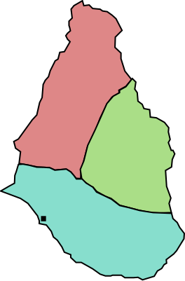
English: A map of the three parishes of the island of Montserrat. Saint Peter is shown in pale red, Saint Georges in green and Saint Anthony in blue. The black square marks Plymouth, the island's capital. Based on http://www.statoids.com/mms.html, however, map data is not detailed enough to have copyright implications. |
| Datum | |
| Bron | Eigen werk |
| Auteur | Jarry1250 |
| Andere versies | Afgeleide werken van dit bestand: Montserrat location map.svg |
| SVG ontwikkeling | De broncode van dit SVG-bestand is deugdelijk. |
Licentie
| Ik, de auteursrechthebbende van dit werk, geef dit werk vrij in het publieke domein. Dit is wereldwijd van toepassing. In sommige landen is dit wettelijk niet mogelijk; in die gevallen geldt: Ik sta iedereen toe dit werk voor eender welk doel te gebruiken, zonder enige voorwaarden, tenzij zulke voorwaarden door de wet worden voorgeschreven. |
Bestandsgeschiedenis
Klik op een datum/tijd om het bestand te zien zoals het destijds was.
| Datum/tijd | Miniatuur | Afmetingen | Gebruiker | Opmerking | |
|---|---|---|---|---|---|
| huidige versie | 26 okt 2009 21:42 | | 264 × 401 (7 kB) | Jarry1250 | {{Information |Description={{en|1=A map of the three parishes of the island of w:Montserrat. Saint Peter is shown in pale red, Saint Georges in green and Saint Anthony in blue. The black square marks Plymouth, the island's |
Bestandsgebruik
Dit bestand wordt op de volgende pagina gebruikt:
Globaal bestandsgebruik
De volgende andere wiki's gebruiken dit bestand:
- Gebruikt op ar.wikipedia.org
- Gebruikt op ba.wikipedia.org
- Gebruikt op de.wikipedia.org
- Gebruikt op en.wikipedia.org
- Gebruikt op es.wikipedia.org
- Gebruikt op fr.wikipedia.org
- Gebruikt op id.wikipedia.org
- Gebruikt op is.wikipedia.org
- Gebruikt op ja.wikipedia.org
- Gebruikt op kk.wikipedia.org
- Gebruikt op lt.wikipedia.org
- Gebruikt op ml.wikipedia.org
- Gebruikt op mt.wikipedia.org
- Gebruikt op ru.wikipedia.org
- Gebruikt op uk.wikipedia.org
- Gebruikt op vi.wikipedia.org
- Gebruikt op zh.wikipedia.org