
Bestand:Plan Nicholsona.jpg
Oorspronkelijk bestand (6.092 × 4.849 pixels, bestandsgrootte: 8,25 MB, MIME-type: image/jpeg)
| Dit is een bestand van Wikimedia Commons. Onderstaande beschrijving komt van de beschrijving van het bestand daar. |
Beschrijving
| Auteur |
Drawn by
|
|||||||||||||||||||||||
| Beschrijving |
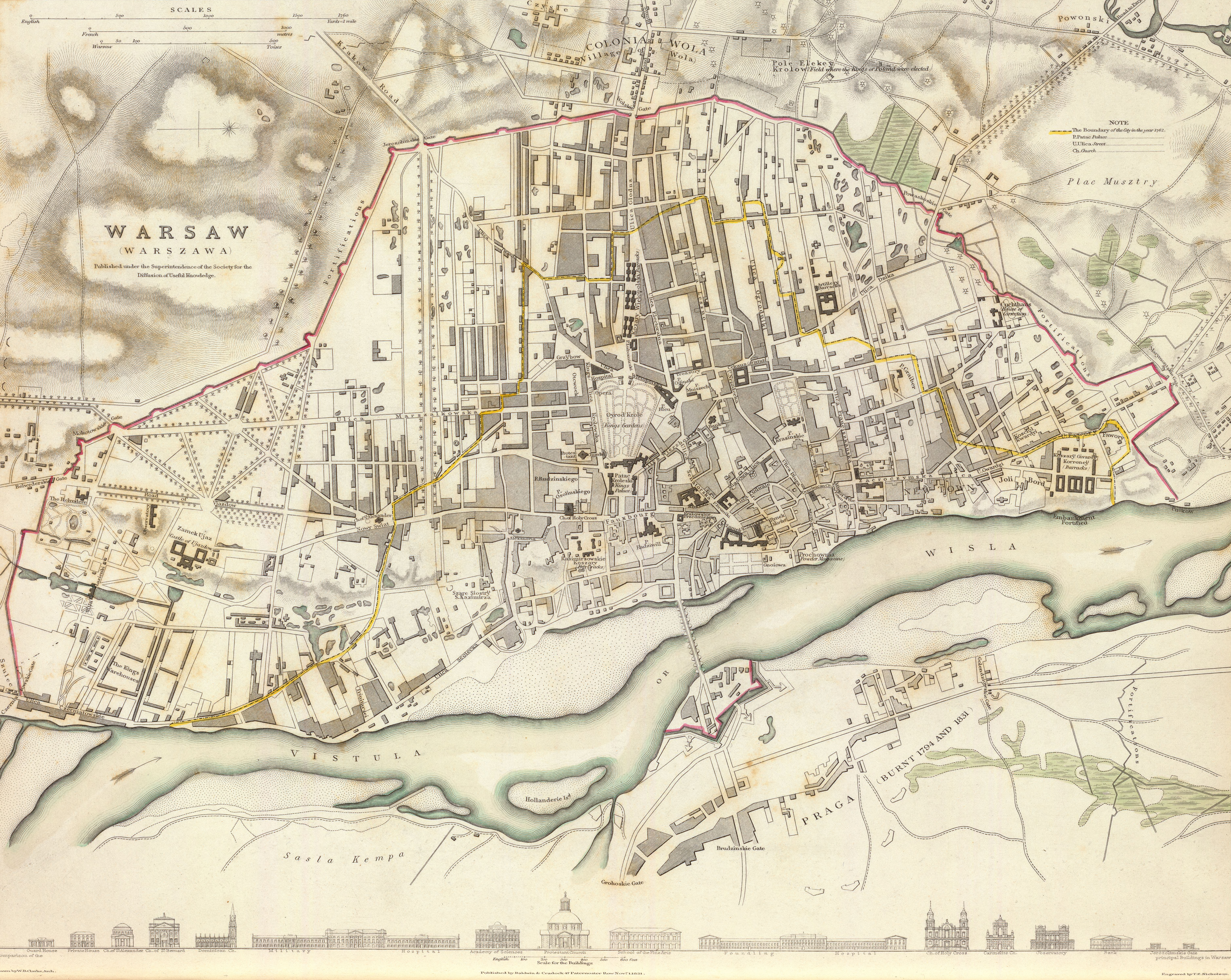
English: 1831 map of Warsaw, Poland, the so-called "Nicholson's Plan"
Note that the map is neither very accurate in terms of precision [1] nor in proper place names. Many if not most have been misspelt (Oyrod Krole park should be Ogród Królewski, Kozary Wielopolski (six buildings to the north of the park) should be called Koszary Wielopolskie, Cekauz (Arsenal) => Cekhauz, Patac Kroleski => Pałac Królewski and so on). Downloaded from David Rumsey's site ([2]), converted from .sid to .tiff format with mrsidgeodecode and then to .jpg with Adobe PS.Polski: Plan Warszawy z roku 1831, tzw. Plan Nicholsona
Plan jest względnie niedokładny, zarówno jeśli chodzi o precyzję jak i nazwy własne[3]. Wiele z nich zostało przekręconych (na przykład "Oyrod Krole" zamiast "Ogród Królewski", "Kozary Wielopolski" w miejsce "Koszarów Wielopolskich", "Cekauz" zamiast "Cekhauz", "Patac Kroleski" zamiast "Pałac Królewski" itd.). Mapa pobrana ze strony Davida Rumseya ([4]), przekonwertowana z formatu .sid do .tiff za pomocą mrsidgeodecode, a następnie do formatu .jpg z użyciem Adobe Photoshop. |
|||||||||||||||||||||||
| Datum | 1 november 1831 | |||||||||||||||||||||||
| Techniek | gravure | |||||||||||||||||||||||
| Afmetingen | hoogte: 30 cm; breedte: 38 cm | |||||||||||||||||||||||
| Inscripties | Published under the superintendence of the Society for the Diffusion of Useful Knowledge. Drawn by W.B. Clarke, archt. Engraved by T.E. Nicholson. Published by Baldwin & Cradock, 47 Paternoster Row, Novr. 1, 1831. (London: Chapman & Hall, 1844) | |||||||||||||||||||||||
| Bron/fotograaf | [5] | |||||||||||||||||||||||
| Andere versies |
|
|||||||||||||||||||||||

Licentie
|
Dit werk bevindt zich in het publiek domein in landen en gebieden waar de auteursrechttermijn het leven van de auteur plus 100 jaar of minder is. | |
| Van dit bestand is vastgesteld dat er geen bekende auteursrechtaanspraken op rusten, alle aanverwante en naburige rechten daarbij inbegrepen. | |
Dit werk bevindt zich in het publiek domein in de Verenigde Staten omdat het gepubliceerd werd (of geregistreerd bij de U.S. Copyright Office) voor 1 januari 1929.
Werken in het publiek domein moeten zowel vrij van auteursrechten zijn in de Verenigde Staten als in het land van herkomst van het werk om te worden gehost op Commons. Indien het werk geen Amerikaans werk is, moet het bestand een aanvullende copyright tag hebben met de auteursrechtelijke status in het land van herkomst.
|
| Aantekeningen | Deze afbeelding is aangetekend: Bekijk de aantekeningen op Commons |
Bestandsgeschiedenis
Klik op een datum/tijd om het bestand te zien zoals het destijds was.
| Datum/tijd | Miniatuur | Afmetingen | Gebruiker | Opmerking | |
|---|---|---|---|---|---|
| huidige versie | 18 sep 2011 01:30 | | 6.092 × 4.849 (8,25 MB) | Halibutt |
Bestandsgebruik
Dit bestand wordt op de volgende pagina gebruikt:
Globaal bestandsgebruik
De volgende andere wiki's gebruiken dit bestand:
- Gebruikt op azb.wikipedia.org
- Gebruikt op en.wikipedia.org
- Gebruikt op eu.wikipedia.org
- Gebruikt op pl.wikipedia.org
- Gebruikt op ro.wikipedia.org
- Gebruikt op ru.wikipedia.org
- Gebruikt op uk.wikipedia.org
- Gebruikt op vi.wikipedia.org