
Bestand:Porquerolles topographic map-fr.svg

Afmetingen van deze voorvertoning van het type PNG van dit SVG-bestand: 800 × 563 pixels Andere resoluties: 320 × 225 pixels | 640 × 451 pixels | 1.024 × 721 pixels | 1.280 × 901 pixels | 2.560 × 1.802 pixels | 1.027 × 723 pixels.
Oorspronkelijk bestand (SVG-bestand, nominaal 1.027 × 723 pixels, bestandsgrootte: 1,15 MB)
| Dit is een bestand van Wikimedia Commons. Onderstaande beschrijving komt van de beschrijving van het bestand daar. |
| Beschrijving |
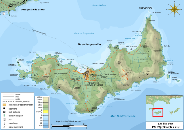
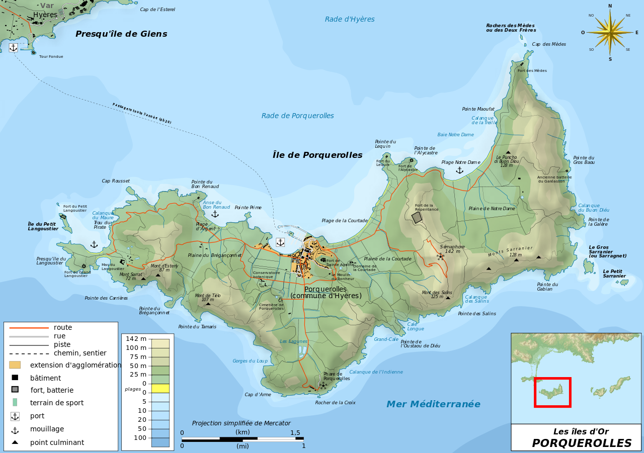
Français : Carte topographique et administrative en français de Porquerolles, l'une des trois Îles d'Or, ou Îles d'Hyères. Deutsch: Topographische Karte / Verwaltungskarte zum Porquerolles, in Französische English: Topographic and administrative map in French of Porquerolles Español: Mapa topográfico y administrativo en francès de Porquerolles Italiano: Carta topografica e amministrativa de Porquerolles 日本語: フランス語で表示したPorquerollesの地形·行政地図 Português: Carta topográfica e da administração do Porquerolles em francês |
||||
| Datum | |||||
| Bron |
Français : Création personnelle ;
English: Own work;
|
||||
| Auteur | Bourrichon - fr:Bourrichon | ||||
| Toestemming (Hergebruik van dit bestand) |
Ik, de auteursrechthebbende van dit werk, maak het hierbij onder de volgende licenties beschikbaar:
Dit bestand is gelicenseerd onder de Creative Commons-licenties Naamsvermelding-Gelijk delen 3.0 Unported, 2.5 Algemeen, 2.0 Algemeen en 1.0 Algemeen.
U mag zelf één van de licenties kiezen. |
||||
| Andere versies | Template:Other versions/Porquerolles map |


|
Dit SVG-bestand maakt gebruik van geïntegreerde tekst die gemakkelijk kan worden vertaald naar uw taal met een SVG editor, een tekstverwerker of het hulpmiddel SVG Translate. Uitleg |
Deze niet W3C-verklaarde vectorafbeelding is gemaakt met Inkscape .
Bestandsgeschiedenis
Klik op een datum/tijd om het bestand te zien zoals het destijds was.
| Datum/tijd | Miniatuur | Afmetingen | Gebruiker | Opmerking | |
|---|---|---|---|---|---|
| huidige versie | 25 feb 2011 12:27 | | 1.027 × 723 (1,15 MB) | Bourrichon | harmonisation bathymétrie |
| 13 dec 2010 12:04 |  | 1.027 × 723 (1,15 MB) | Hektor | Added Mas du Langoustier | |
| 13 nov 2010 15:27 |  | 1.027 × 723 (1,15 MB) | Bourrichon | +corr orth => "Rade d'Hyères" | |
| 13 nov 2010 15:08 |  | 1.027 × 723 (1,15 MB) | Bourrichon | +erreur dans le nom de la projection => proj. simplifiée de Mercator | |
| 13 nov 2010 14:48 |  | 1.027 × 723 (1,15 MB) | Bourrichon | +correction de détails | |
| 4 nov 2010 23:18 |  | 1.027 × 723 (1,13 MB) | Bourrichon | debug | |
| 3 nov 2010 18:43 |  | 1.027 × 723 (1,15 MB) | Bourrichon | +Bathymétrie | |
| 2 nov 2010 21:08 |  | 1.003 × 723 (1,09 MB) | Bourrichon | embedded raster | |
| 2 nov 2010 21:05 |  | 1.003 × 723 (1,09 MB) | Bourrichon | +titre | |
| 2 nov 2010 20:36 |  | 1.003 × 723 (1,09 MB) | Bourrichon | debug |
Bestandsgebruik
Dit bestand wordt op de volgende pagina gebruikt:
Globaal bestandsgebruik
De volgende andere wiki's gebruiken dit bestand:
- Gebruikt op da.wikipedia.org
- Gebruikt op de.wikipedia.org
- Gebruikt op el.wikipedia.org
- Gebruikt op en.wikipedia.org
- Gebruikt op fr.wikipedia.org
- Gebruikt op it.wikipedia.org
- Gebruikt op lb.wikipedia.org
- Gebruikt op no.wikipedia.org
- Gebruikt op oc.wikipedia.org
- Gebruikt op pl.wikipedia.org
- Gebruikt op pl.wikivoyage.org
- Gebruikt op pt.wikipedia.org
- Gebruikt op ru.wikipedia.org
- Gebruikt op sv.wikipedia.org
- Gebruikt op tg.wikipedia.org
- Gebruikt op uk.wikipedia.org