
Bestand:Ptolemaeus Magna Germania.jpg
Grootte van deze voorvertoning: 800 × 575 pixels. Andere resoluties: 320 × 230 pixels | 640 × 460 pixels | 1.024 × 736 pixels | 1.280 × 920 pixels | 2.560 × 1.840 pixels | 5.440 × 3.909 pixels.
Oorspronkelijk bestand (5.440 × 3.909 pixels, bestandsgrootte: 27,13 MB, MIME-type: image/jpeg)
| Dit is een bestand van Wikimedia Commons. Onderstaande beschrijving komt van de beschrijving van het bestand daar. |
Beschrijving
| Beschrijving |
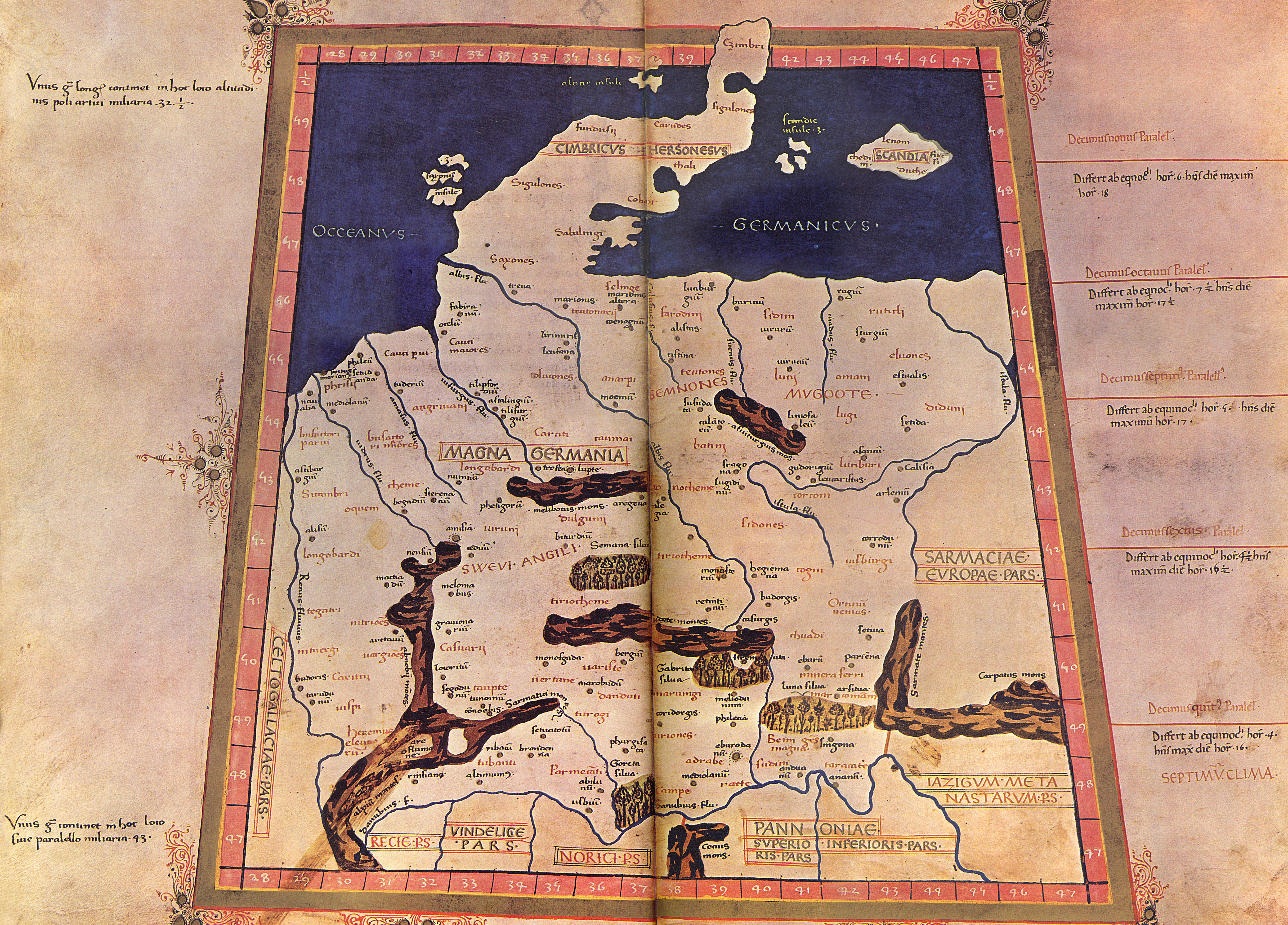
English: The 4th Map of Europe from Ptolemy's Geography, depicting Germany. - The Codex Latinus V. F. 32 is a manuscript edition of Ptolemy's Geography held by the National Library at Naples, Italy. It was photographed for publication in Cosmographia, intro. by Lelio Pagani and photog. by Domenico Lucchetti, in 1975 and 1990. - This is the only map of this Codex currently held in Commons.
Deutsch: EVROPA TABVLA QVARTA – Quarta Europe Tabula continet Germaniam cum insulis sibi adiacentibus. Die Karte zu Magna Germania aus der im Original griechisch verfaßten Geographike Hyphegesis des in Alexandria wirkenden Claudius Ptolemäus (*um 100; † um 175). Spätmittelalterliche Kopie des 15. Jahrhunderts die unter dem Titel Cosmographia erschien. Ptolemäus soll zwischen 125 und 151 tätig gewesen sein. Viele Wissenschaftler gehen davon aus, daß das Kartenwerk entweder vollständig oder zumindest teilweise in späterer Zeit auf der Grundlage des ptolemäischen Textes rekonstruiert worden ist. Der Codex Latinus V F.32 liegt in der Nationalbibliothek Neapel. Das Kartenwerk wird dem in Italien tätigen Deutschen Nicolaus Germanus zugeschrieben. |
||||||||||||||||
| Datum | 15. Jahrhundert/31. Oktober 2009 | ||||||||||||||||
| Bron | Eigen werk | ||||||||||||||||
| Auteur |
|
||||||||||||||||
| Andere versies |
  |
||||||||||||||||
Licentie
|
De auteur overleed in 1490, dus dit werk bevindt zich in het publiek domein in landen en gebieden waar de auteursrechttermijn het leven van de auteur plus 100 jaar of minder is. Dit werk bevindt zich in het publiek domein in de Verenigde Staten omdat het gepubliceerd werd (of geregistreerd bij de U.S. Copyright Office) voor 1 januari 1929. | |
| Van dit bestand is vastgesteld dat er geen bekende auteursrechtaanspraken op rusten, alle aanverwante en naburige rechten daarbij inbegrepen. | |
Bestandsgeschiedenis
Klik op een datum/tijd om het bestand te zien zoals het destijds was.
| Datum/tijd | Miniatuur | Afmetingen | Gebruiker | Opmerking | |
|---|---|---|---|---|---|
| huidige versie | 31 okt 2009 23:20 | | 5.440 × 3.909 (27,13 MB) | Mediatus | {{Information |Description={{de|1=EVROPA TABVLA QVARTA – Quarta Europe Tabula continet Germaniam cum insulis sibi adiacentibus. Die Karte zu ''Magna Germania'' aus der im Original griechisch verfaßten ''Geographike Hyphegesis'' des in Alexandria wirke |
Bestandsgebruik
Dit bestand wordt op de volgende pagina gebruikt:
Globaal bestandsgebruik
De volgende andere wiki's gebruiken dit bestand:
- Gebruikt op als.wikipedia.org
- Gebruikt op ast.wikipedia.org
- Gebruikt op bg.wikipedia.org
- Gebruikt op br.wikipedia.org
- Gebruikt op ca.wikipedia.org
- Gebruikt op cs.wikipedia.org
- Gebruikt op da.wikipedia.org
- Gebruikt op da.wikibooks.org
- Gebruikt op de.wikipedia.org
- Artaunon
- Kalisia
- Arae Flaviae
- Germania magna
- Oppidum auf dem Staffelberg
- Leuphana
- Benutzer:Drekamu/Notizen
- Amisia
- Portal Diskussion:Mecklenburg-Vorpommern/Archiv/1
- Treva
- Viadrus
- Benutzer:Mediatus/Bilder
- Gauonarion
- Sousoudata
- Tarodunum
- Wikipedia:WikiProjekt Germanen/Toponymie
- Bikourgion
- Alisus
- Kandounon
- Tropaia Drousou
- Luppia
- Mersouion
- Aregelia
- Loupfourdon
- Karrodounon
- Wikipedia:WikiProjekt Germanen/Projekt
- Segodounon
- Alcimoennis
- Wikipedia:WikiProjekt Germanen
- Rougion
- Siatoutanda
- Fabiranum
- Tekelia
- Lirimeris
- Marionis
- Marionis altera
- Kenennon
- Mounition
- Lakibourgion
- Aitouia
- Ouirition
Globaal gebruik van dit bestand bekijken.