
Bestand:Serbia-WW1-4.jpg
Grootte van deze voorvertoning: 799 × 271 pixels. Andere resoluties: 320 × 109 pixels | 1.023 × 347 pixels.
Oorspronkelijk bestand (1.023 × 347 pixels, bestandsgrootte: 99 kB, MIME-type: image/jpeg)
| Dit is een bestand van Wikimedia Commons. Onderstaande beschrijving komt van de beschrijving van het bestand daar. |

|
This map has been uploaded by Electionworld from en.wikipedia.org to enable the |
Beschrijving
| Beschrijving |
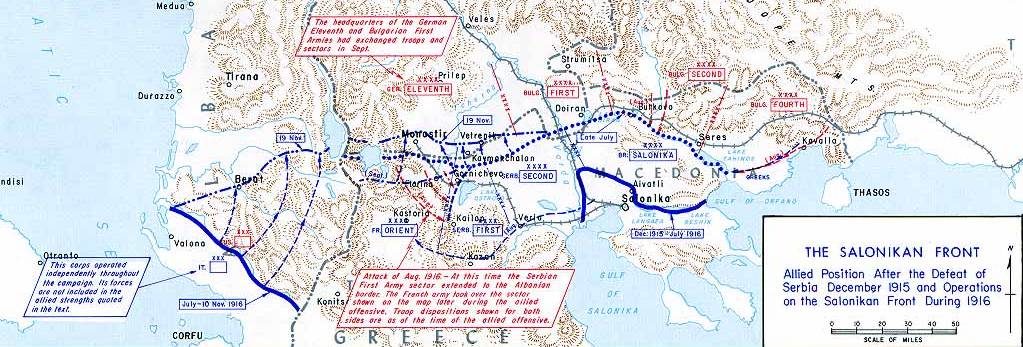
English: Operations at the border of Greece and Serbia, 1916.
his map was created by the Department of Military Art and Engineering, at the U.S. Military Academy (West Point). The initial version was created under the supervision of General Vincent Esposito in 1959. It is now available on the West Point |
||||||
| Datum | |||||||
| Bron | West Point | ||||||
| Auteur | General Vincent Esposito | ||||||
| Toestemming (Hergebruik van dit bestand) |
|
||||||
| Andere versies |
  |
||||||

Bestandsgeschiedenis
Klik op een datum/tijd om het bestand te zien zoals het destijds was.
| Datum/tijd | Miniatuur | Afmetingen | Gebruiker | Opmerking | |
|---|---|---|---|---|---|
| huidige versie | 21 dec 2006 23:55 | 1.023 × 347 (99 kB) | Electionworld | {{ew|en|Cglassey}} == Summary == Operations at the border of Greece and Serbia, 1916. his map was created by the Department of Military Art and Engineering, at the U.S. Military Academy (West Point). The initial version was created under the supervision |
Bestandsgebruik
Dit bestand wordt op de volgende pagina gebruikt:
Globaal bestandsgebruik
De volgende andere wiki's gebruiken dit bestand:
- Gebruikt op ar.wikipedia.org
- Gebruikt op azb.wikipedia.org
- Gebruikt op az.wikipedia.org
- Gebruikt op be-tarask.wikipedia.org
- Gebruikt op be.wikipedia.org
- Gebruikt op bg.wikipedia.org
- Gebruikt op bs.wikipedia.org
- Gebruikt op ca.wikipedia.org
- Gebruikt op de.wikipedia.org
- Gebruikt op el.wikipedia.org
- Gebruikt op en.wikipedia.org
- History of modern Macedonia (Greece)
- Maurice Sarrail
- Macedonian front
- Battle of Doiran (1917)
- Greece during World War I
- Monastir offensive
- Autonomous Province of Korçë
- Bulgarian occupation of Albania
- World War I in Albania
- Battle of the Crna Bend (1917)
- User:GerardM/Battles including the Ottoman Empire
- User:BoDr12/sandbox
- User:Falcaorib/Balkans maps
- User:Falcaorib/Serbia, Yugoslavia and Albania
- User:Falcaorib/Bulgaria and North Macedonia
- Gebruikt op es.wikipedia.org
- Gebruikt op fa.wikipedia.org
- Gebruikt op fr.wikipedia.org
- Gebruikt op he.wikipedia.org
Globaal gebruik van dit bestand bekijken.