
Bestand:St Catherine's Lighthouse - geograph.org.uk - 1414472.jpg
Grootte van deze voorvertoning: 450 × 600 pixels. Andere resoluties: 180 × 240 pixels | 480 × 640 pixels.
Oorspronkelijk bestand (480 × 640 pixels, bestandsgrootte: 40 kB, MIME-type: image/jpeg)
| Dit is een bestand van Wikimedia Commons. Onderstaande beschrijving komt van de beschrijving van het bestand daar. |
Beschrijving
| Beschrijving |
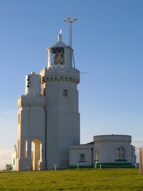
English: St Catherine's Lighthouse Like most lighthouses, it's an attractive structure, also shown at https://www.geograph.org.uk/gridref/SZ4975?class=Lighthouse&nl=1 . "Built 1838-40. Designed by Walker and Burgess and altered in 1875 when, on account of mist the height was reduced to 86 feet by the removal of the upper stage and part of the middle stage. Stuccoed octagonal tower of 2 stages. Machicolations and castellated parapet surmounted by conical light and ball finial and weathervane. In 1932 a lower tower of 2 storeys, reproducing the design of the main lighthouse as shortened, but with an open arcade on the ground floor, was added on the south side to mount the foghorn. These 2 towers are known locally as the Cow and the Calf. To the west of the main Lighthouse tower is a doorway with the date 1838 over it and a projection on the ground floor with gable above {this can be seen on the left}. Attached to the east is the Head Lighthouse keeper's house of 1 storey with curved front and round headed window facing east. This lighthouse was one of the first in the world to be illuminated by electric light being fitted with it in 1888 ... St Catherine's lighthouse was built as a result of the wreck of the 'Clarendon' in Chale Bay on the 11th October 1836. " http://www.imagesofengland.org.uk/details/default.aspx?id=392863 |
| Datum | |
| Bron | From geograph.org.uk |
| Auteur | Derek Harper |
| Naamsvermelding (required by the license) | Derek Harper / St Catherine's Lighthouse / |
| Cameralocatie | | Deze en andere afbeeldingen in: OpenStreetMap |
|---|
_heading:270.00&language=nl)
| Objectlocatie | | Deze en andere afbeeldingen in: OpenStreetMap |
|---|
_heading:270.00&language=nl)
Licentie

|
Deze afbeelding komt uit de Geograph British Isles-collectie. Zie de pagina van deze foto op de website van Geograph voor contactinformatie van de fotograaf. Het auteursrecht van deze foto is in handen van Derek Harper en de foto is gelicenceerd voor hergebruik onder de Creative Commons Naamsvermelding-Gelijk delen 2.0 licentie.
|
Dit bestand is gelicenseerd onder de Creative Commons-licentie Naamsvermelding-Gelijk delen 2.0 Unported
Naamsvermelding: Derek Harper
- De gebruiker mag:
- Delen – het werk kopiëren, verspreiden en doorgeven
- Remixen – afgeleide werken maken
- Onder de volgende voorwaarden:
- naamsvermelding – U moet op een gepaste manier aan naamsvermelding doen, een link naar de licentie geven, en aangeven of er wijzigingen in het werk zijn aangebracht. U mag dit op elke redelijke manier doen, maar niet zodanig dat de indruk wordt gewekt dat de licentiegever instemt met uw werk of uw gebruik van zijn werk.
- Gelijk delen – Als u het werk heeft geremixt, veranderd, of erop heeft voortgebouwd, moet u het gewijzigde materiaal verspreiden onder dezelfde licentie als het oorspronkelijke werk, of een daarmee compatibele licentie.
Bestandsgeschiedenis
Klik op een datum/tijd om het bestand te zien zoals het destijds was.
| Datum/tijd | Miniatuur | Afmetingen | Gebruiker | Opmerking | |
|---|---|---|---|---|---|
| huidige versie | 1 mrt 2011 19:01 | | 480 × 640 (40 kB) | GeographBot | == {{int:filedesc}} == {{Information |description={{en|1=St Catherine's Lighthouse Like most lighthouses, it's an attractive structure, also shown at http://www.geograph.org.uk/gridref/SZ4975?class=Lighthouse&nl=1 . "Built 1838-40. Designed by Walker and |
Bestandsgebruik
Dit bestand wordt op de volgende pagina gebruikt:
Globaal bestandsgebruik
De volgende andere wiki's gebruiken dit bestand:
- Gebruikt op fr.wikipedia.org