
Bestand:Suez canal map.jpg
Geen hogere resolutie beschikbaar.
Suez_canal_map.jpg (500 × 582 pixels, bestandsgrootte: 107 kB, MIME-type: image/jpeg)
| Dit is een bestand van Wikimedia Commons. Onderstaande beschrijving komt van de beschrijving van het bestand daar. |
Beschrijving
| Beschrijving |
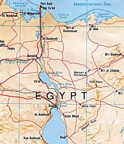
English: Map of the Suez canal extracted from a map of the Sinai Peninsula. |
| Datum | |
| Bron |
University of Texas Libraries, Perry-Castañeda Library Map Collection: Egypt Maps, Egypt - Sinai Peninsula (Shaded Relief) 1992 |
| Auteur | CIA |
| Andere versies | , Arabic Derivative |

Licentie
| This image is a work of a Central Intelligence Agency employee, taken or made as part of that person's official duties. As a Work of the United States Government, this image or media is in the public domain in the United States.
|

|
| Aantekeningen | Deze afbeelding is aangetekend: Bekijk de aantekeningen op Commons |
Bestandsgeschiedenis
Klik op een datum/tijd om het bestand te zien zoals het destijds was.
| Datum/tijd | Miniatuur | Afmetingen | Gebruiker | Opmerking | |
|---|---|---|---|---|---|
| huidige versie | 29 mei 2007 22:04 | | 500 × 582 (107 kB) | Orlovic | Cropped from here: http://commons.wikimedia.org/wiki/Image:Sinai-peninsula-map.jpg Category:Suez Canal |
Bestandsgebruik
Dit bestand wordt op de volgende 2 pagina's gebruikt:
Globaal bestandsgebruik
De volgende andere wiki's gebruiken dit bestand:
- Gebruikt op af.wikipedia.org
- Gebruikt op ar.wikipedia.org
- Gebruikt op azb.wikipedia.org
- Gebruikt op az.wikipedia.org
- Gebruikt op bn.wikipedia.org
- Gebruikt op ca.wikipedia.org
- Gebruikt op cs.wikipedia.org
- Gebruikt op da.wikipedia.org
- Gebruikt op de.wikipedia.org
- Gebruikt op en.wikipedia.org
- Gebruikt op es.wikipedia.org
- Gebruikt op eu.wikipedia.org
- Gebruikt op fa.wikipedia.org
- Gebruikt op fi.wikipedia.org
- Gebruikt op fr.wikipedia.org
- Gebruikt op he.wikipedia.org
- Gebruikt op id.wikipedia.org
- Gebruikt op it.wikipedia.org
- Gebruikt op ja.wikipedia.org
- Gebruikt op no.wikipedia.org
- Gebruikt op pl.wiktionary.org
- Gebruikt op pnb.wikipedia.org
- Gebruikt op pt.wikipedia.org
- Gebruikt op ru.wikipedia.org
- Gebruikt op sh.wikipedia.org
- Gebruikt op simple.wikipedia.org
- Gebruikt op sk.wikipedia.org
- Gebruikt op sq.wikipedia.org
- Gebruikt op sr.wikipedia.org
- Gebruikt op sv.wikipedia.org
- Gebruikt op ta.wikipedia.org
- Gebruikt op tr.wikipedia.org
- Gebruikt op uk.wikipedia.org
- Gebruikt op www.wikidata.org
- Gebruikt op zh.wikipedia.org