
Bestand:Togo location map Topographic.png
Grootte van deze voorvertoning: 408 × 600 pixels. Andere resoluties: 163 × 240 pixels | 326 × 480 pixels | 717 × 1.054 pixels.
Oorspronkelijk bestand (717 × 1.054 pixels, bestandsgrootte: 1,17 MB, MIME-type: image/png)
| Dit is een bestand van Wikimedia Commons. Onderstaande beschrijving komt van de beschrijving van het bestand daar. |
Beschrijving
| Beschrijving |
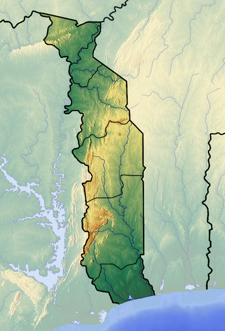
Français : Carte topographique du Togo |
| Datum | |
| Bron | Eigen werk (backgroung : http://www.maps-for-free.com) |
| Auteur | Dr Brains |
Licentie
Ik, de auteursrechthebbende van dit werk, maak het hierbij onder de volgende licenties beschikbaar:

|
Toestemming wordt verleend voor het kopiëren, verspreiden en/of wijzigen van dit document onder de voorwaarden van de GNU-licentie voor vrije documentatie, alleen versie 1.2 als gepubliceerd door de Free Software Foundation; zonder Invariant Sections, zonder Front-Cover Texts, en zonder Back-Cover Texts. Een kopie van de licentie is opgenomen in de sectie GNU-licentie voor vrije documentatie. | alleen 1.2 |
|
|
Toestemming wordt verleend voor het kopiëren, verspreiden en/of wijzigen van dit document onder de voorwaarden van de GNU-licentie voor vrije documentatie, versie 1.3 of enige latere versie als gepubliceerd door de Free Software Foundation; zonder Invariant Sections, zonder Front-Cover Texts, en zonder Back-Cover Texts. Een kopie van de licentie is opgenomen in de sectie GNU-licentie voor vrije documentatie.
|
If this file is eligible for relicensing, it may also be used under the Creative Commons Attribution-ShareAlike 3.0 license. The relicensing status of this image needs to be manually reviewed by an experienced user. You can help.
|
U mag zelf één van de licenties kiezen.
Bestandsgeschiedenis
Klik op een datum/tijd om het bestand te zien zoals het destijds was.
| Datum/tijd | Miniatuur | Afmetingen | Gebruiker | Opmerking | |
|---|---|---|---|---|---|
| huidige versie | 26 jun 2012 16:04 | | 717 × 1.054 (1,17 MB) | Dark Attsios | pleine résolution (erreur de ma part) |
| 26 jun 2012 15:38 |  | 408 × 599 (411 kB) | Dark Attsios | réajustement de la carte pour concorder avec le fichier svg | |
| 11 jun 2012 23:27 |  | 722 × 1.057 (1,17 MB) | Dr Brains |
Bestandsgebruik
Dit bestand wordt op de volgende 2 pagina's gebruikt:
Globaal bestandsgebruik
De volgende andere wiki's gebruiken dit bestand:
- Gebruikt op ar.wikipedia.org
- Gebruikt op ast.wikipedia.org
- Gebruikt op az.wikipedia.org
- Gebruikt op ba.wikipedia.org
- Gebruikt op bcl.wikipedia.org
- Gebruikt op be.wikipedia.org
- Gebruikt op bg.wikipedia.org
- Gebruikt op bn.wikipedia.org
- Gebruikt op bs.wikipedia.org
- Gebruikt op ca.wikipedia.org
- Gebruikt op ceb.wikipedia.org
- Gebruikt op cs.wikipedia.org
- Gebruikt op da.wikipedia.org
- Gebruikt op de.wikipedia.org
- Gebruikt op el.wikipedia.org
- Gebruikt op en.wikipedia.org
- Mount Agou
- Kéran National Park
- Fazao Malfakassa National Park
- Abdoulaye Faunal Reserve
- Module:Location map/data/Togo/doc
- 1963 Togolese coup d'état
- Geology of Togo
- Nangbeto Dam
- Fosse aux Lions National Park
- Module:Location map/data/Togo
- List of fossiliferous stratigraphic units in Togo
- 1967 Togolese coup d'état
- 1986 Togolese coup attempt
- Gebruikt op eo.wikipedia.org
- Gebruikt op fa.wikipedia.org
Globaal gebruik van dit bestand bekijken.