
Bestand:Tramlink map 2017.png

Grootte van deze voorvertoning: 800 × 439 pixels. Andere resoluties: 320 × 176 pixels | 640 × 352 pixels | 1.024 × 562 pixels | 1.280 × 703 pixels | 2.560 × 1.406 pixels | 5.526 × 3.035 pixels.
Oorspronkelijk bestand (5.526 × 3.035 pixels, bestandsgrootte: 1,31 MB, MIME-type: image/png)
| Dit is een bestand van Wikimedia Commons. Onderstaande beschrijving komt van de beschrijving van het bestand daar. |
Beschrijving
| Beschrijving |
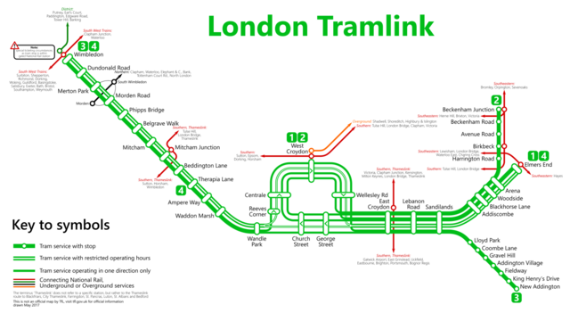
Deutsch: Karte der Londoner Straßenbahnen, Stand 2017
English: Map of the London tramlink as of 2017 |
| Datum | |
| Bron | Eigen werk |
| Auteur | Metrophil |
Licentie
Ik, de auteursrechthebbende van dit werk, maak het hierbij onder de volgende licentie beschikbaar:
Dit bestand is gelicenseerd onder de Creative Commons Naamsvermelding-GelijkDelen 4.0 Internationaal licentie.
- De gebruiker mag:
- Delen – het werk kopiëren, verspreiden en doorgeven
- Remixen – afgeleide werken maken
- Onder de volgende voorwaarden:
- naamsvermelding – U moet op een gepaste manier aan naamsvermelding doen, een link naar de licentie geven, en aangeven of er wijzigingen in het werk zijn aangebracht. U mag dit op elke redelijke manier doen, maar niet zodanig dat de indruk wordt gewekt dat de licentiegever instemt met uw werk of uw gebruik van zijn werk.
- Gelijk delen – Als u het werk heeft geremixt, veranderd, of erop heeft voortgebouwd, moet u het gewijzigde materiaal verspreiden onder dezelfde licentie als het oorspronkelijke werk, of een daarmee compatibele licentie.
Bestandsgeschiedenis
Klik op een datum/tijd om het bestand te zien zoals het destijds was.
| Datum/tijd | Miniatuur | Afmetingen | Gebruiker | Opmerking | |
|---|---|---|---|---|---|
| huidige versie | 25 mei 2017 17:50 | | 5.526 × 3.035 (1,31 MB) | Metrophil | minor |
| 25 mei 2017 17:44 |  | 5.526 × 3.035 (1,31 MB) | Metrophil | further corrections | |
| 20 mei 2017 13:51 |  | 5.526 × 3.035 (1,17 MB) | Metrophil | Completely redrawn | |
| 29 apr 2017 16:52 |  | 4.384 × 2.168 (479 kB) | Ciwilm | Absorbed Overground into rail and listed the service names on each rail line | |
| 11 nov 2016 02:58 |  | 4.192 × 2.170 (623 kB) | Ciwilm | Made correction, Willesden > Shepherd's Bush. Added destinations rather than bland 'Outside Greater London'. | |
| 16 mei 2016 19:51 |  | 14.556 × 7.534 (3,14 MB) | Metrophil | Minor corrections | |
| 7 mrt 2016 20:42 |  | 17.467 × 9.041 (3,88 MB) | Metrophil | User created page with UploadWizard |
Bestandsgebruik
Dit bestand wordt op de volgende pagina gebruikt:
Globaal bestandsgebruik
De volgende andere wiki's gebruiken dit bestand:
- Gebruikt op cy.wikipedia.org
- Gebruikt op da.wikipedia.org
- Gebruikt op de.wikipedia.org
- Gebruikt op eo.wikipedia.org
- Gebruikt op es.wikipedia.org
- Gebruikt op fa.wikipedia.org
- Gebruikt op fi.wikipedia.org
- Gebruikt op fr.wikipedia.org
- Gebruikt op gl.wikipedia.org
- Gebruikt op it.wikipedia.org
- Gebruikt op ko.wikipedia.org
- Gebruikt op lv.wikipedia.org
- Gebruikt op pnb.wikipedia.org
- Gebruikt op pt.wikipedia.org
- Gebruikt op ro.wikipedia.org
- Gebruikt op tr.wikipedia.org
- Gebruikt op ur.wikipedia.org
- Gebruikt op www.wikidata.org
- Gebruikt op yi.wikipedia.org