
Bestand:VIIRS view of the 2021 Suez Canal obstruction.jpg
Geen hogere resolutie beschikbaar.
VIIRS_view_of_the_2021_Suez_Canal_obstruction.jpg (720 × 480 pixels, bestandsgrootte: 80 kB, MIME-type: image/jpeg)
| Dit is een bestand van Wikimedia Commons. Onderstaande beschrijving komt van de beschrijving van het bestand daar. |
Beschrijving
| Beschrijving |
Español: Comparación del tráfico en el Canal de Suez antes y después del bloqueo causado por el Ever Given visto por el instrumento VIIRS del satélite Suomi National Polar-orbiting Partnership.
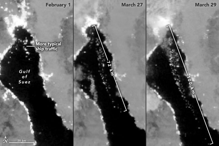
English: The series of nighttime images above, all acquired with the Visible Infrared Imaging Radiometer Suite (VIIRS) on the Suomi NPP satellite, offers another view of ships waiting in the Gulf of Suez. The VIIRS “day-night band” detects light in a range of wavelengths from green to near-infrared and uses filtering techniques to enhance dim signals such as moonlight, gas flares, and the lights on ships. The left image shows typical ship traffic in the Gulf of Suez on February 1, 2021. By March 27, the line of waiting ships stretched 72 kilometers (45 miles). Two days later, ships waited as far as 100 kilometers (60 miles) from the canal entry. According to Leth Agencies, 184 vessels were still waiting to get through on March 30. |
| Datum | |
| Bron | https://earthobservatory.nasa.gov/images/148114/traffic-jam-on-the-suez-canal?utm_source=TWITTER&utm_medium=NASAOcean&utm_campaign=NASASocial&linkId=114935299 |
| Auteur | NASA Earth Observatory images by Lauren Dauphin and Joshua Stevens, using Landsat data from the U.S. Geological Survey and VIIRS day-night band data from the Suomi National Polar-orbiting Partnership. |
Licentie
| Dit bestand bevindt zich in het publiek domein, omdat het gemaakt is door de NASA. In de reproductierichtlijnen van de NASA staat dat "NASA-materiaal niet beschermd wordt door auteursrecht, tenzij anders vermeld". | ||
 |
Waarschuwingen:
|
Bestandsgeschiedenis
Klik op een datum/tijd om het bestand te zien zoals het destijds was.
| Datum/tijd | Miniatuur | Afmetingen | Gebruiker | Opmerking | |
|---|---|---|---|---|---|
| huidige versie | 30 mrt 2021 20:15 | | 720 × 480 (80 kB) | BugWarp | Uploaded a work by NASA Earth Observatory images by Lauren Dauphin and Joshua Stevens, using Landsat data from the U.S. Geological Survey and VIIRS day-night band data from the Suomi National Polar-orbiting Partnership. from https://earthobservatory.nasa.gov/images/148114/traffic-jam-on-the-suez-canal?utm_source=TWITTER&utm_medium=NASAOcean&utm_campaign=NASASocial&linkId=114935299 with UploadWizard |
Bestandsgebruik
Dit bestand wordt op de volgende pagina gebruikt: