
Bestand:Victoria Docks 1872.jpg

Grootte van deze voorvertoning: 800 × 450 pixels. Andere resoluties: 320 × 180 pixels | 640 × 360 pixels | 1.176 × 662 pixels.
Oorspronkelijk bestand (1.176 × 662 pixels, bestandsgrootte: 316 kB, MIME-type: image/jpeg)
| Dit is een bestand van Wikimedia Commons. Onderstaande beschrijving komt van de beschrijving van het bestand daar. |
Beschrijving
| Beschrijving |
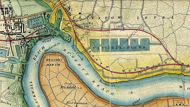
English: Map c.1872 showing Victoria Docks (now Royal Victoria Dock), Blackwall, the area that is now Canning Town and parts of the Greenwich Peninsula, London, UK. Also shows location of Thames Ironworks & Shipbuilding Company. |
|||||||||
| Datum | ca. 1872 | |||||||||
| Bron |
Wyld's New Topographical Map Of The Country In The Vicinity Of London c 1872.
|
|||||||||
| Maker |
Wyld's New Topographical Map Of The Country In The Vicinity Of London c 1872. |
|||||||||
| Geotemporal data | ||||||||||
| Bounding box |
|
|||||||||
| Georeferencing | ||||||||||
Licentie
Dit mediabestand is in het publiek domein in de Verenigde Staten van Amerika. Dit geldt voor werken uit de VS waarvan de copyright is verlopen, meestal omdat de eerste publicatie ervan verscheen voor 1 januari 1929. Zie ook deze pagina voor verdere uitleg
|
 | |
 |
Let op! Dit bestand hoeft niet in het publiek domein te zijn buiten de VS (dit geldt voor Canada, China (excl. Hong Kong, Macao of Taiwan), Duitsland, Mexico en Zwitserland). De auteur en het jaar van publicatie zijn essentiële informatie en moeten zijn vastgesteld. Zie ook Wikipedia:Public domain en Wikipedia:Copyrights voor meer informatie.
|
Oorspronkelijk uploadlogboek
De oorspronkelijke beschrijving van deze afbeelding stond hier. Alle volgende gebruikersnamen verwijzen naar en.wikipedia.
- 2010-06-26 18:51 SasiSasi 1176×662× (323144 bytes) {{Information |Description = Mapc.1872 showing Victoria Docks (now Royal Victoria Docks), the area that is now Canning Town and parts of the Greenwich Peninsula, London, UK |Source = http://archivemaps.com/mapco/wyld1872/wyld23.htm and http:/
Bestandsgeschiedenis
Klik op een datum/tijd om het bestand te zien zoals het destijds was.
| Datum/tijd | Miniatuur | Afmetingen | Gebruiker | Opmerking | |
|---|---|---|---|---|---|
| huidige versie | 17 mei 2011 12:56 | | 1.176 × 662 (316 kB) | File Upload Bot (Magnus Manske) | {{BotMoveToCommons|en.wikipedia|year={{subst:CURRENTYEAR}}|month={{subst:CURRENTMONTHNAME}}|day={{subst:CURRENTDAY}}}} {{Information |Description={{en|Mapc.1872 showing Victoria Docks (now Royal Victoria Docks), the area that is now Canning Town and part |
Bestandsgebruik
Dit bestand wordt op de volgende 2 pagina's gebruikt:
Globaal bestandsgebruik
De volgende andere wiki's gebruiken dit bestand:
- Gebruikt op arz.wikipedia.org
- Gebruikt op de.wikipedia.org
- Gebruikt op en.wikipedia.org
- Gebruikt op et.wikipedia.org
- Gebruikt op fi.wikipedia.org
- Gebruikt op fr.wikipedia.org
- Gebruikt op it.wikipedia.org
- Gebruikt op nn.wikipedia.org