
Bestand:Village centre of Mortsel, Belgium (aerial view).jpg

Grootte van deze voorvertoning: 800 × 465 pixels. Andere resoluties: 320 × 186 pixels | 640 × 372 pixels | 1.024 × 595 pixels | 1.280 × 744 pixels | 2.560 × 1.487 pixels | 3.869 × 2.248 pixels.
Oorspronkelijk bestand (3.869 × 2.248 pixels, bestandsgrootte: 3,34 MB, MIME-type: image/jpeg)
| Dit is een bestand van Wikimedia Commons. Onderstaande beschrijving komt van de beschrijving van het bestand daar. |
.jpg)
Beschrijving
| Beschrijving |
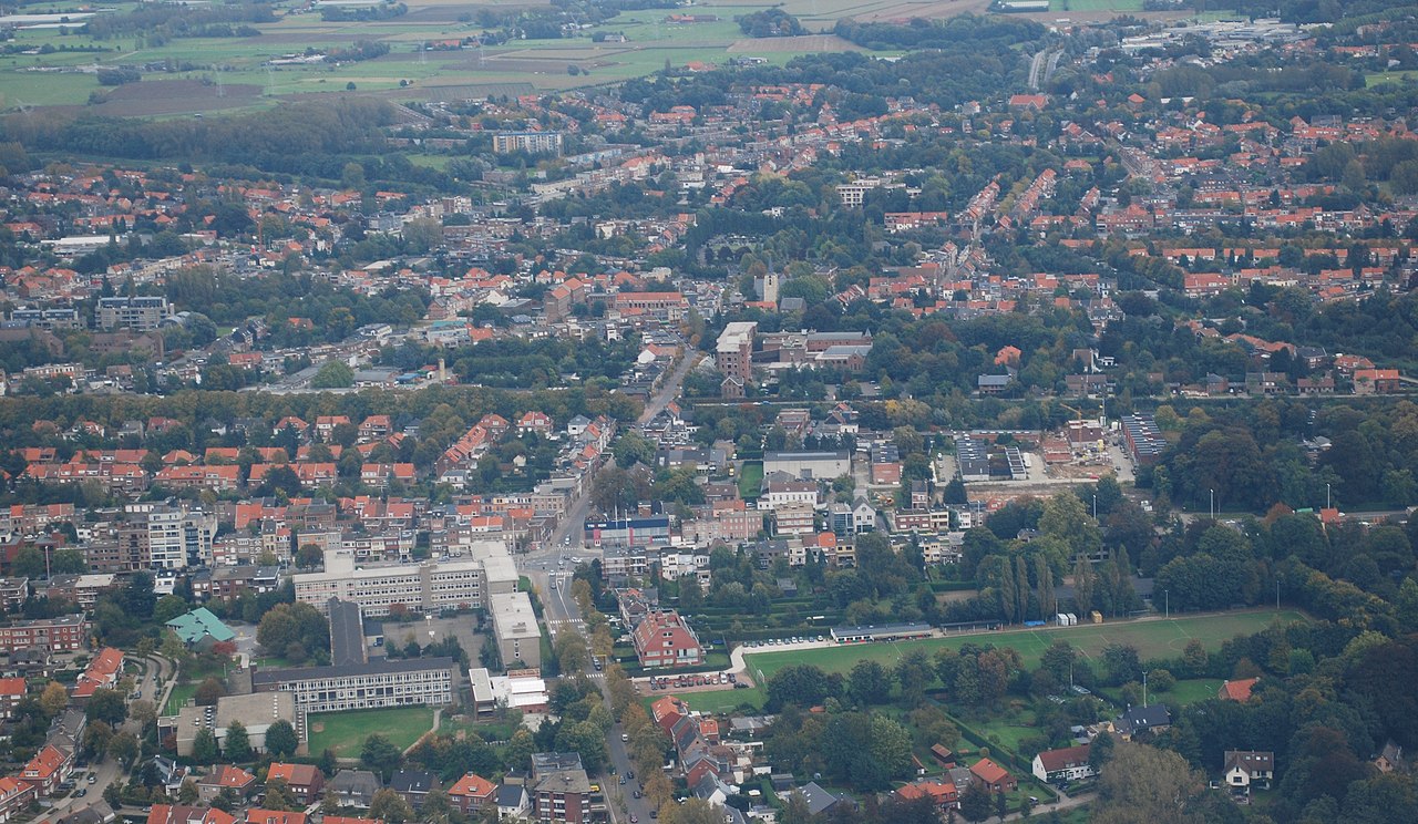
English: Aerial photograph from the West towards the centre of Mortsel. The near-horizontal line in the middle is the Antwerp-Brussels railroad. The red brick structure in front of the church is Saint Joseph's hospital. Nikon D60 f=48mm f/7.1 ISO 200 1/200s. Reframed and colour corrected using Adobe Photoshop 4.0.
Nederlands: Luchtfoto van de dorpskern van Mortsel vanuit het westen. De bijna horizontale lijn in het midden is de spoorweg Antwerpen-Brussel. Het rode bakstenen gebouw voor de kerk is het Sint-Jozefziekenhuis. Nikon D60 f=48mm f/7.1 ISO 200 1/200s. Cadrage en kleurcorrectie met Adobe Photoshop 4.0. |
| Datum | CEST |
| Bron | Eigen werk |
| Auteur | Lieven Smits |
Licentie
Ik, de auteursrechthebbende van dit werk, maak het hierbij onder de volgende licenties beschikbaar:

|
Toestemming wordt verleend voor het kopiëren, verspreiden en/of wijzigen van dit document onder de voorwaarden van de GNU-licentie voor vrije documentatie, versie 1.2 of enige latere versie als gepubliceerd door de Free Software Foundation; zonder Invariant Sections, zonder Front-Cover Texts, en zonder Back-Cover Texts. Een kopie van de licentie is opgenomen in de sectie GNU-licentie voor vrije documentatie. |
Dit bestand is gelicenseerd onder de Creative Commons-licenties Naamsvermelding-Gelijk delen 3.0 Unported, 2.5 Algemeen, 2.0 Algemeen en 1.0 Algemeen.
- De gebruiker mag:
- Delen – het werk kopiëren, verspreiden en doorgeven
- Remixen – afgeleide werken maken
- Onder de volgende voorwaarden:
- naamsvermelding – U moet op een gepaste manier aan naamsvermelding doen, een link naar de licentie geven, en aangeven of er wijzigingen in het werk zijn aangebracht. U mag dit op elke redelijke manier doen, maar niet zodanig dat de indruk wordt gewekt dat de licentiegever instemt met uw werk of uw gebruik van zijn werk.
- Gelijk delen – Als u het werk heeft geremixt, veranderd, of erop heeft voortgebouwd, moet u het gewijzigde materiaal verspreiden onder dezelfde licentie als het oorspronkelijke werk, of een daarmee compatibele licentie.
U mag zelf één van de licenties kiezen.
Bestandsgeschiedenis
Klik op een datum/tijd om het bestand te zien zoals het destijds was.
| Datum/tijd | Miniatuur | Afmetingen | Gebruiker | Opmerking | |
|---|---|---|---|---|---|
| huidige versie | 15 okt 2008 22:39 | | 3.869 × 2.248 (3,34 MB) | Lieven Smits | {{Information |Description={{en|1=Aerial photograph from the West towards the centre of Mortsel. The near-horizontal line in the middle is the Antwerp-Brussels railroad. The red brick structure in front of the church is Saint Joseph's hospital. Nikon D60 |
Bestandsgebruik
Dit bestand wordt op de volgende pagina gebruikt:
Globaal bestandsgebruik
De volgende andere wiki's gebruiken dit bestand:
- Gebruikt op ar.wikipedia.org
- Gebruikt op bg.wikipedia.org
- Gebruikt op br.wikipedia.org
- Gebruikt op ca.wikipedia.org
- Gebruikt op ceb.wikipedia.org
- Gebruikt op en.wikipedia.org
- Gebruikt op eo.wikipedia.org
- Gebruikt op es.wikipedia.org
- Gebruikt op eu.wikipedia.org
- Gebruikt op fa.wikipedia.org
- Gebruikt op ga.wikipedia.org
- Gebruikt op it.wikipedia.org
- Gebruikt op la.wikipedia.org
- Gebruikt op pt.wikipedia.org
- Gebruikt op ro.wikipedia.org
- Gebruikt op ru.wikipedia.org
- Gebruikt op sk.wikipedia.org
- Gebruikt op sv.wikipedia.org
- Gebruikt op tr.wikipedia.org
- Gebruikt op vi.wikipedia.org
- Gebruikt op www.wikidata.org
.jpg)