
Bestand:Xinjiang Internment Map, US-Aus Gov Assessment.jpg
Grootte van deze voorvertoning: 800 × 495 pixels. Andere resoluties: 320 × 198 pixels | 640 × 396 pixels | 1.024 × 634 pixels | 1.280 × 792 pixels | 2.048 × 1.267 pixels.
Oorspronkelijk bestand (2.048 × 1.267 pixels, bestandsgrootte: 150 kB, MIME-type: image/jpeg)
| Dit is een bestand van Wikimedia Commons. Onderstaande beschrijving komt van de beschrijving van het bestand daar. |
Beschrijving
| Beschrijving |
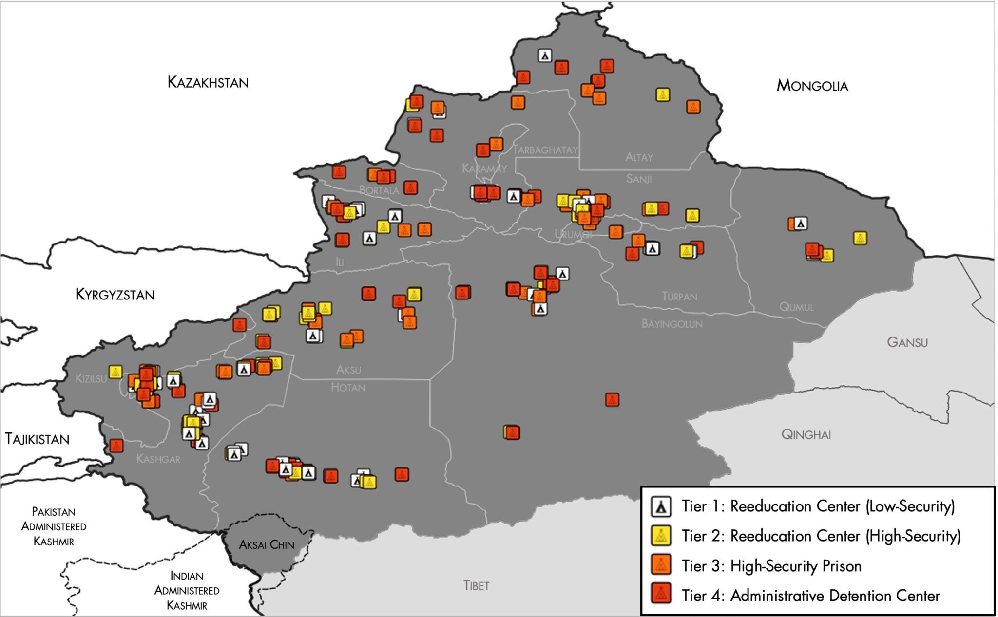
English: Map of the Xinjiang Internment Camps created by the RAND Corporation based on data collected by the US National Geospatial Intelligence Agency and the Australian Strategic Policy Institute. Open source here. |
||||||||
| Datum | |||||||||
| Bron | https://www.tearline.mil/public_page/xinjiang-nighttime-1/ | ||||||||
| Auteur | National Geospatial Intelligence Agency, using data from the Australian Strategic Policy Institute, and administrative boundaries from GADM. | ||||||||
| Toestemming (Hergebruik van dit bestand) |
|


Bestandsgeschiedenis
Klik op een datum/tijd om het bestand te zien zoals het destijds was.
| Datum/tijd | Miniatuur | Afmetingen | Gebruiker | Opmerking | |
|---|---|---|---|---|---|
| huidige versie | 2 mei 2021 07:05 | | 2.048 × 1.267 (150 kB) | Abovfold | Uploaded a work by {{w|National Geospatial Intelligence Agency}}, using data from the {{w|Australian Strategic Policy Institute}}, and administrative boundaries from {{w|GADM}}. from https://www.tearline.mil/public_page/xinjiang-nighttime-1/ with UploadWizard |
Bestandsgebruik
Dit bestand wordt op de volgende pagina gebruikt:
Globaal bestandsgebruik
De volgende andere wiki's gebruiken dit bestand:
- Gebruikt op ba.wikipedia.org
- Gebruikt op br.wikipedia.org
- Gebruikt op cs.wikipedia.org
- Gebruikt op de.wikipedia.org
- Gebruikt op el.wikipedia.org
- Gebruikt op en.wikipedia.org
- Gebruikt op es.wikipedia.org
- Gebruikt op fi.wikipedia.org
- Gebruikt op fr.wikipedia.org
- Gebruikt op ga.wikipedia.org
- Gebruikt op he.wikipedia.org
- Gebruikt op km.wikipedia.org
- Gebruikt op or.wikipedia.org
- Gebruikt op pl.wikipedia.org
- Gebruikt op pt.wikipedia.org
- Gebruikt op ru.wikinews.org
- Gebruikt op sv.wikipedia.org
- Gebruikt op szl.wikipedia.org
- Gebruikt op tr.wikipedia.org
- Gebruikt op www.wikidata.org