
Bestand:Carte du duché de Lorraine.svg

Afmetingen van deze voorvertoning van het type PNG van dit SVG-bestand: 568 × 600 pixels Andere resoluties: 227 × 240 pixels | 455 × 480 pixels | 727 × 768 pixels | 970 × 1.024 pixels | 1.940 × 2.048 pixels | 2.691 × 2.841 pixels.
Oorspronkelijk bestand (SVG-bestand, nominaal 2.691 × 2.841 pixels, bestandsgrootte: 831 kB)
| Dit is een bestand van Wikimedia Commons. Onderstaande beschrijving komt van de beschrijving van het bestand daar. |
Beschrijving
| Beschrijving |
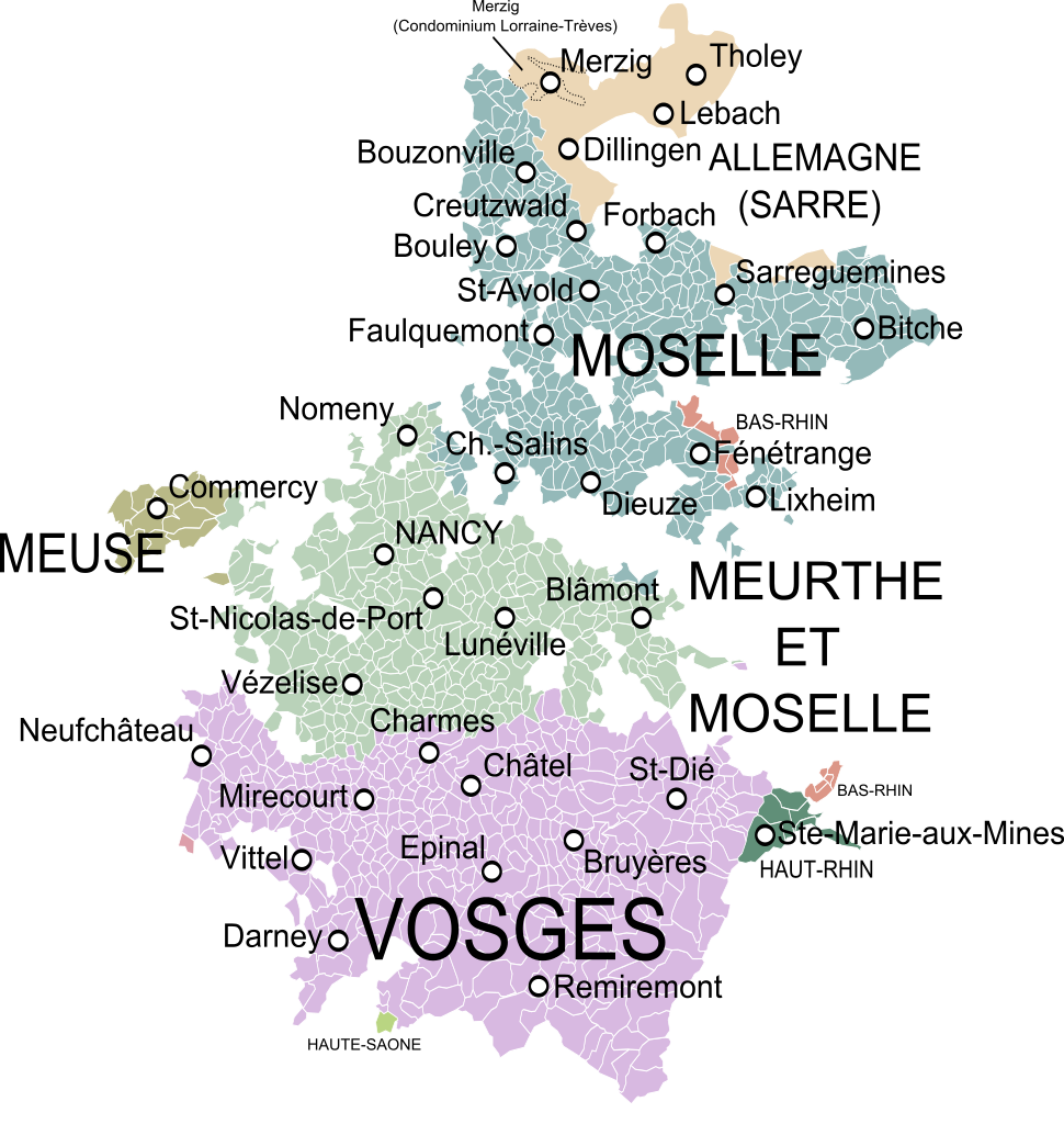
English: Map of the Duchy of Lorraine, France, showing the communes according to the current administrative division.
Français : Carte du duché de Lorraine (au milieu du XVIIIe siècle) montrant les communes et les départements actuels. |
| Datum | |
| Bron | Carte de la Lorraine et du Barrois dans laquelle se trouvent la Généralité de Metz et autres enclaves, Dressée pour la lecture du Mémoire de M. Durival l'ainé et dédiée au Roy de Pologne Duc de Lorraine et de Bar, Robert de Vaugondy, 1756. |
| Auteur | Oie blanche |
Licentie
Ik, de auteursrechthebbende van dit werk, maak het hierbij onder de volgende licenties beschikbaar:
Dit bestand is gelicenseerd onder de Creative Commons-licentie Naamsvermelding-Gelijk delen 3.0 Unported
- De gebruiker mag:
- Delen – het werk kopiëren, verspreiden en doorgeven
- Remixen – afgeleide werken maken
- Onder de volgende voorwaarden:
- naamsvermelding – U moet op een gepaste manier aan naamsvermelding doen, een link naar de licentie geven, en aangeven of er wijzigingen in het werk zijn aangebracht. U mag dit op elke redelijke manier doen, maar niet zodanig dat de indruk wordt gewekt dat de licentiegever instemt met uw werk of uw gebruik van zijn werk.
- Gelijk delen – Als u het werk heeft geremixt, veranderd, of erop heeft voortgebouwd, moet u het gewijzigde materiaal verspreiden onder dezelfde licentie als het oorspronkelijke werk, of een daarmee compatibele licentie.

|
Toestemming wordt verleend voor het kopiëren, verspreiden en/of wijzigen van dit document onder de voorwaarden van de GNU-licentie voor vrije documentatie, versie 1.2 of enige latere versie als gepubliceerd door de Free Software Foundation; zonder Invariant Sections, zonder Front-Cover Texts, en zonder Back-Cover Texts. Een kopie van de licentie is opgenomen in de sectie GNU-licentie voor vrije documentatie. |
U mag zelf één van de licenties kiezen.
Bestandsgeschiedenis
Klik op een datum/tijd om het bestand te zien zoals het destijds was.
| Datum/tijd | Miniatuur | Afmetingen | Gebruiker | Opmerking | |
|---|---|---|---|---|---|
| huidige versie | 5 dec 2013 00:12 | | 2.691 × 2.841 (831 kB) | Oie blanche | Minor edits. |
| 3 dec 2013 16:57 |  | 2.691 × 2.841 (792 kB) | Oie blanche | Minor edit. | |
| 3 dec 2013 15:42 |  | 2.691 × 2.841 (776 kB) | Oie blanche | Minor edit. | |
| 1 dec 2013 16:28 |  | 2.691 × 2.841 (855 kB) | Oie blanche | Minor correction. | |
| 1 dec 2013 16:23 |  | 2.691 × 2.841 (851 kB) | Oie blanche | {{Information |Description ={{en|1=Map of the Duchy of Lorraine, France, showing the communes according to the current administrative division.}} {{fr|1=Carte du duché de Lorraine montrant les communes et les départements actuels.}} |Source ... |
Bestandsgebruik
Dit bestand wordt op de volgende pagina gebruikt:
Globaal bestandsgebruik
De volgende andere wiki's gebruiken dit bestand:
- Gebruikt op de.wikipedia.org
- Gebruikt op en.wikipedia.org
- Gebruikt op es.wikipedia.org
- Gebruikt op fr.wikipedia.org
- Gebruikt op ko.wikipedia.org
- Gebruikt op lb.wikipedia.org
- Gebruikt op vi.wikipedia.org