
Bestand:England Administrative 1931.jpg

Grootte van deze voorvertoning: 488 × 600 pixels. Andere resoluties: 195 × 240 pixels | 391 × 480 pixels | 625 × 768 pixels | 833 × 1.024 pixels | 1.667 × 2.048 pixels | 5.300 × 6.512 pixels.
Oorspronkelijk bestand (5.300 × 6.512 pixels, bestandsgrootte: 3,07 MB, MIME-type: image/jpeg)
| Dit is een bestand van Wikimedia Commons. Onderstaande beschrijving komt van de beschrijving van het bestand daar. |
Beschrijving
| Beschrijving |
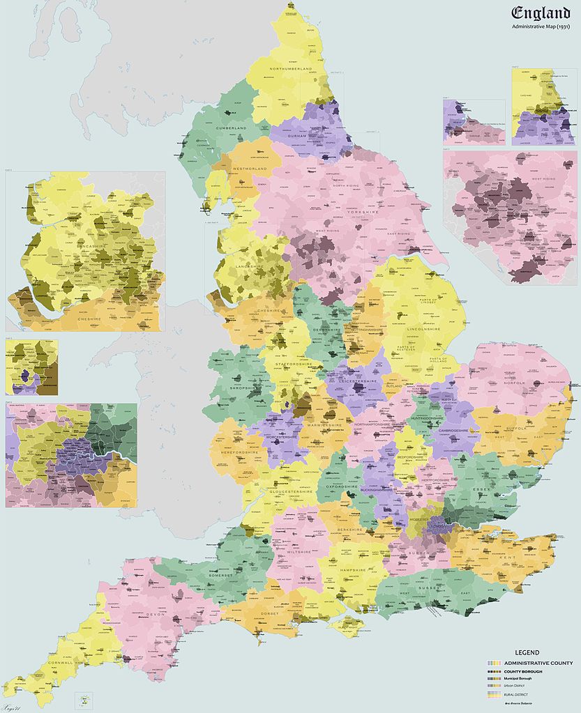
English: Administrative map of England in 1931. Shows Administrative Counties, County Boroughs, Municipal Boroughs, Urban and Rural Districts. |
| Datum | |
| Bron | Eigen werk |
| Auteur | XrysD |
| Andere versies | Afgeleide werken van dit bestand: England Administrative 1931 Unlabelled.png |
Licentie
Ik, de auteursrechthebbende van dit werk, maak het hierbij onder de volgende licenties beschikbaar:
Dit bestand is gelicenseerd onder de Creative Commons-licentie Naamsvermelding-Gelijk delen 3.0 Unported
- De gebruiker mag:
- Delen – het werk kopiëren, verspreiden en doorgeven
- Remixen – afgeleide werken maken
- Onder de volgende voorwaarden:
- naamsvermelding – U moet op een gepaste manier aan naamsvermelding doen, een link naar de licentie geven, en aangeven of er wijzigingen in het werk zijn aangebracht. U mag dit op elke redelijke manier doen, maar niet zodanig dat de indruk wordt gewekt dat de licentiegever instemt met uw werk of uw gebruik van zijn werk.
- Gelijk delen – Als u het werk heeft geremixt, veranderd, of erop heeft voortgebouwd, moet u het gewijzigde materiaal verspreiden onder dezelfde licentie als het oorspronkelijke werk, of een daarmee compatibele licentie.

|
Toestemming wordt verleend voor het kopiëren, verspreiden en/of wijzigen van dit document onder de voorwaarden van de GNU-licentie voor vrije documentatie, versie 1.2 of enige latere versie als gepubliceerd door de Free Software Foundation; zonder Invariant Sections, zonder Front-Cover Texts, en zonder Back-Cover Texts. Een kopie van de licentie is opgenomen in de sectie GNU-licentie voor vrije documentatie. |
U mag zelf één van de licenties kiezen.
Bestandsgeschiedenis
Klik op een datum/tijd om het bestand te zien zoals het destijds was.
| Datum/tijd | Miniatuur | Afmetingen | Gebruiker | Opmerking | |
|---|---|---|---|---|---|
| huidige versie | 6 mei 2011 22:23 | | 5.300 × 6.512 (3,07 MB) | XrysD | 1) Labelled district to the west of Wolverhampton CB (Tettenhall UD) 2) District wrongly labelled as Tettenhall MB changed to Brownhills UD. 3) Aldridge changed to UD 4) District between Smethwick CB and and Rowley Regis UD wrongly labelled as Bebington |
| 27 nov 2010 13:24 |  | 5.300 × 6.512 (3,06 MB) | XrysD | Fixed some typos in Hampshire. | |
| 20 aug 2010 20:52 |  | 5.300 × 6.512 (7,51 MB) | XrysD | {{Information |Description={{en|1=Administrative map of England in 1931. Shows Administrative Counties, County Boroughs, Municipal Boroughs, Urban and Rural Districts.}} |Source={{own}} |Author=XrysD |Date=2010-08-20 |Permission= |other_ver |
Bestandsgebruik
Dit bestand wordt op de volgende pagina gebruikt:
Globaal bestandsgebruik
De volgende andere wiki's gebruiken dit bestand:
- Gebruikt op en.wikipedia.org
- Gebruikt op it.wikipedia.org
- Gebruikt op lv.wikipedia.org
- Gebruikt op simple.wikipedia.org
- Gebruikt op uk.wikipedia.org