
Bestand:Geological map of the southeast San Juan Basin.png

Grootte van deze voorvertoning: 800 × 397 pixels. Andere resoluties: 320 × 159 pixels | 640 × 317 pixels | 1.024 × 508 pixels | 1.280 × 634 pixels | 3.250 × 1.611 pixels.
Oorspronkelijk bestand (3.250 × 1.611 pixels, bestandsgrootte: 1,09 MB, MIME-type: image/png)
| Dit is een bestand van Wikimedia Commons. Onderstaande beschrijving komt van de beschrijving van het bestand daar. |
Beschrijving
| Beschrijving |
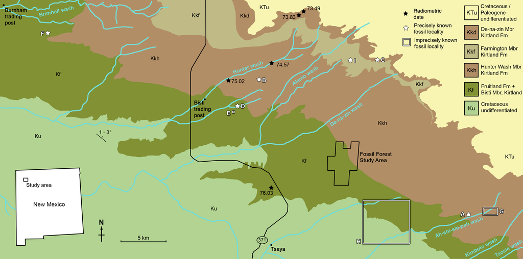
Geological map of the southeast San Juan Basin showing localities of radiometric dates and important fossil specimens mentioned in the text. Collection localities; (A) SMP VP-1500, Navajoceratops sullivani, holotype; (B) NMMNH P-27486, Terminocavus sealeyi, holotype; (C) NMMNH P-33906, Denazin chasmosaurine; (D) NMMNH P-37880, c.f. Pentaceratops sternbergii, parietal fragment; (E) UKVP 16100, c.f. P. sternbergii, complete skull; (F) MNA Pl.1747, c.f. P. sternbergii, complete skull; (G) USNM 8604, Chasmosaurinae sp. anterior end of a parietal median bar; (H) purported collection area of AMNH 6325, P. sternbergii, holotype. (I) NMMNH P-50000, Chasmosaurinae sp. (now Bisticeratops), skull missing frill. Radiometric dates recalibrated from Fassett & Steiner (1997) by Fowler (2017). Bedrock geology altered from O’Sullivan & Beikman (1963). |
| Datum | |
| Bron | https://peerj.com/articles/9251/ |
| Auteur | Denver W. Fowler, Elizabeth A. Freedman Fowler |
Licentie
Dit bestand is gelicenseerd onder de Creative Commons Naamsvermelding 4.0 Internationaal licentie.
- De gebruiker mag:
- Delen – het werk kopiëren, verspreiden en doorgeven
- Remixen – afgeleide werken maken
- Onder de volgende voorwaarden:
- naamsvermelding – U moet op een gepaste manier aan naamsvermelding doen, een link naar de licentie geven, en aangeven of er wijzigingen in het werk zijn aangebracht. U mag dit op elke redelijke manier doen, maar niet zodanig dat de indruk wordt gewekt dat de licentiegever instemt met uw werk of uw gebruik van zijn werk.
Bestandsgeschiedenis
Klik op een datum/tijd om het bestand te zien zoals het destijds was.
| Datum/tijd | Miniatuur | Afmetingen | Gebruiker | Opmerking | |
|---|---|---|---|---|---|
| huidige versie | 5 jun 2020 19:57 | | 3.250 × 1.611 (1,09 MB) | FunkMonk | {{Information |description=Geological map of the southeast San Juan Basin showing localities of radiometric dates and important fossil specimens mentioned in the text. Collection localities; (A) SMP VP-1500, Navajoceratops sullivani, holotype; (B) NMMNH P-27486, Terminocavus sealeyi, holotype; (C) NMMNH P-33906, Denazin chasmosaurine; (D) NMMNH P-37880, c.f. Pentaceratops sternbergii, parietal fragment; (E) UKVP 16100, c.f. P. sternbergii, complete skull; (F) MNA Pl.1747, c.f. P. sternbergii,... |
Bestandsgebruik
Dit bestand wordt op de volgende 2 pagina's gebruikt:
Globaal bestandsgebruik
De volgende andere wiki's gebruiken dit bestand:
- Gebruikt op en.wikipedia.org
- Gebruikt op es.wikipedia.org
- Gebruikt op fr.wikipedia.org
- Gebruikt op ja.wikipedia.org
- Gebruikt op pt.wikipedia.org
- Gebruikt op ru.wikipedia.org
- Gebruikt op zh.wikipedia.org